This table shows an overview of the protected heritage sites in the Walloon town Erquelinnes . This list is part of Belgium's national heritage.
Beschermd erfgoed is the official term to describe Flemish National Heritage Sites listed by law to protect and spread awareness of Belgian cultural heritage, specifically in Flanders. The term is also used nationwide to refer to national heritage sites. Because Belgium is officially a tri-lingual country, the other nationwide terms used in the rest of the country are the French term Bien classé and the German term Kulturdenkmal.
Erquelinnes is a Walloon municipality located in the Belgian province of Hainaut. Located on the border with France, where the commune of Maubeuge lies, Erquelinnes had a total resident population of 9,549, in 2006. The total area is 44.23 km2 (17.08 sq mi) which gives a population density of 216 inhabitants per km².
Object | Year/architect | Town/section | Address | Coordinates | Number? | Image |
---|---|---|---|---|---|---|
The towers, the main house and the stables of the castle farm Montignies-Saint-Christophe (nl)(fr) | Erquelinnes | 50°17′01″N4°11′10″E / 50.283634°N 4.186177°E | 56022-CLT-0001-01 Info | |||
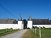
The bridge called "Pont Romain" in Montignies-Saint-Christophe (nl)(fr) | Erquelinnes | 50°16′58″N4°10′58″E / 50.282695°N 4.182742°E | 56022-CLT-0002-01 Info | |||
The Roman bridge and the surrounding land in Montignies-Saint-Christophe (nl)(fr) | Erquelinnes | 50°16′57″N4°10′52″E / 50.282441°N 4.181153°E | 56022-CLT-0003-01 Info | |||
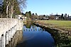
The church of Saint-Medard (nl)(fr) | Erquelinnes | 50°18′34″N4°09′05″E / 50.309423°N 4.151514°E | 56022-CLT-0004-01 Info | |||
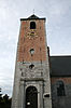
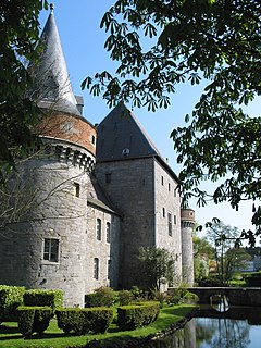
The castle of Solre-sur-Sambre (nl)(fr) | Erquelinnes | 50°18′35″N4°09′21″E / 50.309753°N 4.155708°E | 56022-CLT-0005-01 Info | |||
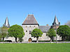
The tower of the farm "Ferme du Clocher" in Solre-sur-Sambre (nl)(fr) | Erquelinnes | 50°18′21″N4°08′49″E / 50.305739°N 4.146986°E | 56022-CLT-0006-01 Info | |||
The chapel of Saint-Antoine-sur-Sambre in Solre (nl)(fr) | Erquelinnes | 50°18′28″N4°09′14″E / 50.307691°N 4.154026°E | 56022-CLT-0007-01 Info | |||
The facades and roofs of buildings of the farm "La Tour" on the rue Notre-Dame 18 (nl)(fr) | Erquelinnes | rue Notre-Dame, 18 | 50°18′38″N4°07′29″E / 50.310446°N 4.124711°E | 56022-CLT-0008-01 Info |
Wikimedia Commons has media related to Cultural heritage monuments in Erquelinnes . |
A World Heritage Site is a landmark or area which is selected by the United Nations Educational, Scientific and Cultural Organization (UNESCO) as having cultural, historical, scientific or other form of significance, and is legally protected by international treaties. The sites are judged important to the collective interests of humanity.
Wanze is a Walloon municipality of Belgium located in the province of Liège. It consists of the former municipalities of Wanze, Antheit, Bas-Oha, Huccorgne, Moha and Vinalmont.
Bütgenbach is a municipality located in the Belgian province of Liège. On January 1, 2006, Bütgenbach had a total population of 5,574. The total area is 97.31 km² which gives a population density of 57 inhabitants per km². As part of the German-speaking Community of Belgium, the official language in this municipality is German.
Remicourt is a Walloon municipality located in the Belgian province of Liège. On January 1, 2006, Remicourt had a total population of 5,012. The total area is 22.58 km² which gives a population density of 222 inhabitants per km². It includes since 1977 the former municipalities of Momalle, Hodeige, Lamine, and Pousset.
Ferrières is a Walloon municipality located in the Belgian province of Liège. On January 1, 2006, Ferrières had a total population of 4,449. The total area is 56.90 km² with a population density of 78 inhabitants per km².
Grand-Reng is a small village located in the Belgian province of Hainaut, on the border with France. It is part of the municipality of Erquelinnes and is located on the main road from Mons to Beaumont. Its French neighbour is called Vieux-Reng.
Solre-sur-Sambre Castle is a castle in Solre-sur-Sambre in the municipality of Erquelinnes, province of Hainaut, Belgium.
The Belgian railway line 130A is a railway line in Belgium connecting Charleroi with the French border near Erquelinnes. Completed in 1852, the line runs 29.3 km. It runs along the river Sambre, crossing it several times. Beyond Erquelinnes, a French railway line continues towards Jeumont, Saint-Quentin and Paris. Until the opening of the Paris–Brussels–Cologne high-speed lines, international passenger trains between Paris and Cologne traveled along line 130A.
Charleroi-South is the main railway station serving Charleroi, Belgium. Charleroi-South is also the main TEC bus station in Charleroi, and a station of the Charleroi metro.
Heritage registers in Belgium include immovable heritage such as World Heritage Sites, and National heritage sites, but also intangible cultural heritage. The agency responsible for keeping and updating inventories of immovable heritage is dependent on the region, as is the name for the object, which is called Beschermd erfgoed, Biens classés or Kulturdenkmal depending on the language of the municipality of the location.
This page is an overview of the list of protected heritage sites in Liège (province), alphabetically ordered by town name. This list is part of the national heritage of Belgium.
This page is an overview of the list of protected heritage sites in Hainaut (province), alphabetically ordered by town name. This list is part of the protected heritage sites of Belgium.
This page is an overview of the beschermd erfgoed in Luxembourg (Belgium), alphabetically ordered by town name. This list is part of the protected heritage sites of Belgium.