This table shows an overview of the protected heritage sites in the Walloon town Gerpinnes . This list is part of Belgium's national heritage.

Beschermd erfgoed is the official term to describe Flemish National Heritage Sites listed by law to protect and spread awareness of Belgian cultural heritage, specifically in Flanders. The term is also used nationwide to refer to national heritage sites. Because Belgium is officially a tri-lingual country, the other nationwide terms used in the rest of the country are the French term Bien classé and the German term Kulturdenkmal.

Gerpinnes is a Walloon municipality located in the Belgian province of Hainaut. On 1 January 2006 the municipality had 12,030 inhabitants. The total area is 47.10 km², giving a population density of 255 inhabitants per km².
| Object | Year/architect | Town/section | Address | Coordinates | Number? | Image |
|---|---|---|---|---|---|---|
| Church of Saints-Michel-et-Rolende (nl)(fr) | Gerpinnes | 50°20′15″N4°31′35″E / 50.337588°N 4.526513°E | 52025-CLT-0001-01 Info |  | ||
| Hêtre pourpre (nl)(fr) | Gerpinnes | rue de la Brasserie, n°8 | 50°22′21″N4°28′34″E / 50.372461°N 4.476025°E | 52025-CLT-0002-01 Info | ||
| Valley of the little stream Haies (nl)(fr) | Gerpinnes | 50°22′09″N4°27′33″E / 50.369107°N 4.459240°E | 52025-CLT-0003-01 Info | |||
| Woodlands of the forest "Bois de Roumont" (nl)(fr) | Gerpinnes | 50°22′02″N4°28′53″E / 50.367180°N 4.481287°E | 52025-CLT-0004-01 Info | |||
| The tower of the fortified cemetery around the church of Saints Michel et Rolende (nl)(fr) | Gerpinnes | 50°20′15″N4°31′37″E / 50.337561°N 4.526943°E | 52025-CLT-0005-01 Info | |||
| Facades and roofs of all castle buildings at Villers-Poterie (nl)(fr) | Gerpinnes | 50°21′04″N4°32′57″E / 50.350983°N 4.549277°E | 52025-CLT-0006-01 Info | 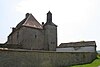 | ||
| Castle farm Villers-Poterie and its surroundings (nl)(fr) | Gerpinnes | 50°21′01″N4°32′54″E / 50.350289°N 4.548383°E | 52025-CLT-0007-01 Info | 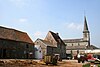 | ||
| Tomb Chapel of the family Pirmez (formerly church choir of Saint-Martin), old wall and environment (nl)(fr) | Gerpinnes | rue de l'église | 50°21′04″N4°32′49″E / 50.350994°N 4.547044°E | 52025-CLT-0009-01 Info | ||
| Calvarie chapel and environment (nl)(fr) | Gerpinnes | rue de Presles, n°1 (en face) | 50°21′01″N4°32′54″E / 50.350289°N 4.548383°E | 52025-CLT-0010-01 Info | ||
| Town hall: walls and roofs of old part and office of mayor, two towers at the entrance, gazebo, and environment (nl)(fr) | Gerpinnes | 50°20′17″N4°31′42″E / 50.338089°N 4.528382°E | 52025-CLT-0011-01 Info |  | ||
| Roman villa and surroundings (nl)(fr) | Gerpinnes | rue A. Thiebault n°11 (rechts) | 50°20′04″N4°31′24″E / 50.334360°N 4.523438°E | 52025-CLT-0013-01 Info | ||
| Forest Bois du Houdrois (nl)(fr) | Gerpinnes | 50°22′13″N4°29′20″E / 50.370236°N 4.488879°E | 52025-CLT-0014-01 Info | |||
| Woodlands of Bois de Joncret (nl)(fr) | Gerpinnes | 50°22′03″N4°28′52″E / 50.367485°N 4.481020°E | 52025-CLT-0015-01 Info | |||
| Woodlands of Bois de la Bierlîre or Bertransart (nl)(fr) | Gerpinnes | 50°21′43″N4°28′31″E / 50.361872°N 4.475181°E | 52025-CLT-0016-01 Info | |||
| Organs of the church of Saint-Martin (nl)(fr) | Gerpinnes | 50°21′18″N4°31′52″E / 50.354888°N 4.531132°E | 52025-CLT-0017-01 Info |


