List of protected heritage sites in Gesves

Last updated

This table shows an overview of the protected heritage sites in the Walloon town Gesves . This list is part of Belgium's national heritage.

Beschermd erfgoed type of heritage protection in Flanders

Beschermd erfgoed is the official term to describe Flemish National Heritage Sites listed by law to protect and spread awareness of Belgian cultural heritage, specifically in Flanders. The term is also used nationwide to refer to national heritage sites. Because Belgium is officially a tri-lingual country, the other nationwide terms used in the rest of the country are the French term Bien classé and the German term Kulturdenkmal.

Gesves Municipality in French Community, Belgium

Gesves is a Walloon municipality located in the Belgian province of Namur. This municipality contains the town of Gesves, as well as the villages of Faulx-Les-Tombes, Haltinne, Mozet, and Sorée. It also includes the hamlets of Gramptinne, Goyet, Haut-Bois, and Strud.

Object
Year/architect
Town/section
Address
Coordinates
Number?
Image
The entrance portal of the old abbey Grandpre (nl)(fr)
Gesves 50°25′07″N5°01′02″E / 50.418642°N 5.017315°E / 50.418642; 5.017315

92054-CLT-0001-01  Info

Het ingangsportaal van de oude abdij Grandpre Porche d'entree Ancienne Abbaye de Grand Pre.JPG
Het ingangsportaal van de oude abdij Grandpré
More images
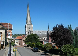
Church of Notre-Dame du Mont Carmel (nl)(fr)
Gesves 50°27′02″N5°03′26″E / 50.450445°N 5.057279°E / 50.450445; 5.057279

92054-CLT-0003-01  Info

Chapel "Mont-Sainte-Marie," old church of Notre-Dame (nl)(fr)
Gesves Mozet 50°25′46″N4°58′45″E / 50.429514°N 4.979031°E / 50.429514; 4.979031

92054-CLT-0004-01  Info

Kapel "Mont-Sainte-Marie", oude kerk Notre-Dame Mont Ste Marie 1.JPG
Kapel "Mont-Sainte-Marie", oude kerk Notre-Dame
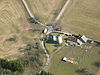
Tower of farm Marchand called "Tour du Royer" (nl)(fr)
Gesves Rue de Loyers n°4 50°26′27″N4°59′07″E / 50.440761°N 4.985400°E / 50.440761; 4.985400

92054-CLT-0007-01  Info

Toren van boerderij Marchand genaamd "Tour du Royer" 0 Mozet - Ferme-chateau Marchand (1).jpg
Toren van boerderij Marchand genaamd "Tour du Royer"
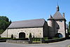
Facades and roofs of farm of the abbey of Grandpre (nl)(fr)
Gesves 50°25′06″N5°01′03″E / 50.418324°N 5.017630°E / 50.418324; 5.017630

92054-CLT-0008-01  Info

Gevels en daken van boerderij van de abdij van Grandpre Grand Pre vue aerinne.jpg
Gevels en daken van boerderij van de abdij van Grandpré
Facades and roofs of the old mill of the Abbey of Grandpre, and ensemble formed by the mill and its surroundings (nl)(fr)
Gesves 50°25′08″N5°01′04″E / 50.418927°N 5.017903°E / 50.418927; 5.017903

92054-CLT-0009-01  Info

Rochers de Roquimont (nl)(fr)
Gesves 50°25′42″N4°59′10″E / 50.428389°N 4.986197°E / 50.428389; 4.986197

92054-CLT-0010-01  Info

Ensemble of the rocks "Les Demoiselles" in the hamlet of Forges in the valley of the Samson (nl)(fr)
Gesves 50°27′08″N5°00′48″E / 50.452171°N 5.013349°E / 50.452171; 5.013349

92054-CLT-0011-01  Info

Rochers de Goyet (nl)(fr)
Gesves 50°26′41″N5°00′05″E / 50.444847°N 5.001439°E / 50.444847; 5.001439

92054-CLT-0012-01  Info

Ensemble of the church of Notre-Dame du Mont Carmel and the surrounding area (nl)(fr)
Gesves 50°27′02″N5°03′24″E / 50.450498°N 5.056713°E / 50.450498; 5.056713

92054-CLT-0013-01  Info

Castle Haltinne and the ensemble formed by the building and surrounding grounds (nl)(fr)
Gesves 50°27′05″N5°04′43″E / 50.451282°N 5.078519°E / 50.451282; 5.078519

92054-CLT-0014-01  Info

Kasteel van Haltinne en het ensemble gevormd door het gebouw en het omliggende terrein 0 Haltinne - Chateau (1).jpg
Kasteel van Haltinne en het ensemble gevormd door het gebouw en het omliggende terrein
More images
A portion of the channel of Samson in the buildings of the abbey of Grandpre (nl)(fr)
Gesves 50°25′08″N5°01′03″E / 50.418767°N 5.017469°E / 50.418767; 5.017469

92054-CLT-0015-01  Info

Part of the village Mozet (nl)(fr)
Gesves 50°26′35″N4°59′18″E / 50.443109°N 4.988433°E / 50.443109; 4.988433

92054-CLT-0016-01  Info

Een deel van het dorp Mozet 0 Mozet - Ferme de Basseille (1).jpg
Een deel van het dorp Mozet
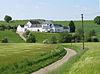
Facades, roofs and canals with the grand staircase of the castle of Haltinne (nl)(fr)
Gesves 50°27′05″N5°04′43″E / 50.451282°N 5.078519°E / 50.451282; 5.078519

92054-PEX-0001-01  Info

See also

Related Research Articles

World Heritage Site place listed by the UNESCO as of special cultural or natural significance

A World Heritage Site is a landmark or area which is selected by the United Nations Educational, Scientific and Cultural Organization (UNESCO) as having cultural, historical, scientific or other form of significance, and is legally protected by international treaties. The sites are judged important to the collective interests of humanity.

Wanze Municipality in French Community, Belgium

Wanze is a Walloon municipality of Belgium located in the province of Liège. It consists of the former municipalities of Wanze, Antheit, Bas-Oha, Huccorgne, Moha and Vinalmont.

Baelen Municipality in French Community, Belgium

Baelen is a Belgian municipality located in the Walloon province of Liège. On January 1, 2006, Baelen had a total population of 4,060. The total area is 85.73 km² which gives a population density of 47.36 inhabitants per km².

Bütgenbach Municipality in German-speaking Community, Belgium

Bütgenbach is a municipality located in the Belgian province of Liège. On January 1, 2006, Bütgenbach had a total population of 5,574. The total area is 97.31 km² which gives a population density of 57 inhabitants per km². As part of the German-speaking Community of Belgium, the official language in this municipality is German.

Raeren Municipality in German-speaking Community, Belgium

Raeren is a municipality located in the Belgian province of Liège. It was part of Germany until the First World War, after which it became part of Belgium. It is one of several towns in Eastern Belgium which still predominantly speak German.

Remicourt, Belgium Municipality in French Community, Belgium

Remicourt is a Walloon municipality located in the Belgian province of Liège. On January 1, 2006, Remicourt had a total population of 5,012. The total area is 22.58 km² which gives a population density of 222 inhabitants per km². It includes since 1977 the former municipalities of Momalle, Hodeige, Lamine, and Pousset.

Ferrières, Belgium Municipality in French Community, Belgium

Ferrières is a Walloon municipality located in the Belgian province of Liège. On January 1, 2006, Ferrières had a total population of 4,449. The total area is 56.90 km² with a population density of 78 inhabitants per km².

Faulx-les-Tombes Castle section of Gesves, Belgium

Faulx-les-Tombes Castle is a 19th-century château in Faulx-les-Tombes in the municipality of Gesves, province of Namur, Belgium.

Heritage registers in Belgium cultural property of Belgium

Heritage registers in Belgium include immovable heritage such as World Heritage Sites, and National heritage sites, but also intangible cultural heritage. The agency responsible for keeping and updating inventories of immovable heritage is dependent on the region, as is the name for the object, which is called Beschermd erfgoed, Biens classés or Kulturdenkmal depending on the language of the municipality of the location.

This page is an overview of the list of protected heritage sites in Liège (province), alphabetically ordered by town name. This list is part of the national heritage of Belgium.

This page is an overview of the list of protected heritage sites in Hainaut (province), alphabetically ordered by town name. This list is part of the protected heritage sites of Belgium.

This page is an overview of the beschermd erfgoed in Luxembourg (Belgium), alphabetically ordered by town name. This list is part of the protected heritage sites of Belgium.

References