This table shows an overview of the protected heritage sites in the Flemish town Gingelom . This list is part of Belgium's national heritage.

Beschermd erfgoed is the official term to describe Flemish National Heritage Sites listed by law to protect and spread awareness of Belgian cultural heritage, specifically in Flanders. The term is also used nationwide to refer to national heritage sites. Because Belgium is officially a tri-lingual country, the other nationwide terms used in the rest of the country are the French term Bien classé and the German term Kulturdenkmal.

Gingelom is a municipality located in the Belgian province of Limburg. On 1 January 2006 Gingelom had a total population of 7,847. The total area is 56.49 km² which gives a population density of 139 inhabitants per km².
| Object | Status? | Year/architect | Town/section | Address | Coordinates | Number? | Image |
|---|---|---|---|---|---|---|---|
| Kamerijckhoeve closed farm (nl) | Gingelom | Kamerijckstraat 11 | 50°45′35″N5°08′00″E / 50.75960°N 5.13339°E | 21628 Info |  | ||
| Closed farm (nl)(fr) | Gingelom | Katseistraat 18 | 50°44′54″N5°07′47″E / 50.74820°N 5.12959°E | 21629 Info | |||
| Closed farm (nl)(fr) | Gingelom | Kriekelstraat 1 | 50°45′05″N5°08′13″E / 50.75149°N 5.13688°E | 21630 Info | |||
| Chapel of Our Lady Immaculate-Received (nl)(fr) | Gingelom | Landenstraat | 50°44′53″N5°07′13″E / 50.74803°N 5.12040°E | 21631 Info | |||
| Closed farm (nl)(fr) | Gingelom | Mgr. Keesenstraat 12 | 50°45′06″N5°08′10″E / 50.75155°N 5.13608°E | 21632 Info | |||
| Square Farm (nl)(fr) | Gingelom | Opheimstraat 2 | 50°45′09″N5°08′04″E / 50.75246°N 5.13443°E | 21634 Info | |||
| Castle of Baron Louis Erasmus Surlet the Chokier (nl)(fr) | Gingelom | Regentwijk 80 | 50°45′03″N5°07′47″E / 50.75081°N 5.12972°E | 21635 Info | |||
| St. Peter Parish Church (nl)(fr) | Gingelom | Sint-Pieterstraat 2 | 50°45′01″N5°08′07″E / 50.75038°N 5.13534°E | 21636 Info |  | ||
| section house, double house neoclassical (nl)(fr) | Gingelom | Sint-Pieterstraat 1 | 50°45′00″N5°08′06″E / 50.74991°N 5.13488°E | 21637 Info | |||
| Rectory (nl)(fr) | Gingelom | Steenstraat 2 | 50°45′03″N5°08′07″E / 50.75087°N 5.13535°E | 21640 Info | |||
| Closed farm (nl)(fr) | Gingelom | Steenstraat 20 | 50°45′08″N5°07′55″E / 50.75232°N 5.13208°E | 21641 Info | |||
| St. John's Farm, closed farm (nl)(fr) | Gingelom | Steenstraat 29 | 50°45′06″N5°07′54″E / 50.75160°N 5.13166°E | 21642 Info | |||
| Closed farm (nl)(fr) | Gingelom | Fonteinstraat 16 | 50°44′21″N5°08′25″E / 50.73911°N 5.14037°E | 21643 Info | |||
| Parish Church St. Sebastian (nl)(fr) | Gingelom | Naamsestraat 33 | 50°44′29″N5°08′22″E / 50.74148°N 5.13958°E | 21644 Info |  | ||
| Closed farm (nl)(fr) | Gingelom | Naamsestraat 43 | 50°44′30″N5°08′28″E / 50.74176°N 5.14105°E | 21645 Info | |||
| Chapel of Our Lady of Assistance- (nl)(fr) | Gingelom | Oude Katsei | 50°44′23″N5°08′45″E / 50.73986°N 5.14597°E | 21647 Info | |||
| Semi-closed farm (nl)(fr) | Gingelom | Oude Katsei 76 | 50°44′32″N5°08′27″E / 50.74233°N 5.14074°E | 21648 Info | |||
| U-shaped farm complex (nl)(fr) | Gingelom | Oude Katsei 77 | 50°44′32″N5°08′34″E / 50.74233°N 5.14279°E | 21649 Info | |||
| U-shaped farm complex (nl)(fr) | Gingelom | Oude Katsei 79 | 50°44′32″N5°08′34″E / 50.74233°N 5.14279°E | 21649 Info | |||
| Farmhouse of 1811 (nl)(fr) | Gingelom | Oude Katsei 89 | 50°44′28″N5°08′37″E / 50.74107°N 5.14363°E | 21650 Info | |||
| Chapel of Our Lady of Lourdes from 1877 (nl)(fr) | Gingelom | Statiestraat | 50°44′25″N5°08′07″E / 50.74031°N 5.13529°E | 21651 Info | |||
| Farm and former distillery (nl)(fr) | Gingelom | Bergstraat 11 | 50°44′23″N5°10′40″E / 50.73968°N 5.17777°E | 21652 Info | |||
| Farmhouse of 1814 (nl)(fr) | Gingelom | Bergstraat 4 | 50°44′30″N5°10′48″E / 50.74162°N 5.18008°E | 21653 Info | |||
| Closed farm (nl)(fr) | Gingelom | Bergstraat 8 | 50°44′27″N5°10′46″E / 50.74074°N 5.17949°E | 21654 Info | |||
| Closed farm (nl)(fr) | Gingelom | Bergstraat 10 | 50°44′26″N5°10′42″E / 50.74063°N 5.17823°E | 21655 Info | |||
| "Hof Massa" farm (nl) | Gingelom | Dorpsplein 1 | 50°44′33″N5°10′52″E / 50.74244°N 5.18122°E | 21656 Info | |||
| Closed farm (nl)(fr) | Gingelom | Dorpsplein 3 | 50°44′32″N5°10′56″E / 50.74211°N 5.18212°E | 21657 Info | |||
| Semi-closed farm (nl)(fr) | Gingelom | Dorpsplein 5 | 50°44′32″N5°10′57″E / 50.74229°N 5.18242°E | 21658 Info | |||
| Watermill (former) (nl)(fr) | Gingelom | Molenstraat 3 | 50°44′31″N5°11′01″E / 50.74203°N 5.18371°E | 21659 Info | |||
| Semi-closed farm (nl)(fr) | Gingelom | Nieuwstraat 13 | 50°44′35″N5°11′03″E / 50.74293°N 5.18425°E | 21660 Info | |||
| St. Peter Parish Church (nl)(fr) | Gingelom | Thewitstraat | 50°44′30″N5°10′52″E / 50.74180°N 5.18109°E | 21661 Info |  | ||
| Chapel of Our Lady of Sorrows-of 1892 (nl)(fr) | Gingelom | Thewitstraat | 50°44′21″N5°10′49″E / 50.73929°N 5.18037°E | 21662 Info | |||
| Presbytery, double house (nl)(fr) | Gingelom | Thewitstraat 2 | 50°44′30″N5°10′53″E / 50.74155°N 5.18135°E | 21663 Info | |||
| Square Farm (nl)(fr) | Gingelom | Thewitstraat 10 | 50°44′27″N5°10′58″E / 50.74090°N 5.18271°E | 21665 Info | |||
| Closed farm (nl)(fr) | Gingelom | Thewitstraat 17 | 50°44′23″N5°10′53″E / 50.73978°N 5.18139°E | 21666 Info | |||
| Chapel of Our Lady of Assistance- (nl)(fr) | Gingelom | Gravelostraat | 50°45′06″N5°10′53″E / 50.75159°N 5.18142°E | 21667 Info | |||
| Parish St. Trudo (nl)(fr) | Gingelom | Sint-Trudostraat 3/2 | 50°45′09″N5°10′35″E / 50.75244°N 5.17628°E | 21668 Info | 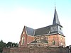 | ||
| Presbytery neoclassical double house (nl)(fr) | Gingelom | Sint-Trudostraat 1 | 50°45′07″N5°10′33″E / 50.75200°N 5.17595°E | 21669 Info | |||
| Home of a former farm complex (nl)(fr) | Gingelom | Truilingenstraat 48 | 50°45′12″N5°10′33″E / 50.75344°N 5.17597°E | 21670 Info | |||
| Farm Terwing (nl) | Gingelom | Truilingenstraat 85 | 50°44′55″N5°10′34″E / 50.74864°N 5.17619°E | 21671 Info | |||
| St. Anne Chapel (nl)(fr) | Gingelom | Daalstraat | 50°45′45″N5°12′54″E / 50.76250°N 5.21509°E | 21672 Info | |||
| Farm "Joris" (nl) | Gingelom | Daalstraat 12 | 50°45′43″N5°12′47″E / 50.76187°N 5.21310°E | 21673 Info | |||
| Parish St. Saturninus (nl)(fr) | Gingelom | Kerkstraat 1 | 50°45′20″N5°12′57″E / 50.75544°N 5.21574°E | 21674 Info |  | ||
| Rectory (nl)(fr) | Gingelom | Kerkstraat 2 | 50°45′20″N5°12′56″E / 50.75569°N 5.21545°E | 21675 Info | |||
| "De Daalhoeve" (nl) | Gingelom | Truierstraat | 50°45′38″N5°12′44″E / 50.76054°N 5.21222°E | 21676 Info | |||
| Help Holy Cross Chapel (nl)(fr) | Gingelom | Kruisstraat 8 | 50°45′34″N5°10′38″E / 50.75934°N 5.17735°E | 21678 Info |  | ||
| Kloosterhoeve (former) (nl)(fr) | Gingelom | Truilingenstraat 17 | 50°45′39″N5°10′32″E / 50.76078°N 5.17556°E | 21680 Info | |||
| Hassel Castle Pants (nl)(fr) | Gingelom | Hasselbroekstraat 188 | 50°43′19″N5°12′35″E / 50.72203°N 5.20979°E | 21682 Info | 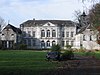 | ||
| St. Jobkapel (nl)(fr) | Gingelom | Hasselbroekstraat | 50°43′14″N5°12′39″E / 50.72063°N 5.21081°E | 21683 Info | 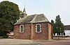 | ||
| Agriculture Gillams Distillery, closed farm (nl)(fr) | Gingelom | Hasselbroekstraat 186 | 50°43′25″N5°12′36″E / 50.72360°N 5.20994°E | 21684 Info | |||
| Neoclassical house (nl)(fr) | Gingelom | Hasselbroekstraat 181 | 50°43′29″N5°12′40″E / 50.72467°N 5.21115°E | 21685 Info | |||
| U-shaped farm (nl)(fr) | Gingelom | Hasselbroekstraat 213 | 50°43′17″N5°12′41″E / 50.72145°N 5.21147°E | 21686 Info | |||
| Farm Stassens or "De Witte Hoeve" (nl) | Gingelom | Hasselbroekstraat | 50°43′14″N5°12′41″E / 50.72064°N 5.21142°E | 21687 Info |  | ||
| St. Amands Chapel (nl)(fr) | Gingelom | Heiseltstraat | 50°43′56″N5°13′43″E / 50.73216°N 5.22853°E | 21688 Info | |||
| Parish Church of Saint George (nl)(fr) | Gingelom | Houtstraat 60 | 50°44′03″N5°12′33″E / 50.73418°N 5.20924°E | 21689 Info |  | ||
| Snyers distillery, farm and agricultural distillery (nl)(fr) | Gingelom | Houtstraat 98 | 50°43′54″N5°12′31″E / 50.73164°N 5.20850°E | 21690 Info | |||
| "Lindehoeve" or "Ferme du Tilleul" (nl) | Gingelom | Houtstraat 65 | 50°44′04″N5°12′37″E / 50.73447°N 5.21026°E | 21691 Info | |||
| Distillery Snyers-Goyens, farm and distillery (nl)(fr) | Gingelom | Hundelingenstraat 42 | 50°44′23″N5°12′28″E / 50.73962°N 5.20781°E | 21693 Info | |||
| Chapel of Our Lady of Little Itch (nl)(fr) | Gingelom | Klein-Jeukstraat 26 | 50°43′55″N5°11′29″E / 50.73198°N 5.19131°E | 21694 Info |  | ||
| Mechanical mill (former) (nl)(fr) | Gingelom | Spoorwegstraat 36 | 50°43′16″N5°11′18″E / 50.72113°N 5.18820°E | 21695 Info | |||
| St. Peter's Parish Church (nl) | Gingelom | Boekhoutstraat | 50°44′47″N5°14′01″E / 50.74643°N 5.23351°E | 21696 Info |  | ||
| Classical house (nl)(fr) | Gingelom | Boekhoutstraat 7 | 50°45′00″N5°14′06″E / 50.74998°N 5.23502°E | 21697 Info | |||
| Farm (former) (nl)(fr) | Gingelom | Bosschellestraat 11 | 50°43′01″N5°07′49″E / 50.71683°N 5.13018°E | 21698 Info | |||
| St. Martin Parish (nl) | Gingelom | Brugstraat | 50°43′17″N5°07′43″E / 50.72129°N 5.12864°E | 21699 Info |  | ||
| Farmhouse with separate components (nl)(fr) | Gingelom | Brugstraat 4 | 50°43′17″N5°07′41″E / 50.72134°N 5.12800°E | 21700 Info | |||
| Presbytery, broad style house neotradionele (nl)(fr) | Gingelom | Brugstraat 8 | 50°43′16″N5°07′44″E / 50.72114°N 5.12900°E | 21701 Info | |||
| Closed farm (nl)(fr) | Gingelom | Brugstraat 11 | 50°43′14″N5°07′44″E / 50.72042°N 5.12900°E | 21702 Info | |||
| Farmer house (nl) | Gingelom | Brugstraat 14 | 50°43′14″N5°07′46″E / 50.72047°N 5.12957°E | 21703 Info | |||
| Closed farm (nl)(fr) | Gingelom | Brugstraat 17 | 50°43′16″N5°07′49″E / 50.72099°N 5.13039°E | 21704 Info | |||
| Brewery of 1858 (former) (nl)(fr) | Gingelom | Brugstraat 33 | 50°43′22″N5°07′50″E / 50.72265°N 5.13048°E | 21705 Info | |||
| Farmhouse with separate components (nl)(fr) | Gingelom | Dr. Kempeneersstraat 131 | 50°43′11″N5°08′41″E / 50.71973°N 5.14466°E | 21706 Info | |||
| Our Lady Chapel of 1839 (nl)(fr) | Gingelom | sectionstraat | 50°43′48″N5°08′26″E / 50.72987°N 5.14052°E | 21707 Info | |||
| Farm Nerem, water mill on the farm with Jean (nl)(fr) | Gingelom | sectionstraat 11 | 50°43′50″N5°08′30″E / 50.73055°N 5.14179°E | 21708 Info | |||
| Farmer house of 1865 (nl) | Gingelom | Gezusters Dehasquestraat 5 | 50°43′26″N5°07′51″E / 50.72392°N 5.13073°E | 21709 Info | |||
| St. Rumoldus Chapel (nl)(fr) | Gingelom | Groenplaats | 50°43′03″N5°08′44″E / 50.71751°N 5.14564°E | 21710 Info |  | ||
| Classicist mansion (nl)(fr) | Gingelom | Groenplaats 5 | 50°43′06″N5°08′51″E / 50.71832°N 5.14738°E | 21711 Info | |||
| Closed farm (nl)(fr) | Gingelom | Groenplaats 6 | 50°43′03″N5°08′48″E / 50.71753°N 5.14661°E | 21712 Info | |||
| Closed farm (nl)(fr) | Gingelom | Groenplaats 7 | 50°43′03″N5°08′48″E / 50.71753°N 5.14661°E | 21712 Info | |||
| Farm with standalone components (nl)(fr) | Gingelom | Groenplaats 21 | 50°43′05″N5°08′41″E / 50.71797°N 5.14477°E | 21713 Info | |||
| Village house (nl)(fr) | Gingelom | Haagstraat 8 | 50°43′12″N5°08′48″E / 50.71997°N 5.14672°E | 21714 Info | |||
| Square Farm (nl)(fr) | Gingelom | Haagstraat 9 | 50°43′12″N5°08′50″E / 50.71995°N 5.14736°E | 21715 Info | |||
| "Bonaertshoeve" hoeve (nl) | Gingelom | Haagstraat 14 | 50°43′21″N5°08′47″E / 50.72261°N 5.14652°E | 21716 Info | |||
| "Blauwe Hoeve" (nl) | Gingelom | Hannuitstraat 9 | 50°43′10″N5°07′37″E / 50.71938°N 5.12684°E | 21718 Info | |||
| Closed farm (nl)(fr) | Gingelom | Hannuitstraat 18 | 50°43′04″N5°07′36″E / 50.71764°N 5.12679°E | 21719 Info | |||
| Closed farm (nl)(fr) | Gingelom | Hannuitstraat 19 | 50°43′04″N5°07′36″E / 50.71764°N 5.12679°E | 21719 Info | |||
| Closed farm (nl)(fr) | Gingelom | Langstraat 18 | 50°43′18″N5°08′02″E / 50.72161°N 5.13394°E | 21722 Info | |||
| Closed farm (nl)(fr) | Gingelom | Langstraat 20 | 50°43′18″N5°08′02″E / 50.72161°N 5.13394°E | 21722 Info | |||
| Farmer house of 1862 (nl) | Gingelom | Langstraat 68 | 50°43′16″N5°08′18″E / 50.72124°N 5.13826°E | 21723 Info | |||
| Manor house and farm buildings (nl)(fr) | Gingelom | Marktplaats 1 | 50°43′17″N5°07′38″E / 50.72137°N 5.12718°E | 21724 Info | |||
| Manor house and farm buildings (nl)(fr) | Gingelom | Marktplaats 2 | 50°43′17″N5°07′38″E / 50.72137°N 5.12718°E | 21724 Info | |||
| Mansion (nl)(fr) | Gingelom | Hannuitstraat 4 | 50°43′12″N5°07′36″E / 50.72000°N 5.12678°E | 21725 Info | |||
| Closed farm (nl)(fr) | Gingelom | Marktplaats 11 | 50°43′15″N5°07′35″E / 50.72089°N 5.12640°E | 21726 Info | |||
| "Linthouthoeve", semi-closed farm (nl) | Gingelom | Montenakenstraat 11 | 50°43′47″N5°07′33″E / 50.72985°N 5.12588°E | 21728 Info | |||
| section house, broad eclectic house (former) (nl) | Gingelom | Peremplaats 1 | 50°43′19″N5°07′54″E / 50.72187°N 5.13161°E | 21729 Info | |||
| Closed farm, now two houses (nl) | Gingelom | Riddersstraat 24 | 50°43′23″N5°08′08″E / 50.72315°N 5.13569°E | 21730 Info | |||
| Closed farm (nl) | Gingelom | Sint-Rumoldusstraat 8 | 50°43′12″N5°07′58″E / 50.71997°N 5.13284°E | 21731 Info | |||
| Our Lady of Step Chapel (nl) | Gingelom | Stepsstraat 1 | 50°43′14″N5°07′30″E / 50.72047°N 5.12498°E | 21732 Info |  | ||
| Mary Magdalene Parish Church (nl) | Gingelom | Pastorijstraat | 50°42′26″N5°09′03″E / 50.70728°N 5.15078°E | 21733 Info |  | ||
| Square Farm (nl) | Gingelom | Kapelstraat 8 | 50°42′32″N5°08′56″E / 50.70877°N 5.14882°E | 21734 Info | |||
| Our Lady Chapel (nl) | Gingelom | Duivenstraat | 50°42′44″N5°08′12″E / 50.71216°N 5.13663°E | 21736 Info | |||
| Paenhuys or banbrouwerij (former) (nl)(fr) | Gingelom | Brouwerijstraat 2 | 50°42′12″N5°10′16″E / 50.70331°N 5.17115°E | 21737 Info | |||
| double House (nl) | Gingelom | Hoogstraat 14 | 50°42′11″N5°10′04″E / 50.70318°N 5.16771°E | 21738 Info | |||
| section house of 1893 (former) (nl)(fr) | Gingelom | Hoogstraat 17 | 50°42′17″N5°10′11″E / 50.70462°N 5.16985°E | 21739 Info | |||
| Presbytery of 1845 (nl)(fr) | Gingelom | Hoogstraat 32 | 50°42′16″N5°10′18″E / 50.70453°N 5.17173°E | 21740 Info | |||
| Residence (nl)(fr) | Gingelom | Hoogstraat 33 | 50°42′19″N5°10′24″E / 50.70520°N 5.17330°E | 21741 Info | |||
| Farmstead "Jadoul" (nl)(fr) | Gingelom | Hoogstraat 34 | 50°42′15″N5°10′24″E / 50.70419°N 5.17343°E | 21742 Info | |||
| Parish Holy Cross (nl)(fr) | Gingelom | Brouwerijstraat | 50°42′15″N5°10′19″E / 50.70404°N 5.17192°E | 21743 Info |  | ||
| Source of Our Lady Chapel (nl)(fr) | Gingelom | Bronstraat | 50°45′09″N5°12′54″E / 50.75252°N 5.21496°E | 83593 Info | |||
| (former) police headquarters (nl)(fr) | Gingelom | Brugstraat 16 | 50°43′16″N5°07′46″E / 50.72106°N 5.12939°E | 83594 Info | |||
| "Bronhoeve" (nl) | Gingelom | Bronstraat 9 | 50°45′13″N5°12′46″E / 50.75371°N 5.21285°E | 83601 Info | |||
| "Stepshoeve" or "Berwaerhoeve" (nl) | Gingelom | Stepsstraat 9 | 50°43′13″N5°07′28″E / 50.72017°N 5.12454°E | 83767 Info | |||
| The "Drie Tommen" (nl) | Gingelom | Drie Tombenstraat | 50°42′35″N5°09′40″E / 50.70973°N 5.16121°E | 200323 Info |  |

