This table shows an overview of the protected heritage sites in the Walloon town Gouvy . This list is part of Belgium's national heritage.

Beschermd erfgoed is the official term to describe Flemish National Heritage Sites listed by law to protect and spread awareness of Belgian cultural heritage, specifically in Flanders. The term is also used nationwide to refer to national heritage sites. Because Belgium is officially a tri-lingual country, the other nationwide terms used in the rest of the country are the French term Bien classé and the German term Kulturdenkmal.

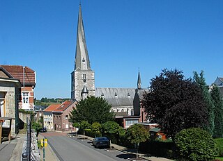
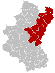
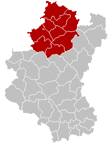
Gouvy is a Walloon municipality of Belgium located in the province of Luxembourg.
| Object | Year/architect | Town/section | Address | Coordinates | Number? | Image |
|---|---|---|---|---|---|---|
| Church of Saint-Pierre (nl)(fr) | Gouvy | Beho | 50°13′14″N5°59′50″E / 50.220648°N 5.997244°E | 82037-CLT-0001-01 Info |  | |
| Chapel Saint Hubert et Antoine and the ensemble of thechapel, the cemetery and the rocky promontory on the road and the river to the south and west (nl)(fr) | Gouvy | Wathermael-Beho | 50°10′46″N5°58′48″E / 50.179380°N 5.980129°E | 82037-CLT-0002-01 Info | 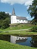 | |
| Ensemble of the chapel of Saint-Martin and the surrounding areas (nl)(fr) | Gouvy | Bovigny | 50°13′16″N5°56′44″E / 50.221171°N 5.945466°E | 82037-CLT-0003-01 Info | ||
| Church of St. Vincent (nl)(fr) | Gouvy | Cherain | 50°10′51″N5°51′55″E / 50.180950°N 5.865350°E | 82037-CLT-0004-01 Info |  | |
| The walls of the cemetery of the Church of St. Vincent in Cherain, whose church is classified by Royal Decree of 26 September 1947, and the buildings on the square, place de Cherain and the ensemble of buildings and surrounding areas, including the Cemetery Cherain (nl)(fr) | Gouvy | 50°10′52″N5°51′55″E / 50.181110°N 5.865315°E | 82037-CLT-0006-01 Info | |||
| Building (nl)(fr) | Gouvy | rue de l'Eglise n°3, Gouvy | 50°11′06″N5°56′33″E / 50.184976°N 5.942619°E | 82037-CLT-0007-01 Info | ||
| Organs of the church of the Saints Pierre et Paul (nl)(fr) | Gouvy | Steinbach | 50°08′41″N5°54′06″E / 50.144713°N 5.901734°E | 82037-CLT-0008-01 Info | ||
| Castle of Steinbach (nl)(fr) | Gouvy | Gouvy | 50°08′43″N5°54′10″E / 50.145173°N 5.902712°E | 82037-CLT-0010-01 Info | ||
| La Croix located on the road to Salm (nl)(fr) | Gouvy | Gouvy | 50°11′13″N5°56′22″E / 50.186853°N 5.939538°E | 82037-CLT-0011-01 Info | ||
| Chapel Notre-Dame de Lourdes, and the ensemble of the chapel and its surroundings (nl)(fr) | Gouvy | Baclain | 50°11′31″N5°51′50″E / 50.191919°N 5.863910°E | 82037-CLT-0013-01 Info | ||
| Mill (facades, roofs and rooms with machinery), basketry Beaupain (facades and roofs), the old bridge of the mill, the range of the mill, including the valves, the waterfall, the wheel, the sealing tunnel Cierreux and the ensemble of this building and its environment (nl)(fr) | Gouvy | 50°14′34″N5°55′20″E / 50.242705°N 5.922120°E | 82037-CLT-0014-01 Info | |||
| The rectory of the parish of Saint-Martin (nl)(fr) | Gouvy | Gouvy | 50°13′29″N5°55′04″E / 50.224690°N 5.917744°E | 82037-CLT-0017-01 Info | ||
| The walls of the cemetery and the road, and the ensemble of the cemetery and the road to the church (nl)(fr) | Gouvy | Gouvy | 50°13′14″N5°59′49″E / 50.220542°N 5.996986°E | 82037-CLT-0018-01 Info | ||
| Tower of the church of Saint-Martin, the surrounding wall around the cemetery and the ensemble of the building and its surroundings (nl)(fr) | Gouvy | Bovigny | 50°13′29″N5°55′05″E / 50.224794°N 5.918179°E | 82037-CLT-0019-01 Info | ||
| Facades and roofs of the castle of Sterpigny, and the ensemble of the castle and its surroundings (nl)(fr) | Gouvy | 50°11′05″N5°53′02″E / 50.184604°N 5.883964°E | 82037-CLT-0021-01 Info | |||
| The southern part of the barn to Sterpigny of the castle, whose walls and roofs, and the old crucifix on the road were classified in the Executive Order of 16 June 1988 and the plot is an extension of the classified site with the executive decision of 16 June 1988 (nl)(fr) | Gouvy | 50°11′04″N5°53′03″E / 50.184335°N 5.884113°E | 82037-CLT-0022-01 Info | |||
| Castle farm of mesnil: facades, roofs and entrance portal and the ensemble of these buildings and the surrounding areas (nl)(fr) | Gouvy | rue du Centre | 50°08′48″N5°54′14″E / 50.146716°N 5.904010°E | 82037-CLT-0025-01 Info | ||
| The facades, roof and the porch of the house Caprasse and doors, interior woodwork and staircase, the cobbled courtyard, the walls and roofs of the outbuildings and adjoining farm, with the surrounding walls, the pond and the formation of the eastern boundary of cadastral plot 1070 and the ensemble of these buildings and the surrounding areas (nl)(fr) | Gouvy | 50°10′42″N5°51′29″E / 50.178452°N 5.858133°E | 82037-CLT-0026-01 Info | |||
| Totality of the chapel of Saint-Roch (nl)(fr) | Gouvy | Renglez | 50°10′03″N5°53′05″E / 50.167570°N 5.884702°E | 82037-CLT-0028-01 Info | ||
| North Wing Castle Steinbach (nl)(fr) | Gouvy | Limerlé | 50°08′43″N5°54′10″E / 50.145338°N 5.902809°E | 82037-CLT-0030-01 Info | ||
| The uniqueness of the buffet and the organ of the church of Saints Pierre et Paul (nl)(fr) | Gouvy | 50°08′41″N5°54′06″E / 50.144713°N 5.901734°E | 82037-PEX-0001-01 Info |