This table shows an overview of the protected heritage sites in the Flemish town Halen . This list is part of Belgium's national heritage.

Beschermd erfgoed is the official term to describe Flemish National Heritage Sites listed by law to protect and spread awareness of Belgian cultural heritage, specifically in Flanders. The term is also used nationwide to refer to national heritage sites. Because Belgium is officially a tri-lingual country, the other nationwide terms used in the rest of the country are the French term Bien classé and the German term Kulturdenkmal.

Halen, formerly Haelen, is a municipality located in the Belgian province of Limburg, to the west of Hasselt. On January 1, 2012, Halen had a total population of 9,352. The total area is 36.29 km² which gives a population density of 258 inhabitants per km².
| Object | Status? | Year/architect | Town/section | Address | Coordinates | Number? | Image |
|---|---|---|---|---|---|---|---|
| "Hoeve Vogel-sanck" farm (nl) | Halen | Betserbaan 72 | 50°57′15″N5°05′34″E / 50.95409°N 5.09268°E | 21744 Info | |||
| farm (nl) | Halen | Betserbaan 76 | 50°57′11″N5°05′37″E / 50.95296°N 5.09369°E | 21745 Info | |||
| farm (nl) | Halen | Ertsenrijkstraat 107 | 50°55′45″N5°07′28″E / 50.92907°N 5.12451°E | 21748 Info | |||
| Closed farm 1852 (nl) | Halen | Ertsenrijkstraat 115 | 50°55′32″N5°07′27″E / 50.92547°N 5.12416°E | 21749 Info | |||
| lock (nl) | Halen | Firmin Jacobslaan | 50°56′53″N5°07′01″E / 50.94803°N 5.11688°E | 21750 Info | |||
| broad House (nl) | Halen | Generaal de Wittestraat 3 | 50°56′54″N5°06′48″E / 50.94830°N 5.11328°E | 21752 Info | |||
| double House (nl) | Halen | Generaal de Wittestraat 5 | 50°56′54″N5°06′47″E / 50.94838°N 5.11302°E | 21753 Info | |||
| double House (nl) | Halen | Generaal de Wittestraat 10 | 50°56′53″N5°06′45″E / 50.94799°N 5.11262°E | 21755 Info | |||
| double House (nl) | Halen | Generaal de Wittestraat 12 | 50°56′53″N5°06′45″E / 50.94799°N 5.11262°E | 21755 Info | |||
| double House (nl) | Halen | Generaal de Wittestraat 14 | 50°56′53″N5°06′45″E / 50.94799°N 5.11239°E | 21756 Info | |||
| double House (nl) | Halen | Generaal de Wittestraat 21 | 50°56′54″N5°06′44″E / 50.94831°N 5.11210°E | 21757 Info | |||
| double House (nl) | Halen | Koepoortstraat 5 | 50°56′56″N5°06′53″E / 50.94893°N 5.11479°E | 21760 Info | |||
| Iron Mining farm (nl) | Halen | Ijzerwinningstraat 2 | 50°56′32″N5°05′18″E / 50.94228°N 5.08834°E | 21761 Info | |||
| Parish St. Peter-in-Banden (nl) | Halen | Markt | 50°56′55″N5°06′53″E / 50.94862°N 5.11466°E | 21764 Info |  | ||
| double House (nl) | Halen | Markt 9 | 50°56′53″N5°06′49″E / 50.94796°N 5.11357°E | 21765 Info | |||
| only House (nl) | Halen | Markt 11 | 50°56′51″N5°06′49″E / 50.94757°N 5.11367°E | 21766 Info | |||
| two homes (nl) | Halen | Marktstraat 4 | 50°56′50″N5°06′55″E / 50.94718°N 5.11520°E | 21771 Info | |||
| Farmer Burger House 1824 (nl) | Halen | Nederstraat 1 | 50°56′53″N5°06′55″E / 50.94812°N 5.11516°E | 21772 Info | |||
| two homes (nl) | Halen | Staatsbaan 106 | 50°57′35″N5°05′11″E / 50.95977°N 5.08641°E | 21774 Info | |||
| two homes (nl) | Halen | Staatsbaan 108 | 50°57′35″N5°05′11″E / 50.95977°N 5.08641°E | 21774 Info | |||
| broad House (nl) | Halen | Zepbrugstraat 34 | 50°56′25″N5°06′20″E / 50.94039°N 5.10543°E | 21778 Info | |||
| Jeneverdistillery, housing (nl) | Halen | Zwarte Duivelsstraat 20 | 50°56′55″N5°07′10″E / 50.94860°N 5.11933°E | 21779 Info | |||
| Watermill on the Gete, now home (nl) | Halen | Zwarte Duivelsstraat 35 | 50°56′53″N5°07′11″E / 50.94809°N 5.11959°E | 21781 Info |  | ||
| 1912 Chapel St. Donatus (nl) | Halen | Lindestraat | 50°55′42″N5°03′49″E / 50.92823°N 5.06356°E | 21782 Info | |||
| Blekkom Castle, 1859 (nl) | Halen | Lindestraat 124 | 50°55′23″N5°04′32″E / 50.92314°N 5.07567°E | 21783 Info | 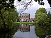 | ||
| St. Andrew Parish (nl) | Halen | Loksbergenstraat | 50°56′05″N5°04′14″E / 50.93484°N 5.07054°E | 21784 Info | 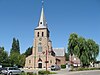 | ||
| Village house double house type (nl) | Halen | Loksbergenstraat 43 | 50°56′02″N5°04′05″E / 50.93380°N 5.06818°E | 21785 Info | |||
| Presbytery, classic double house (nl) | Halen | Loksbergenstraat 25 | 50°56′06″N5°04′15″E / 50.93498°N 5.07096°E | 21786 Info | |||
| village house (nl) | Halen | Loksbergenstraat 54 | 50°55′59″N5°04′06″E / 50.93318°N 5.06846°E | 21787 Info | |||
| Farmer Burger House, double house 1878 (nl) | Halen | Loksbergenstraat 90 | 50°55′56″N5°03′56″E / 50.93215°N 5.06568°E | 21789 Info | |||
| Semi-closed farm (nl) | Halen | Oude Leuvensebaan 3 | 50°56′03″N5°03′04″E / 50.93408°N 5.05119°E | 21790 Info | |||
| Vault Reynrode and chapel (nl) | Halen | Oude Leuvensebaan 2 | 50°56′04″N5°03′02″E / 50.93437°N 5.05059°E | 21791 Info | |||
| farm (nl) | Halen | Oude Leuvensebaan 13 | 50°56′05″N5°03′15″E / 50.93481°N 5.05430°E | 21792 Info | |||
| Rotemse mill (nl) | Halen | Gidsenstraat 24 | 50°55′44″N5°05′32″E / 50.92884°N 5.09219°E | 21794 Info |  | ||
| Abbey Mariendal, also called "Abbey Rothem" (nl) | Halen | Rotemstraat 4 | 50°55′42″N5°05′51″E / 50.92845°N 5.09759°E | 21795 Info | |||
| Farm standalone components (nl) | Halen | Rotemstraat 14 | 50°55′38″N5°05′34″E / 50.92721°N 5.09265°E | 21797 Info | |||
| St Pancras Parish Church (nl) | Halen | Kerkstraat | 50°57′39″N5°05′26″E / 50.96081°N 5.09049°E | 21798 Info |  | ||
| Presbytery classical double house (nl) | Halen | Kerkstraat 10 | 50°57′38″N5°05′27″E / 50.96055°N 5.09095°E | 21799 Info | |||
| Zelker watermill (nl) | Halen | Zelemstraat 7 | 50°57′40″N5°05′25″E / 50.96113°N 5.09015°E | 21801 Info | |||
| Parish Church Saint-Lambert (nl) | Halen | Dorpsstraat 36 | 50°58′47″N5°06′15″E / 50.97968°N 5.10423°E | 21803 Info | |||
| "Hoeve Eksterhoek" semi closed farm (nl) | Halen | Eksterhoekstraat 1 | 50°58′16″N5°05′13″E / 50.97113°N 5.08687°E | 21804 Info | |||
| "Geesthuis" double-wide house (nl) | Halen | Gennepstraat 22 | 50°59′02″N5°05′03″E / 50.98375°N 5.08426°E | 21805 Info | |||
| Men's double house Property Type (nl) | Halen | Kolenbergstraat 26 | 50°58′34″N5°05′53″E / 50.97616°N 5.09817°E | 21809 Info | |||
| Loboshoeve castle farm (nl) | Halen | Lobosstraat 2 | 50°59′00″N5°06′29″E / 50.98333°N 5.10800°E | 21810 Info | |||
| farm (nl) | Halen | Schomstraat | 50°58′21″N5°05′42″E / 50.97249°N 5.09499°E | 21811 Info | |||
| Carthusian Monastery St. Jansdal (nl) | Halen | Sint-Jansbergstraat 7-8-9 | 50°58′11″N5°05′29″E / 50.96961°N 5.09143°E | 21812 Info |  | ||
| Our Lady Chapel (nl) | Halen | Steenbergstraat | 50°58′29″N5°06′39″E / 50.97465°N 5.11085°E | 21813 Info | |||
| "Hoeve Oude Pastorij" U-shaped farm (nl) | Halen | Steenbergstraat 20 | 50°58′22″N5°05′56″E / 50.97276°N 5.09896°E | 21814 Info | |||
| "Hoeve Oude Pastorij" U-shaped farm (nl) | Halen | Steenbergstraat 22 | 50°58′22″N5°05′56″E / 50.97276°N 5.09896°E | 21814 Info | |||
| rectory (nl) | Halen | Dorpsstraat 34 | 50°58′48″N5°06′12″E / 50.97987°N 5.10325°E | 88629 Info |  | ||
| school section (nl) | Halen | Dorpsstraat 39 | 50°58′45″N5°06′16″E / 50.97905°N 5.10436°E | 88630 Info | |||
| Pan Factory "De Panoven" (nl) | Halen | Panovenstraat 45 | 50°55′52″N5°04′16″E / 50.93124°N 5.07110°E | 200349 Info | |||
| Belgian military cemetery (nl) | Halen | Liniestraat | 50°56′13″N5°05′57″E / 50.93702°N 5.09905°E | 200660 Info |  |

