This table shows an overview of the protected heritage sites in the Walloon town Houyet . This list is part of Belgium's national heritage.

Beschermd erfgoed is the official term to describe Flemish National Heritage Sites listed by law to protect and spread awareness of Belgian cultural heritage, specifically in Flanders. The term is also used nationwide to refer to national heritage sites. Because Belgium is officially a tri-lingual country, the other nationwide terms used in the rest of the country are the French term Bien classé and the German term Kulturdenkmal.

Houyet is a Walloon municipality in the Belgian province of Namur. On 1 January 2006 the municipality had 4,485 inhabitants. The total area is 122.31 km², giving a population density of 37 inhabitants per km².
| Object | Year/architect | Town/section | Address | Coordinates | Number? | Image |
|---|---|---|---|---|---|---|
| Centuries-old oak tree situated on the spot called "Petite Couture" (nl)(fr) | Houyet | 50°10′40″N5°00′56″E / 50.177639°N 5.015453°E | 91072-CLT-0002-01 Info | |||
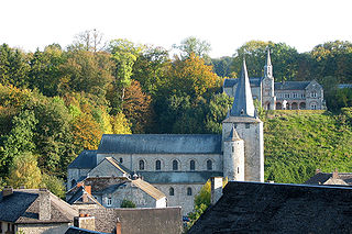
| Church of Saint Hadelin (nl)(fr) | Houyet | 50°13′44″N5°00′30″E / 50.228930°N 5.008208°E | 91072-CLT-0003-01 Info |  | ||
| Castle of Vêves (nl)(fr) | Houyet | 50°13′15″N4°58′57″E / 50.220808°N 4.982484°E | 91072-CLT-0004-01 Info | 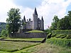 | ||
| Ensemble of the castle of Vêves and surrounding area (nl)(fr) | Houyet | 50°13′08″N4°58′37″E / 50.218861°N 4.976938°E | 91072-CLT-0005-01 Info | |||
| Tower of the Church of St. Clement (nl)(fr) | Houyet | 50°09′28″N4°56′43″E / 50.157756°N 4.945310°E | 91072-CLT-0007-01 Info | |||
| Aiguilles de Chaleux (nl)(fr) | Houyet | 50°13′18″N4°57′02″E / 50.221557°N 4.950505°E | 91072-CLT-0008-01 Info |  | ||
| Aiguilles de Chaleux: extension of the site (nl)(fr) | Houyet | 50°13′06″N4°57′04″E / 50.218322°N 4.951200°E | 91072-CLT-0009-01 Info | |||
| Chapel of Saint-Roch and the ensemble of the building and its surroundings (nl)(fr) | Houyet | 50°11′23″N5°00′15″E / 50.189790°N 5.004180°E | 91072-CLT-0010-01 Info | |||
| Totality of the chapel of Notre-Dame de Grâce and the ensemble of the chapel and its surroundings (nl)(fr) | Houyet | 50°09′13″N5°01′54″E / 50.153610°N 5.031649°E | 91072-CLT-0011-01 Info | |||
| Ensemble of the church of Saint-Hadelin except the neo-Romanesque chapel cemetery (north), the vestry and the organ (instrumental part and buffet) (nl)(fr) | Houyet | 50°13′44″N5°00′30″E / 50.228930°N 5.008208°E | 91072-PEX-0001-01 Info |  | ||
| Facades and roofs of the castle of Vêves (nl)(fr) | Houyet | 50°13′15″N4°58′57″E / 50.220808°N 4.982484°E | 91072-PEX-0002-01 Info | |||
| Aiguilles de Chaleux (nl)(fr) | Houyet | 50°13′18″N4°57′02″E / 50.221557°N 4.950505°E | 91072-PEX-0003-01 Info | |||
| Aiguilles de Chaleux: extension of the site (nl)(fr) | Houyet | 50°13′06″N4°57′04″E / 50.218322°N 4.951200°E | 91072-PEX-0004-01 Info |