List of protected heritage sites in La Roche-en-Ardenne

Last updated

This table shows an overview of the protected heritage sites in the Walloon town La Roche-en-Ardenne . This list is part of Belgium's national heritage.

Beschermd erfgoed type of heritage protection in Flanders

Beschermd erfgoed is the official term to describe Flemish National Heritage Sites listed by law to protect and spread awareness of Belgian cultural heritage, specifically in Flanders. The term is also used nationwide to refer to national heritage sites. Because Belgium is officially a tri-lingual country, the other nationwide terms used in the rest of the country are the French term Bien classé and the German term Kulturdenkmal.

La Roche-en-Ardenne Municipality in French Community, Belgium

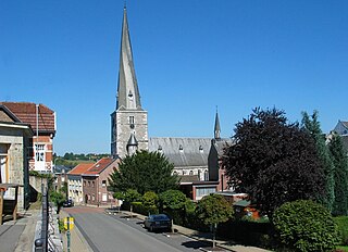
La Roche-en-Ardenne is a Walloon municipality of Belgium located in the province of Luxembourg and the arrondissement of Marche-en-Famenne. Lying beside a bend in the River Ourthe, the small town of La Roche-en-Ardenne is one of the most popular tourist destinations in the Ardennes.

Object
Year/architect
Town/section
Address
Coordinates
Number?
Image
Chapel Sainte-Marguerite (nl)(fr)
La Roche-en-Ardenne rue Sainte-Marguerite 50°11′01″N5°34′48″E / 50.183611°N 5.579932°E / 50.183611; 5.579932

83031-CLT-0001-01  Info

Old castle of La Roche-en-Ardenne (nl)(fr)
La Roche-en-Ardenne rue du Vieux Château 50°10′56″N5°34′36″E / 50.182089°N 5.576592°E / 50.182089; 5.576592

83031-CLT-0003-01  Info

Oud kasteel van La-Roche-en-Ardenne Chateau de La Roche-en-Ardenne 050518 (8).jpg
Oud kasteel van La-Roche-en-Ardenne
More images
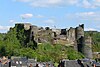
Rocky outcrop called "Les Cailloux the Mousny" (nl)(fr)
La Roche-en-Ardenne 50°06′18″N5°35′53″E / 50.104980°N 5.598165°E / 50.104980; 5.598165

83031-CLT-0004-01  Info

Fange aux Mochettes (nl)(fr)
La Roche-en-Ardenne 50°13′12″N5°39′53″E / 50.220037°N 5.664588°E / 50.220037; 5.664588

83031-CLT-0005-01  Info

Building in Cielle hamlet now a farm, including outbuildings: n ° 45 (nl)(fr)
La Roche-en-Ardenne Cielle 50°11′41″N5°33′38″E / 50.194695°N 5.560514°E / 50.194695; 5.560514

83031-CLT-0006-01  Info

Hérou site: meanders of the Ourthe: area of special value (nl)(fr)
La Roche-en-Ardenne 50°08′57″N5°38′54″E / 50.149259°N 5.648406°E / 50.149259; 5.648406

83031-CLT-0007-01  Info

Ensemble of the site Cheslé and the valley of the Ourthe between Nisramont and Naboge, and fortifications of Cheslé in Bérismenil and old trails that meander along the river Ourthe, including irrigration meadow Baltazar from the 18th century, beginning in the southern tip and along the shore and the river bed to the height of Hache. In addition, the establishment of two protected areas: Basse-zone and zone Noupre Sasseux and Les Houba. (nl)(fr)
La Roche-en-Ardenne 50°10′12″N5°38′43″E / 50.169880°N 5.645180°E / 50.169880; 5.645180

83031-CLT-0008-01  Info

Ensemble van de site Chesle en de vallei van de Ourthe tussen Nisramont en Naboge, en de versterking van de Chesle te Berismenil en oude paden die slingeren langs de meanderende Ourthe, met inbegrip van het irrigratiebereik van pre Baltazar uit de 18e eeuw, beginnende in het zuidelijke puntje en langs de oever en de rivierbedding tot aan de hoogte van Hache. Daarnaast de oprichting van twee beschermde gebieden: zone Basse-Noupre en zone Sasseux en Les Houba. Berismenil- fortification celtique-seconde enceinte.JPG
Ensemble van de site Cheslé en de vallei van de Ourthe tussen Nisramont en Naboge, en de versterking van de Cheslé te Berismenil en oude paden die slingeren langs de meanderende Ourthe, met inbegrip van het irrigratiebereik van pré Baltazar uit de 18e eeuw, beginnende in het zuidelijke puntje en langs de oever en de rivierbedding tot aan de hoogte van Hache. Daarnaast de oprichting van twee beschermde gebieden: zone Basse-Noupré en zone Sasseux en Les Houba.
More images
The mud in Mochetti (nl)(fr)
La Roche-en-Ardenne 50°13′12″N5°39′53″E / 50.220037°N 5.664588°E / 50.220037; 5.664588

83031-PEX-0001-01  Info

Ensemble of the site Cheslé and the valley of the Ourthe between Naboge and Nisramont (nl)(fr)
La Roche-en-Ardenne 50°10′12″N5°38′43″E / 50.169880°N 5.645180°E / 50.169880; 5.645180

83031-PEX-0002-01  Info

Ensemble van de site Chesle en de vallei van de Ourthe tussen Naboge en Nisramont Berismenil- fortification celtique-seconde enceinte.JPG
Ensemble van de site Cheslé en de vallei van de Ourthe tussen Naboge en Nisramont
More images
Hérou site (meanders of the Ourthe): area of special value (nl)(fr)
La Roche-en-Ardenne 50°08′57″N5°38′54″E / 50.149259°N 5.648406°E / 50.149259; 5.648406

83031-PEX-0003-01  Info

See also

Related Research Articles

World Heritage Site place listed by the UNESCO as of special cultural or natural significance

A World Heritage Site is a landmark or area which is selected by the United Nations Educational, Scientific and Cultural Organization (UNESCO) as having cultural, historical, scientific or other form of significance, and is legally protected by international treaties. The sites are judged important to the collective interests of humanity.

Wanze Municipality in French Community, Belgium

Wanze is a Walloon municipality of Belgium located in the province of Liège. It consists of the former municipalities of Wanze, Antheit, Bas-Oha, Huccorgne, Moha and Vinalmont.

Baelen Municipality in French Community, Belgium

Baelen is a Belgian municipality located in the Walloon province of Liège. On January 1, 2006, Baelen had a total population of 4,060. The total area is 85.73 km² which gives a population density of 47.36 inhabitants per km².

Bütgenbach Municipality in German-speaking Community, Belgium

Bütgenbach is a municipality located in the Belgian province of Liège. On January 1, 2006, Bütgenbach had a total population of 5,574. The total area is 97.31 km² which gives a population density of 57 inhabitants per km². As part of the German-speaking Community of Belgium, the official language in this municipality is German.

Raeren Municipality in German-speaking Community, Belgium

Raeren is a municipality located in the Belgian province of Liège. It was part of Germany until the First World War, after which it became part of Belgium. It is one of several towns in Eastern Belgium which still predominantly speak German.

Remicourt, Belgium Municipality in French Community, Belgium

Remicourt is a Walloon municipality located in the Belgian province of Liège. On January 1, 2006, Remicourt had a total population of 5,012. The total area is 22.58 km² which gives a population density of 222 inhabitants per km². It includes since 1977 the former municipalities of Momalle, Hodeige, Lamine, and Pousset.

Ferrières, Belgium Municipality in French Community, Belgium

Ferrières is a Walloon municipality located in the Belgian province of Liège. On January 1, 2006, Ferrières had a total population of 4,449. The total area is 56.90 km² with a population density of 78 inhabitants per km².

Heritage registers in Belgium cultural property of Belgium

Heritage registers in Belgium include immovable heritage such as World Heritage Sites, and National heritage sites, but also intangible cultural heritage. The agency responsible for keeping and updating inventories of immovable heritage is dependent on the region, as is the name for the object, which is called Beschermd erfgoed, Biens classés or Kulturdenkmal depending on the language of the municipality of the location.

This page is an overview of the list of protected heritage sites in Liège (province), alphabetically ordered by town name. This list is part of the national heritage of Belgium.

This page is an overview of the list of protected heritage sites in Hainaut (province), alphabetically ordered by town name. This list is part of the protected heritage sites of Belgium.

This page is an overview of the beschermd erfgoed in Luxembourg (Belgium), alphabetically ordered by town name. This list is part of the protected heritage sites of Belgium.

References