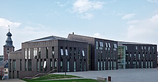
This table shows an overview of the protected heritage sites in the Walloon town Le Rœulx . This list is part of Belgium's national heritage.

Beschermd erfgoed is the official term to describe Flemish National Heritage Sites listed by law to protect and spread awareness of Belgian cultural heritage, specifically in Flanders. The term is also used nationwide to refer to national heritage sites. Because Belgium is officially a tri-lingual country, the other nationwide terms used in the rest of the country are the French term Bien classé and the German term Kulturdenkmal.

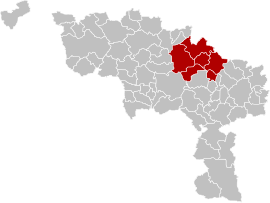
Le Rœulx is a Walloon municipality located in the Belgian province of Hainaut. On January 1, 2006, Le Rœulx had a total population of 7,977. The total area is 42.80 km² which gives a population density of 186 inhabitants per km².
| Object | Year/architect | Town/section | Address | Coordinates | Number? | Image |
|---|---|---|---|---|---|---|
| Castle of the Princes of Croÿ (nl)(fr) | Le Roeulx | place du château n°1 | 50°30′22″N4°06′35″E / 50.506076°N 4.109667°E | 55035-CLT-0001-01 Info |  | |
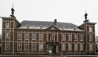
| Hospice Saint-Jacques: the main building (walls and roofs), farm and field (nl)(fr) | Le Roeulx | faubourg de Binche n°1 | 50°29′59″N4°06′32″E / 50.499703°N 4.108839°E | 55035-CLT-0003-01 Info |  | |
| Chaplain's house (Maison du Chapelain): facades and roofs (nl)(fr) | Le Roeulx | place de la Chapelle n°7 | 50°30′13″N4°06′27″E / 50.503691°N 4.107627°E | 55035-CLT-0004-01 Info | ||
| St. Martin's Church: tower (nl)(fr) | Le Roeulx | 50°31′44″N4°09′10″E / 50.528789°N 4.152664°E | 55035-CLT-0005-01 Info | |||
| Grand-Place square and house at n ° 35 (nl)(fr) | Le Roeulx | 50°30′07″N4°06′29″E / 50.501850°N 4.108169°E | 55035-CLT-0006-01 Info |  | ||
| house (nl)(fr) | Le Roeulx | Grand-Place n°35 | 50°30′06″N4°06′33″E / 50.501736°N 4.109098°E | 55035-CLT-0007-01 Info | ||
| The total orangery and the facades and roofs of the buildings of the Princes of Croÿ (nl)(fr) | Le Roeulx | 50°30′19″N4°06′31″E / 50.505180°N 4.108682°E | 55035-CLT-0008-01 Info | |||
| Chapel Notre-Dame aux Tombeaux (nl)(fr) | Le Roeulx | rue des Fours à Chaux (M). | 50°28′24″N4°04′33″E / 50.473260°N 4.075822°E | 55035-CLT-0010-01 Info |  | |
| Barges "Le Didier", "Wallon" and woods next to l'ASBL Compagnie du Canal du Centre (nl)(fr) | Le Roeulx | 50°31′35″N4°06′30″E / 50.526266°N 4.108448°E | 55035-CLT-0011-01 Info | |||
| Hydraulic lifts 1, 2, 3 and 4 located on the Canal du Centre and the bridge located between Nos. 3 and 4 and the ensemble formed by these along with the canal's banks (nl)(fr) | Le Roeulx | 50°29′15″N4°10′33″E / 50.487427°N 4.175825°E | 55035-CLT-0012-01 Info |  | ||
| The facades and roofs of the building where the engine is of the lifts No. 2 and 3 (nl)(fr) | Le Roeulx | 50°28′53″N4°08′10″E / 50.481386°N 4.136043°E | 55035-CLT-0014-01 Info | |||
| Castle of the Princes of Croÿ (nl)(fr) | Le Roeulx | 50°30′22″N4°06′35″E / 50.506076°N 4.109667°E | 55035-PEX-0001-01 Info |  | ||
| Hydraulic lifts 1, 2, 3 and 4 located on the Canal du Centre and the bridge located between Nos. 3 and 4 and the ensemble formed by these and the canal's banks (nl)(fr) | Le Roeulx | 50°29′15″N4°10′33″E / 50.487427°N 4.175825°E | 55035-PEX-0002-01 Info | 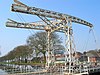 | ||
| The facades and roofs of the building where the engine of the lifts No. 2 and 3 is (nl)(fr) | Le Roeulx | 50°28′53″N4°08′10″E / 50.481386°N 4.136043°E | 55035-PEX-0003-01 Info |