List of protected heritage sites in Meix-devant-Virton

Last updated

This table shows an overview of the protected heritage sites in the Walloon town Meix-devant-Virton . This list is part of Belgium's national heritage.

Beschermd erfgoed type of heritage protection in Flanders

Beschermd erfgoed is the official term to describe Flemish National Heritage Sites listed by law to protect and spread awareness of Belgian cultural heritage, specifically in Flanders. The term is also used nationwide to refer to national heritage sites. Because Belgium is officially a tri-lingual country, the other nationwide terms used in the rest of the country are the French term Bien classé and the German term Kulturdenkmal.

Meix-devant-Virton Municipality in French Community, Belgium

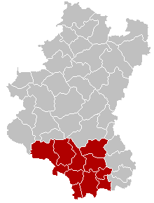
Meix-devant-Virton is a municipality of Gaume located in the Belgian province of Luxembourg. On 1 January 2017 the municipality had 2,812 inhabitants. The total area is 54.2 km², giving a population density of 54 inhabitants per km².

Object
Year/architect
Town/section
Address
Coordinates
Number?
Image
Retaining wall and fence of the cemetery of the church of Saint-Andre (nl)(fr)
Meix-devant-Virton 49°37′10″N5°25′33″E / 49.619495°N 5.425781°E / 49.619495; 5.425781

85024-CLT-0001-01  Info

Church of Saint-André and surrounding areas (nl)(fr)
Meix-devant-Virton 49°37′09″N5°25′31″E / 49.619133°N 5.425412°E / 49.619133; 5.425412

85024-CLT-0002-01  Info

Rectory of the church of Saint-André (nl)(fr)
Meix-devant-Virton Grand'Route n°9 49°37′11″N5°25′34″E / 49.619727°N 5.426037°E / 49.619727; 5.426037

85024-CLT-0003-01  Info

Oven of the church Saint-Andre (nl)(fr)
Meix-devant-Virton 49°37′11″N5°25′34″E / 49.619652°N 5.426116°E / 49.619652; 5.426116

85024-CLT-0004-01  Info

Tithe shed of the church Saint-Andre (nl)(fr)
Meix-devant-Virton Grand'Route n°9 49°37′11″N5°25′34″E / 49.619797°N 5.426214°E / 49.619797; 5.426214

85024-CLT-0005-01  Info

Church of Saint-André (nl)(fr)
Meix-devant-Virton 49°37′09″N5°25′33″E / 49.619280°N 5.425726°E / 49.619280; 5.425726

85024-CLT-0006-01  Info

Kerk Saint-Andre Gerouville JPG00.jpg
Kerk Saint-André
The ponds of Soye (nl)(fr)
Meix-devant-Virton 49°37′50″N5°25′18″E / 49.630657°N 5.421774°E / 49.630657; 5.421774

85024-CLT-0007-01  Info

Farm: facades and roofs (nl)(fr)
Meix-devant-Virton rue de la Soye n°51 49°37′03″N5°24′19″E / 49.617577°N 5.405344°E / 49.617577; 5.405344

85024-CLT-0008-01  Info

House: facades and roofs, and wall of the orchard (nl)(fr)
Meix-devant-Virton Place du Tilleul n° 21 49°37′14″N5°25′42″E / 49.620447°N 5.428412°E / 49.620447; 5.428412

85024-CLT-0009-01  Info

Building: façade and the entire roof (nl)(fr)
Meix-devant-Virton Grand' Rue n° 37 49°35′43″N5°30′27″E / 49.595402°N 5.507581°E / 49.595402; 5.507581

85024-CLT-0010-01  Info

House: entrance of the main building, including the niche (nl)(fr)
Meix-devant-Virton place de l'Eglise n° 105 49°37′08″N5°25′29″E / 49.618804°N 5.424740°E / 49.618804; 5.424740

85024-CLT-0011-01  Info

Farm: front facades and roof (nl)(fr)
Meix-devant-Virton Petite rue n°160 49°37′06″N5°25′37″E / 49.618357°N 5.426911°E / 49.618357; 5.426911

85024-CLT-0012-01  Info

Farm: facades and roofs (nl)(fr)
Meix-devant-Virton Rue du centre n° 69 49°34′29″N5°28′47″E / 49.574678°N 5.479786°E / 49.574678; 5.479786

85024-CLT-0013-01  Info

Facades and roofs, rear yard and the retaining wall and paved area for the old public wash house (nl)(fr)
Meix-devant-Virton rue Gérouville 28 49°36′18″N5°28′41″E / 49.604893°N 5.478073°E / 49.604893; 5.478073

85024-CLT-0014-01  Info

See also

Related Research Articles

World Heritage Site place listed by the UNESCO as of special cultural or natural significance

A World Heritage Site is a landmark or area which is selected by the United Nations Educational, Scientific and Cultural Organization (UNESCO) as having cultural, historical, scientific or other form of significance, and is legally protected by international treaties. The sites are judged important to the collective interests of humanity.

Meurthe-et-Moselle Department of France

Meurthe-et-Moselle is a department in the Grand Est region of France, named after the Meurthe and Moselle rivers.

Bertrix Municipality in French Community, Belgium

Bertrix is a Walloon municipality of Belgium located in the province of Luxembourg. On 1 January 2007 the municipality, which covers 137.7 km², had 8,164 inhabitants, giving a population density of 59.3 inhabitants per km².

Florenville Municipality in French Community, Belgium

Florenville is a Walloon municipality located in the Belgian province of Luxembourg. On 1 January 2016 the municipality had 5,639 inhabitants. The total area is 146.91 km², giving a population density of 38.38 inhabitants per km².

Tintigny Municipality in French Community, Belgium

Tintigny is a Walloon municipality located in the Virton arrondissement in the Belgian province of Luxembourg. On 1 January 2015 the municipality had 4,200 inhabitants. Its total area is 81.79 km², giving it a population density of 45.7 inhabitants per km².

Virton Municipality in French Community, Belgium

Virton is a Walloon municipality located in the Belgian province of Luxembourg. It is also the administrative centre of the district (arrondissement) of the same name, as well as the principal town of the small region of Belgian Lorraine known as the Gaume, famous for its microclimate.

Gaume cultural region in Belgium and France

Gaume is a region in the extreme southeast of Belgium. At a lower altitude than the Ardennes, it borders the French region of Lorraine to the south, the Land of Arlon to the east the Belgian part of the Ardennes to the north.

R.E. Virton association football club in Belgium

Royal Excelsior Virton is a Belgian football club, from the city of Virton in Luxembourg province.

Arrondissement of Virton Arrondissement in Wallonia, Belgium

The Arrondissement of Virton is one of the five administrative arrondissements in the Province of Luxembourg, Belgium.

Thierry Siquet is a Belgian retired professional football defender, who is the manager of Belgium U17 and the technical director of Virton.

Heritage registers in Belgium cultural property of Belgium

Heritage registers in Belgium include immovable heritage such as World Heritage Sites, and National heritage sites, but also intangible cultural heritage. The agency responsible for keeping and updating inventories of immovable heritage is dependent on the region, as is the name for the object, which is called Beschermd erfgoed, Biens classés or Kulturdenkmal depending on the language of the municipality of the location.

This page is an overview of the list of protected heritage sites in Liège (province), alphabetically ordered by town name. This list is part of the national heritage of Belgium.

This page is an overview of the list of protected heritage sites in Hainaut (province), alphabetically ordered by town name. This list is part of the protected heritage sites of Belgium.

Robelmont Place in Walloon Region, Belgium

Robelmont is a historic village in the Belgian province of Luxembourg, part of the municipality of Meix-devant-Virton since 1977. The asteroid 1145 Robelmonte is named after the village, in honour of the astronomer Sylvain Arend (1902–1992), who was born there.

Gaume Natural Park

Gaume Natural Park is a natural park situated in Gaume, in the Province of Luxembourg, Belgium. It was created on 18 December 2014 by the Walloon government. Covering 58104 ha, it is composed of several municipalities: Aubange, Etalle, Florenville, Meix-devant-Virton, Musson, Rouvroy, Saint-Léger, Tintigny and Virton.

The 2018–19 Belgian Third Amateur Division is the third season of the division in its current format, replacing the former Belgian Fourth Division.

References