This table shows an overview of the protected heritage sites in the Walloon town Messancy . This list is part of Belgium's national heritage.

Beschermd erfgoed is the official term to describe Flemish National Heritage Sites listed by law to protect and spread awareness of Belgian cultural heritage, specifically in Flanders. The term is also used nationwide to refer to national heritage sites. Because Belgium is officially a tri-lingual country, the other nationwide terms used in the rest of the country are the French term Bien classé and the German term Kulturdenkmal.

Messancy is a Walloon municipality of Belgium located in the province of Luxembourg. On 1 January 2007 the municipality, which covers 52.43 km², had 7,466 inhabitants, giving a population density of 142.4 inhabitants per km².
| Object | Year/architect | Town/section | Address | Coordinates | Number? | Image |
|---|---|---|---|---|---|---|
| Calvary (see Stations of the cross), next to the building No. 83 (nl)(fr) | Messancy | rue Albert Ier, Buvange | 49°37′34″N5°47′56″E / 49.626163°N 5.798989°E | 81015-CLT-0001-01 Info |  | |
| Calvary Saint-Nicolas, in the middle of the intersection of the streets and rue des Rochers Theisen in Hondelange (nl)(fr) | Messancy | 49°38′00″N5°50′03″E / 49.633306°N 5.834197°E | 81015-CLT-0002-01 Info | |||
| Four calvaries: remains of a seven-station procession path with stations of the cross (nl)(fr) | Messancy | Wolkrange | 49°37′56″N5°48′13″E / 49.632223°N 5.803573°E | 81015-CLT-0003-01 Info | 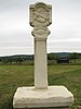 | |
| Calvary, at the corner of the roads rue Concordia and rue des Bles d'Or (nl)(fr) | Messancy | 49°38′01″N5°49′56″E / 49.633639°N 5.832274°E | 81015-CLT-0004-01 Info | |||
| Calvary (nl)(fr) | Messancy | rue Concardia face au n°11 | 49°38′00″N5°49′54″E / 49.633205°N 5.831605°E | 81015-CLT-0005-01 Info |  | |
| Calvary (nl)(fr) | Messancy | rue de la Chapelle | 49°38′03″N5°49′43″E / 49.634154°N 5.828580°E | 81015-CLT-0006-01 Info | ||
| Calvary, at the corner of the roads rue Concordia and rue de la Chapelle (nl)(fr) | Messancy | 49°37′59″N5°49′52″E / 49.633088°N 5.831177°E | 81015-CLT-0007-01 Info | 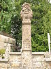 | ||
| Calvary (nl)(fr) | Messancy | rue de la Chapelle, face au n°64 | 49°38′07″N5°49′26″E / 49.635233°N 5.823831°E | 81015-CLT-0008-01 Info | ||
| Calvary near the chapel of Sainte-Croix (nl)(fr) | Messancy | rue de la chapelle | 49°38′08″N5°49′13″E / 49.635533°N 5.820216°E | 81015-CLT-0009-01 Info |  | |
| Calvary (nl)(fr) | Messancy | rue de la Chapelle, op de gevel van n°24 | 49°38′08″N5°49′07″E / 49.635479°N 5.818558°E | 81015-CLT-0010-01 Info |  | |
| Calvary at the front of the church (nl)(fr) | Messancy | Habergy | 49°36′52″N5°45′33″E / 49.614370°N 5.759050°E | 81015-CLT-0011-01 Info |  | |
| Calvary of Trinité (nl)(fr) | Messancy | rue de la Halte, Turpange | 49°36′43″N5°49′08″E / 49.611827°N 5.818930°E | 81015-CLT-0012-01 Info | 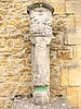 | |
| Calvary (nl)(fr) | Messancy | rue Neuve | 49°35′38″N5°48′58″E / 49.593884°N 5.816155°E | 81015-CLT-0013-01 Info | 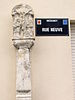 | |
| Calvary located at the front of the house located at Grand Rue 56, in the beginning of the Rue de la Trinité (nl)(fr) | Messancy | 49°35′34″N5°48′54″E / 49.592643°N 5.815114°E | 81015-CLT-0014-01 Info |  | ||
| Calvary leaning against the right side of the wall of the room Concordia (nl)(fr) | Messancy | rue des Chasseurs Ardennais | 49°35′35″N5°48′58″E / 49.592947°N 5.816191°E | 81015-CLT-0015-01 Info |  | |
| Calvary in Longeau (located at the intersection of the roads to Guerlange and to Longeau) (nl)(fr) | Messancy | 49°34′49″N5°50′29″E / 49.580155°N 5.841327°E | 81015-CLT-0016-01 Info |  | ||
| Calvary located on the island in Longeau formed by the road that leads to Clemency and the road to Longeau when leaving the village Selange (nl)(fr) | Messancy | 49°36′14″N5°51′13″E / 49.603841°N 5.853642°E | 81015-CLT-0017-01 Info | 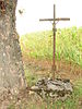 |


