This table shows an overview of the protected heritage sites in the Walloon town Paliseul . This list is part of Belgium's national heritage.

Beschermd erfgoed is the official term to describe Flemish National Heritage Sites listed by law to protect and spread awareness of Belgian cultural heritage, specifically in Flanders. The term is also used nationwide to refer to national heritage sites. Because Belgium is officially a tri-lingual country, the other nationwide terms used in the rest of the country are the French term Bien classé and the German term Kulturdenkmal.

Paliseul is a Walloon municipality of Belgium located in the province of Luxembourg. On 1 January 2007 the municipality, which covers 112.96 km², had 5,055 inhabitants, giving a population density of 44.8 inhabitants per km².
| Object | Year/architect | Town/section | Address | Coordinates | Number? | Image |
|---|---|---|---|---|---|---|
| Forest Houmont (nl)(fr) | Paliseul | 49°57′29″N5°10′22″E / 49.958030°N 5.172884°E | 84050-CLT-0001-01 Info | |||
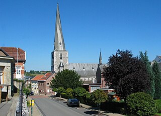
| Church of Saint Remacle (nl)(fr) | Paliseul | 49°56′04″N5°07′07″E / 49.934428°N 5.118593°E | 84050-CLT-0003-01 Info | |||
| Establishment of conservation around the church Saint-Remacle (nl)(fr) | Paliseul | 49°56′02″N5°07′07″E / 49.934004°N 5.118563°E | 84050-CLT-0004-01 Info | |||
| Church of Saint-Laurent: facades and roofs (nl)(fr) | Paliseul | Our | 49°57′35″N5°07′25″E / 49.959692°N 5.123496°E | 84050-CLT-0005-01 Info |  | |
| Cemetery wall and stairs to the cemetery around the church of Saint-Laurent and the ensemble of the church, the cemetery and lawn located between the wall of the cemetery and roads, including the slope along the rue Porcheresse. Establishment of a protection zone limited to the facades of the buildings in the streets around the church and bridge across the Our. (nl)(fr) | Paliseul | Our | 49°57′35″N5°07′25″E / 49.959586°N 5.123505°E | 84050-CLT-0006-01 Info | | |
| Chapel of Saint-Roch and the surrounding wall (nl)(fr) | Paliseul | rue Saint-Roch | 49°54′16″N5°08′22″E / 49.904422°N 5.139379°E | 84050-CLT-0007-01 Info |  | |
| Marie-Thérèse bridge west of the mill of Wes-el-Vaux and the ensemble of the bridge and its surroundings (nl)(fr) | Paliseul | 49°58′26″N5°11′20″E / 49.973953°N 5.188851°E | 84050-CLT-0008-01 Info |  | ||
| Bridge of Justice "Pont Vieux" and the ensemble of the bridge and its surroundings (nl)(fr) | Paliseul | 49°57′59″N5°11′38″E / 49.966404°N 5.193831°E | 84050-CLT-0009-01 Info |  | ||
| Beth bridge across the Our River and the ensemble of the bridge and its surroundings (nl)(fr) | Paliseul | Beth | 49°56′37″N5°07′22″E / 49.943669°N 5.122906°E | 84050-CLT-0010-01 Info |