This table shows an overview of the protected heritage sites in the Walloon town Rouvroy, Belgium . This list is part of Belgium's national heritage.

Beschermd erfgoed is the official term to describe Flemish National Heritage Sites listed by law to protect and spread awareness of Belgian cultural heritage, specifically in Flanders. The term is also used nationwide to refer to national heritage sites. Because Belgium is officially a tri-lingual country, the other nationwide terms used in the rest of the country are the French term Bien classé and the German term Kulturdenkmal.

Rouvroy is a Walloon municipality of Belgium located in the province of Luxembourg. On 1 January 2007 the municipality, which covers 27.68 km², had 2,007 inhabitants, giving a population density of 72.5 inhabitants per km². Belgium's southernmost point is situated in the municipality, at Torgny.
| Object | Year/architect | Town/section | Address | Coordinates | Number? | Image |
|---|---|---|---|---|---|---|
| Church of Saint-Quentin (nl)(fr) | Rouvroy | Montquintin | 49°32′42″N5°28′26″E / 49.544904°N 5.473813°E | 85047-CLT-0002-01 Info | 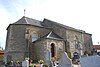 | |
| Ruins of castle Dampicourt (nl)(fr) | Rouvroy | 49°32′44″N5°28′22″E / 49.545587°N 5.472679°E | 85047-CLT-0003-01 Info |  | ||
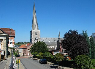
| Entire site of Montquintin (nl)(fr) | Rouvroy | 49°32′44″N5°28′21″E / 49.545569°N 5.472382°E | 85047-CLT-0004-01 Info | | ||
| Manor farm of the castle (facades and roofs), all of the dovecote and the surrounding wall (nl)(fr) | Rouvroy | rue du Château fort, n°12 | 49°32′41″N5°28′23″E / 49.544774°N 5.472941°E | 85047-CLT-0005-01 Info | ||
| Museum of Rural Life, historical museum (nl)(fr) | Rouvroy | place Montseigneur de Hontheim | 49°32′41″N5°28′24″E / 49.544774°N 5.473380°E | 85047-CLT-0006-01 Info |  | |
| St. Martin's Church: tower (nl)(fr) | Rouvroy | 49°32′18″N5°29′29″E / 49.538307°N 5.491373°E | 85047-CLT-0007-01 Info | |||
| farm (nl)(fr) | Rouvroy | rue Péchières, n°6 | 49°30′33″N5°28′25″E / 49.509174°N 5.473718°E | 85047-CLT-0009-01 Info | ||
| Nature reserve of Raymond Mayné (nl)(fr) | Rouvroy | 49°30′40″N5°28′43″E / 49.511115°N 5.478620°E | 85047-CLT-0011-01 Info | |||
| Ensemble of Chapel of Notre-Dame de Luxembourg, the refuge area (nl)(fr) | Rouvroy | rue de l'Ermitage | 49°30′32″N5°28′56″E / 49.508798°N 5.482190°E | 85047-CLT-0013-01 Info | ||
| Farm (facades and roofs) (nl)(fr) | Rouvroy | rue de Mathon, n°21 | 49°33′15″N5°29′59″E / 49.554305°N 5.499776°E | 85047-CLT-0014-01 Info | ||
| Washing place (nl)(fr) | Rouvroy | rue Grande | 49°30′29″N5°28′27″E / 49.508106°N 5.474168°E | 85047-CLT-0015-01 Info | ||
| House (nl)(fr) | Rouvroy | rue Jean, n°15 | 49°30′23″N5°28′23″E / 49.506310°N 5.473180°E | 85047-CLT-0016-01 Info | ||
| Area Montquintin (area of special value) (nl)(fr) | Rouvroy | 49°32′44″N5°28′21″E / 49.545569°N 5.472382°E | 85047-PEX-0001-01 Info |  |