This table shows an overview of the protected heritage sites in the Walloon town Opzullik, or Silly, Belgium . This list is part of Belgium's national heritage.

Beschermd erfgoed is the official term to describe Flemish National Heritage Sites listed by law to protect and spread awareness of Belgian cultural heritage, specifically in Flanders. The term is also used nationwide to refer to national heritage sites. Because Belgium is officially a tri-lingual country, the other nationwide terms used in the rest of the country are the French term Bien classé and the German term Kulturdenkmal.

Silly is a Walloon municipality located in the Belgian province of Hainaut. On January 1, 2006, Silly had a total population of 7,995. The total area is 67.68 square kilometres (26.13 sq mi) which gives a population density of 118 inhabitants per km².
| Object | Year/architect | Town/section | Address | Coordinates | Number? | Image |
|---|---|---|---|---|---|---|
| Valley on the southwest edge of the forest Cambron at a place called "L'Ermitage" (nl)(fr) | Opzullik | Silly | 50°37′16″N3°57′44″E / 50.621160°N 3.962099°E | 55039-CLT-0002-01 Info | ||
| The oldest parts, namely the ship, the nave and the tower of the church of Bassilly and the ensemble of this church, the cemetery, the avenue of lime trees and the enclosing wall (nl)(fr) | Opzullik | 50°40′22″N3°56′11″E / 50.672705°N 3.936459°E | 55039-CLT-0003-01 Info | |||
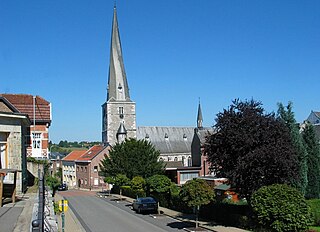
| Church of Saint-Amand (nl)(fr) | Opzullik | Hellebecq | 50°39′47″N3°53′20″E / 50.663181°N 3.889000°E | 55039-CLT-0004-01 Info |  | |
| the church of St. Maurice (nl)(fr) | Opzullik | Hoves | 50°40′14″N4°02′07″E / 50.670622°N 4.035146°E | 55039-CLT-0005-01 Info |  | |
| Site formed by the church of Saint-Maurice, the cemetery and the old wall that surrounds this (nl)(fr) | Opzullik | Hoves | 50°40′13″N4°02′05″E / 50.670280°N 4.034588°E | 55039-CLT-0006-01 Info |  | |
| The motte located near the castle and the church of Silly (nl)(fr) | Opzullik | 50°40′15″N4°02′05″E / 50.670716°N 4.034790°E | 55039-CLT-0007-01 Info | |||
| The facade and roof of the castle of Thoricourt, outbuildings and orangerie, interior and exterior of the chapel, the pillory (M) and the ensemble of the castle and surrounding park (nl)(fr) | Opzullik | 50°37′02″N3°57′11″E / 50.617151°N 3.952994°E | 55039-CLT-0008-01 Info |  | ||
| Tower of the castle of Launois (nl)(fr) | Opzullik | Silly | 50°36′51″N3°57′34″E / 50.614259°N 3.959369°E | 55039-CLT-0010-01 Info | ||
| The old buildings at the entrance to the grounds of the castle of Enghien, including the old stables, pavilion Edward, the door of the slaves, the chapel and the pavilion called "Pavillon des Sept Etoiles" and the ensemble of the castle , the outbuildings and the adjacent land (nl)(fr) | Opzullik | 50°41′32″N4°02′27″E / 50.692184°N 4.040844°E | 55039-CLT-0013-01 Info | |||
| The Pavillon des Sept Etoiles and the park of Arenberg castle, except the golf course (nl)(fr) | Opzullik | 50°41′16″N4°02′50″E / 50.687656°N 4.047325°E | 55039-PEX-0001-01 Info |