This table shows an overview of the protected heritage sites in the Walloon town Viroinval . This list is part of Belgium's national heritage.

Beschermd erfgoed is the official term to describe Flemish National Heritage Sites listed by law to protect and spread awareness of Belgian cultural heritage, specifically in Flanders. The term is also used nationwide to refer to national heritage sites. Because Belgium is officially a tri-lingual country, the other nationwide terms used in the rest of the country are the French term Bien classé and the German term Kulturdenkmal.

Viroinval is a Walloon municipality located in Belgium in the province of Namur. On January 1, 2006 Viroinval had a total population of 5,680. The total area is 120.90 km² which gives a population density of 47 inhabitants per km².
| Object | Year/architect | Town/section | Address | Coordinates | Number? | Image |
|---|---|---|---|---|---|---|
| The site of "Roche à Lomme", the "Montagne-au-tube" and the "au Tienne Pauquis" (nl)(fr) | Dourbes Viroinval | 50°05′23″N4°32′27″E / 50.089822°N 4.540941°E | 93090-CLT-0004-01 Info | |||
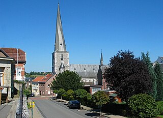
| Church of Saint-Servais, the ensemble of the church, the cemetery surrounded by a wall (nl)(fr) | Viroinval | Dourbes | 50°05′19″N4°35′36″E / 50.088547°N 4.593262°E | 93090-CLT-0006-01 Info |  | |
| Old castle ruins of the "Pont d'Avignon" (nl)(fr) | Viroinval | Nismes | 50°04′27″N4°32′48″E / 50.074169°N 4.546584°E | 93090-CLT-0009-01 Info |  | |
| Chapel of Saint Joseph and the building and its surroundings (nl)(fr) | Viroinval | Viroinval | 50°03′49″N4°33′06″E / 50.063653°N 4.551768°E | 93090-CLT-0011-01 Info | ||
| House of Bailli (nl)(fr) | Viroinval | Nismes | 50°04′27″N4°32′49″E / 50.074139°N 4.546960°E | 93090-CLT-0012-01 Info |  | |
| Chapel of Saint-Roch (nl)(fr) | Viroinval | Viroinval | 50°04′45″N4°33′00″E / 50.079083°N 4.549970°E | 93090-CLT-0013-01 Info | ||
| Valley Viroin (nl)(fr) | Mazée Viroinval | 50°04′25″N4°38′07″E / 50.073617°N 4.635292°E | 93090-CLT-0016-01 Info | 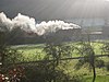 | ||
| Chapel of Saint-Roch and the ensemble of the chapel and its surroundings (nl)(fr) | Viroinval | Mazée | 50°06′09″N4°42′13″E / 50.102573°N 4.703511°E | 93090-CLT-0017-01 Info |  | |
| Totality of the old washing place and the ensemble of these, with the chapel and the site of the triangular forest (nl)(fr) | Vierves-sur-Viroin Viroinval | Vierves | 50°04′49″N4°37′54″E / 50.080371°N 4.631772°E | 93090-CLT-0018-01 Info | ||
| The castle and the outer wall of limestone and the ensemble of the farm and its surroundings (nl)(fr) | Treignes Viroinval | Treignes | 50°05′35″N4°40′11″E / 50.093125°N 4.669833°E | 93090-CLT-0019-01 Info | 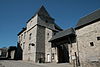 | |
| Totality of the main building and the keep of the castle of Treignes (nl)(fr) | Treignes Viroinval | 50°05′35″N4°40′11″E / 50.092926°N 4.669648°E | 93090-CLT-0020-01 Info | |||
| Fond du Ry (nl)(fr) | Treignes Viroinval | Treignes | 50°05′39″N4°40′13″E / 50.094175°N 4.670187°E | 93090-CLT-0021-01 Info | ||
| Old bridge over the Viroin, and the ensemble of the bridge and the surrounding areas, namely the river and its banks over a hundred meters upstream and downstream (nl)(fr) | Treignes Viroinval | Treignes | 50°05′28″N4°40′13″E / 50.091233°N 4.670322°E | 93090-CLT-0022-01 Info |  | |
| Ensemble of the site of Walleu (nl)(fr) | Dourbes Viroinval | Dourbes | 50°04′36″N4°34′52″E / 50.076606°N 4.581095°E | 93090-CLT-0023-01 Info | ||
| Ensemble of the Fondry des Chiens and the limestone lawn of Tienne Sainte-Anne, which borders it (nl)(fr) | Viroinval | 50°04′02″N4°33′13″E / 50.067263°N 4.553602°E | 93090-CLT-0024-01 Info |  | ||
| The site of "Roche à Lomme", the "Montagne-au-tube" and the "au Tienne Pauquis" (nl)(fr) | Viroinval | 50°05′23″N4°32′27″E / 50.089822°N 4.540941°E | 93090-PEX-0001-01 Info | |||
| Ensemble of the Fondry des Chien and the limestone lawn of Tienne Sainte-Anne, which it borders (nl)(fr) | Viroinval | 50°04′02″N4°33′13″E / 50.067263°N 4.553602°E | 93090-PEX-0002-01 Info |  |