This table shows an overview of the protected heritage sites in the Walloon town Étalle, Belgium . This list is part of Belgium's national heritage.
Beschermd erfgoed is the official term to describe Flemish National Heritage Sites listed by law to protect and spread awareness of Belgian cultural heritage, specifically in Flanders. The term is also used nationwide to refer to national heritage sites. Because Belgium is officially a tri-lingual country, the other nationwide terms used in the rest of the country are the French term Bien classé and the German term Kulturdenkmal.
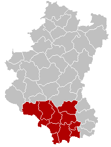
Étalle is a Walloon municipality of Belgium located in the province of Luxembourg. On 1 January 2007 the municipality, which covers 78.1 km², had 5,389 inhabitants, giving a population density of 69 inhabitants per km².
Object | Year/architect | Town/section | Address | Coordinates | Number? | Image |
---|---|---|---|---|---|---|
Ancient fortified ruins of the refuge and covered halls of the old ironworks from the 17th century and the ensemble of the listed buildings and the immediate vicinity of the former Roman camp (nl)(fr) | Etalle | 49°37′51″N5°35′42″E / 49.630729°N 5.594953°E | 85009-CLT-0001-01 Info | |||
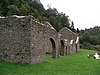
St. Martin's Church (nl)(fr) | Etalle | 49°41′59″N5°33′40″E / 49.699785°N 5.561089°E | 85009-CLT-0002-01 Info | |||
Washing place near the church Saint-Martin (nl)(fr) | Etalle | rue Saint-Martin | 49°41′59″N5°33′39″E / 49.699717°N 5.560804°E | 85009-CLT-0003-01 Info | ||
pump (nl)(fr) | Etalle | rue du Marais | 49°40′18″N5°33′53″E / 49.671532°N 5.564859°E | 85009-CLT-0004-01 Info | ||
pump (nl)(fr) | Etalle | Place Communale, Etalle | 49°40′26″N5°33′50″E / 49.673784°N 5.563959°E | 85009-CLT-0005-01 Info | ||
pump (nl)(fr) | Etalle | chaussée Romaine | 49°40′11″N5°33′50″E / 49.669677°N 5.563839°E | 85009-CLT-0006-01 Info | ||
Washing place (nl)(fr) | Etalle | route de Mortinsart | 49°42′15″N5°35′07″E / 49.704218°N 5.585335°E | 85009-CLT-0007-01 Info | ||
Linden tree near the church (nl)(fr) | Etalle | place Saint-Michel | 49°39′11″N5°39′04″E / 49.653157°N 5.651151°E | 85009-CLT-0008-01 Info | More images | |
Avenue with 36 lime trees at the exit of Chantemelle (nl)(fr) | Etalle | 49°38′59″N5°39′05″E / 49.649811°N 5.651409°E | 85009-CLT-0009-01 Info | |||
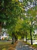
The heraldic shield with the coat of arms of Semois (nl)(fr) | Etalle | 49°41′17″N5°33′05″E / 49.687928°N 5.551508°E | 85009-CLT-0010-01 Info | |||
Marsh called "du Landbrough" and environment (nl)(fr) | Etalle | 49°39′17″N5°41′01″E / 49.654740°N 5.683657°E | 85009-CLT-0011-01 Info | |||
Ensemble of the archaeological site of the old ironworks of Buzenol (nl)(fr) | Etalle | 49°37′49″N5°35′30″E / 49.630322°N 5.591735°E | 85009-PEX-0001-01 Info | More images | ||
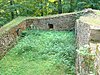
Marsh called "du Landbrough" (nl)(fr) | Etalle | 49°39′17″N5°41′01″E / 49.654740°N 5.683657°E | 85009-PEX-0002-01 Info |
Wikimedia Commons has media related to Cultural heritage monuments in Étalle, Belgium . |
A World Heritage Site is a landmark or area which is selected by the United Nations Educational, Scientific and Cultural Organization (UNESCO) as having cultural, historical, scientific or other form of significance, and is legally protected by international treaties. The sites are judged important to the collective interests of humanity.
Wanze is a Walloon municipality of Belgium located in the province of Liège. It consists of the former municipalities of Wanze, Antheit, Bas-Oha, Huccorgne, Moha and Vinalmont.
Bütgenbach is a municipality located in the Belgian province of Liège. On January 1, 2006, Bütgenbach had a total population of 5,574. The total area is 97.31 km² which gives a population density of 57 inhabitants per km². As part of the German-speaking Community of Belgium, the official language in this municipality is German.
Raeren is a municipality located in the Belgian province of Liège. It was part of Germany until the First World War, after which it became part of Belgium. It is one of several towns in Eastern Belgium which still predominantly speak German.
Remicourt is a Walloon municipality located in the Belgian province of Liège. On January 1, 2006, Remicourt had a total population of 5,012. The total area is 22.58 km² which gives a population density of 222 inhabitants per km². It includes since 1977 the former municipalities of Momalle, Hodeige, Lamine, and Pousset.
Ferrières is a Walloon municipality located in the Belgian province of Liège. On January 1, 2006, Ferrières had a total population of 4,449. The total area is 56.90 km² with a population density of 78 inhabitants per km².
The Arrondissement of Virton is one of the five administrative arrondissements in the Province of Luxembourg, Belgium.
Villers-sur-Semois Castle is a castle in Villers-sur-Semois in the municipality of Étalle in the province of Luxembourg, Belgium.
Heritage registers in Belgium include immovable heritage such as World Heritage Sites, and National heritage sites, but also intangible cultural heritage. The agency responsible for keeping and updating inventories of immovable heritage is dependent on the region, as is the name for the object, which is called Beschermd erfgoed, Biens classés or Kulturdenkmal depending on the language of the municipality of the location.
This page is an overview of the list of protected heritage sites in Liège (province), alphabetically ordered by town name. This list is part of the national heritage of Belgium.
This page is an overview of the list of protected heritage sites in Hainaut (province), alphabetically ordered by town name. This list is part of the protected heritage sites of Belgium.
This page is an overview of the beschermd erfgoed in Luxembourg (Belgium), alphabetically ordered by town name. This list is part of the protected heritage sites of Belgium.