The Krishna River is the fourth-largest river in terms of water inflows and river basin area in India, after the Ganga, Godavari and Brahmaputra. The river, also called Krishnaveni, is almost 1,288 kilometres (800 mi) long. It is a major source of irrigation for Maharashtra, Karnataka, Telangana and Andhra Pradesh.

Coastal Andhra is a region in the state of Andhra Pradesh, India. It was part of Madras State before 1953 and Andhra State from 1953 to 1956. According to the 2011 census, it has an area of 95,442 square kilometres (36,850 sq mi) which is 57.99% of the total state area and a population of 34,193,868 which is 69.20% of Andhra Pradesh state population. This area includes the coastal districts of Andhra Pradesh on the Coromandel Coast between the Eastern Ghats and the Bay of Bengal, from the northern border with Odisha to Pulicat lake in the South.
Amaravathi is a city on the banks of the Krishna River, in the Guntur district of the Indian state of Andhra Pradesh. It is the headquarters of Amaravathi mandal, and forms part of the Andhra Pradesh Capital Region with its headquarters at new Amaravati 35 km (22 mi) east, whose name is also borrowed from that of the older Amaravathi.

Guntur district is one of the nine districts in the Coastal Andhra region of the Indian state of Andhra Pradesh. The administrative seat of the district is located at Guntur, the largest city of the district in terms of area and with a population of 670,073. It has a coastline of approximately 100 km (62 mi) on the right bank of Krishna River, that separates it from Krishna district and extends till it empties into the Bay of Bengal. It is bounded on the south by Prakasam district and on the west by the state of Telangana. It has an area of 11,391 km2 (4,398 sq mi) and is the 2nd most populous district in the state, with a population of 4,889,230 as per 2011 census of India.

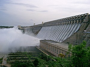
Nagarjuna Sagar Dam is a masonry dam across the Krishna River at Nagarjuna Sagar which straddles the border between Nalgonda district in Telangana and Guntur district in Andhra Pradesh. The dam provides irrigation water to the Nalgonda, Suryapet, Krishna, Khammam, West Godavari, Guntur, and Prakasam districts along with electricity generation.

Markapur is a town in Prakasam district of the Indian state of Andhra Pradesh. It is a municipality and the headquarters of Markapur mandal in Markapur revenue division. Markapur is known for the Chennakesava Swamy Temple built by King Sri Krishnadevaraya, one of the oldest temples in the state. A carnival happens every year during Ratha yatra. It is also famous for Chenna Kesavaswamy Saptavahana Seva on the day of Rathsapthami during which the lord will be taken to procession on a Vendi Ratham, which is attended by thousands of people coming from different parts of the state. It is third-largest town in Prakasam district after Ongole and Chirala, and it is main place for West Prakasam district to avail all facilities.

Bhattiprolu is a village in Guntur district of the Indian state of Andhra Pradesh. It is the headquarters of Bhattiprolu mandal in Tenali revenue division. The Buddhist stupa in the village is one of the centrally protected monuments of national importance. One of the earliest evidence of Brahmi script in South India comes from Bhattiprolu. The script was written on an urn containing Buddha's relics. The script has been named Bhattiprolu script
This gives a timeline of major and important events that took place in the Guntur region of India.

Nagarjunakonda is a historical town, now an island located near Nagarjuna Sagar in Guntur district of the Indian state of Andhra Pradesh, near the state border with Telangana. It is 160 km west of another important historic site Amaravati Stupa.

The Undavalli Caves, a monolithic example of Indian rock-cut architecture and one of the finest testimonials to ancient viswakarma sthapathis, are located in Undavalli of Guntur district in the Indian state of Andhra Pradesh. The caves are located 6 km south west from Vijayawada, 22 km north east of Guntur City of Andhra Pradesh. It is one of the centrally protected monuments of national importance.

Andhra Pradesh is a state in India. Andhra Pradesh Tourism Development Corporation (APTDC) is a state government agency which promotes tourism in Andhra Pradesh, describing the state as the Koh-i-Noor of India. Andhra Pradesh has a variety of tourist attractions including beaches, hills, caves, wildlife, forests and temples.

Kondaveedu Fort is a historically significant ancient hill fortress located in Kondaveedu, a village in the Chilakaluripet constituency of Guntur district, Andhra Pradesh, India. The site is located 16 miles west of the city of Guntur. Apart from this main fort, there are two other forts nearby. Efforts are in progress to classify Kondaveedu Fort as a UNESCO World Heritage Site.

Ethipothala Falls is a 70 feet (21 m) high river cascade, situated in Guntur district, Andhra Pradesh, India. Located on the Chandravanka river, which is a tributary of River Krishna joining on its right bank. The waterfall is a combination of three streams namely Chandravanka Vagu, Nakkala Vagu and Tummala Vagu. It is situated about 11 kilometres (6.8 mi) from Nagarjuna Sagar Dam. The river then joins the Krishna river after the dam after travelling about 3 kilometres (1.9 mi) from the falls. A strategic view point was created by the Andhra Pradesh Tourism Department from the adjacent hillock. There is a crocodile breeding centre in the pond formed by the waterfall. Water from the Nagarjuna Sagar right bank canal is released in to the above streams to keep the waterfall alive and flowing throughout the year for tourism purposes.
Religion and spirituality, a pilgrimage is a long journey or search of great moral significance. Sometimes, it is a journey to a sacred place or shrine of importance to a person's beliefs and faith. Members of every major religion participate in pilgrimages. A person who makes such a journey is called a pilgrim.

Pulichintala Project is a multipurpose project serving irrigation needs, hydro power generation and flood control. It is a crucial irrigation facility for farmers of four coastal districts of West Godavari, Krishna, Guntur and Prakasam where irrigation facility for 13 lakh acres. It has 24 gates in all with balancing reservoir with a capacity of 46 tmcft at 175 feet (53 m) MSL full reservoir level (FRL). The project started impounding the water in August 2014. The cost of the project has exceeded Rs.1850 crores.

Kopperapalem village is located in Prakasam district. Ballikurava is the mandal for Kopperapalem and 523302 is the Pin-code.

Amaravati is a city and the capital of the Indian state of Andhra Pradesh. The city is located on the banks of river Krishna in Guntur District.

Vykuntapuram, also spelled as Vaikuntapuram, is a village in Guntur district of the Indian state of Andhra Pradesh. It is located in Amaravathi mandal of Guntur revenue division. The village forms a part of Andhra Pradesh Capital Region, under the jurisdiction of APCRDA.
Vykuntapuram Barrage is an Indian barrage and water storage project. It is under construction on Krishna River 23 kilometers upstream of existing Prakasam Barrage with FRL 25M. It is designed to store 10 TMC of flood water coming from the Vyra and Munneru rivers. The backwater of this dam will extend beyond Pokkunuru to the toe of Pulichintala dam. Andhra Pradesh Chief Minister Nara chandrababu Naidu laid the foundation stone for this project on 13 February 2019.