This is a sortable table of the townlands in the barony of Barretts, County Cork , Ireland. [1] Duplicate names occur where there is more than one townland with the same name in the barony, and also where a townland is known by two alternative names. Names marked in bold typeface are towns and villages, and the word Town appears for those entries in the area column.
Townland | Area (acres) | Barony | Civil parish | Poor law union |
---|---|---|---|---|
Ahadallane | 759 | Barretts | Donaghmore | Cork |
Ballycraheen | 260 | Barretts | Donaghmore | Cork |
Ballyfadeen Beg | 234 | Barretts | Grenagh | Cork |
Ballyfadeen More | 468 | Barretts | Grenagh | Cork |
Ballyfilibeen | 491 | Barretts | Mourneabbey | Mallow |
Ballyfireen | 234 | Barretts | Grenagh | Cork |
Ballyglass | 355 | Barretts | Grenagh | Cork |
Ballygrogan | 481 | Barretts | Grenagh | Cork |
Ballyhilloge | 954 | Barretts | Grenagh | Cork |
Ballyknockane | 497 | Barretts | Mourneabbey | Mallow |
Ballymorishee | 824 | Barretts | Grenagh | Cork |
Ballynamona | 416 | Barretts | Mourneabbey | Mallow |
Ballyvaloon | 592 | Barretts | Grenagh | Cork |
Barrinclay | 408 | Barretts | Mourneabbey | Mallow |
Burnfort | 538 | Barretts | Mourneabbey | Mallow |
Carrigduff | 791 | Barretts | Mourneabbey | Mallow |
Castlebarrett | 122 | Barretts | Mourneabbey | Mallow |
Clashmorgan | 525 | Barretts | Mourneabbey | Mallow |
Clogheen | 456 | Barretts | Mourneabbey | Mallow |
Commons | 575 | Barretts | Grenagh | Cork |
Currafarry | 310 | Barretts | Donaghmore | Cork |
Curragh | 307 | Barretts | Donaghmore | Cork |
Dromgarriff North | 348 | Barretts | Whitechurch | Cork |
Dromgarriff South | 218 | Barretts | Whitechurch | Cork |
Farran | 527 | Barretts | Mourneabbey | Mallow |
Firmount | 268 | Barretts | Donaghmore | Cork |
Garraun North | 746 | Barretts | Donaghmore | Cork |
Garraun South | 512 | Barretts | Donaghmore | Cork |
Garryadeen | 264 | Barretts | Grenagh | Cork |
Garrycloyne | 426 | Barretts | Garrycloyne | Cork |
Garrynagearagh | 576 | Barretts | Mourneabbey | Mallow |
Glancam | 527 | Barretts | Grenagh | Cork |
Glynn | 592 | Barretts | Mourneabbey | Mallow |
Gortdotia North | 130 | Barretts | Whitechurch | Cork |
Gortdotia South | 136 | Barretts | Whitechurch | Cork |
Greenhill | 657 | Barretts | Mourneabbey | Mallow |
Grenagh North | 476 | Barretts | Grenagh | Cork |
Grenagh South | 390 | Barretts | Grenagh | Cork |
Kilmona | 771 | Barretts | Grenagh | Cork |
Kilquane | 523 | Barretts | Mourneabbey | Mallow |
Knockane | 214 | Barretts | Donaghmore | Cork |
Knockanroe | 102 | Barretts | Whitechurch | Cork |
Knockantota North | 340 | Barretts | Grenagh | Cork |
Knockantota South | 407 | Barretts | Grenagh | Cork |
Knocknabehy | 516 | Barretts | Grenagh | Cork |
Knocknalyre | 441 | Barretts | Garrycloyne | Cork |
Lahakinneen | 379 | Barretts | Mourneabbey | Mallow |
Lisheenowen | 120 | Barretts | Whitechurch | Cork |
Lissard | 1,121 | Barretts | Grenagh | Cork |
Lissavoura | 488 | Barretts | Grenagh | Cork |
Longstone | 356 | Barretts | Whitechurch | Cork |
Lyradane | 1,481 | Barretts | Grenagh | Cork |
Maulrane | 214 | Barretts | Grenagh | Cork |
Monalahy | 202 | Barretts | Grenagh | Cork |
Monaparson | 354 | Barretts | Mourneabbey | Mallow |
Mourneabbey | 81 | Barretts | Mourneabbey | Mallow |
Newcastle | 477 | Barretts | Grenagh | Cork |
Pluckanes East | 366 | Barretts | Donaghmore | Cork |
Pluckanes North | 1,042 | Barretts | Donaghmore | Cork |
Pluckanes South | 175 | Barretts | Donaghmore | Cork |
Pluckanes West | 357 | Barretts | Donaghmore | Cork |
Raheen | 86 | Barretts | Whitechurch | Cork |
Rathduff | 799 | Barretts | Grenagh | Cork |
Shanlyre | 195 | Barretts | Whitechurch | Cork |
Slievedotia | 712 | Barretts | Whitechurch | Cork |
Tooreen North | 1,133 | Barretts | Mourneabbey | Mallow |
Tooreen South | 980 | Barretts | Mourneabbey | Mallow |
Tullig | 213 | Barretts | Whitechurch | Cork |
A townland is a small geographical division of land used in Ireland and in the Western Isles in Scotland, typically covering 100–500 acres (40–202 ha). The townland system is of Gaelic origin, pre-dating the Norman invasion, and most have names of Irish origin. However, some townland names and boundaries come from Norman manors, plantation divisions, or later creations of the Ordnance Survey. The total number of inhabited townlands in Ireland was 60,679 in 1911. The total number recognised by the Irish Place Names database as of 2014 was 61,098, including uninhabited townlands, mainly small islands.
Kinawley or Kinawly is a small village, townland and civil parish straddling County Fermanagh, Northern Ireland and County Cavan Republic of Ireland. The village and townland are both in the civil parish of Kinawley in the historic barony of Clanawley, while other areas of the parish are in the baronies of Knockninny in County Fermanagh and Tullyhaw in County Cavan. In the 2011 Census it had a population of 141 people.
Ida is a barony in the south-east of County Kilkenny, Ireland. Ida is made up of 16 civil parishes containing 191 townlands, it is one of 12 baronies in the County. The barony is 249.8 square kilometres (96.4 sq mi) in size, with highest point at Tory Hill. The chief town is Slieveroe. The N25 crosses the barony.
The barony of Castleknock is one of the baronies of Ireland. Originally part of the Lordship of Meath, it was then constituted as part of the historic County Dublin. Today, it lies in the modern county of Fingal, Ireland. The barony was originally also a feudal title, which became one of the subsidiary titles of the Viscounts Gormanston.
Mullaghduff is a townland in the Parish of Tomregan, Barony of Tullyhaw, County Cavan, Ireland.
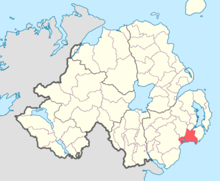
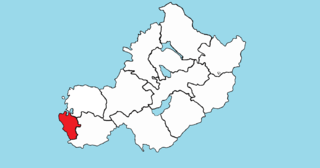
Lecale Upper is a barony in County Down, Northern Ireland. To its south lies the Irish Sea, and it is bordered by three other baronies; Lecale Lower and Kinelarty to the north; and Iveagh Upper, Lower Half to the west.
Magheracross is a townland and civil parish in County Fermanagh, Northern Ireland. It extends in area from just north of Enniskillen to the border with County Tyrone. There is also a small enclave in County Tyrone.
Brawny is a barony in south–west County Westmeath, Ireland. It was formed by 1672. It is bordered by County Roscommon to the west. It also borders two other Westmeath baronies: Kilkenny West and Clonlonan. The largest centre of population in the barony is the town of Athlone.