
Llandeilo is a town and community in Carmarthenshire, Wales, situated at the crossing of the River Towy by the A483 on a 19th-century stone bridge. Its population was 1,795 at the 2011 Census. It is adjacent to the westernmost point of the Brecon Beacons National Park.

The Preseli Hills or, as they are known locally and historically, Preseli Mountains is a range of hills in north Pembrokeshire, west Wales, mostly within the Pembrokeshire Coast National Park.

Nevern is both a parish and a community in Pembrokeshire, Wales. The community includes the settlements of Felindre Farchog, Monington, Moylgrove and Bayvil. The small village lies in the Nevern valley near the Preseli Hills of the Pembrokeshire Coast National Park 2 miles (3 km) east of Newport on the B4582 road.

South Pembrokeshire was one of six local government districts of Dyfed, Wales from 1974 to 1996.

Mynachlog-ddu is a village, parish and community in the Preseli Hills, Pembrokeshire, Wales. The community includes the parish of Llangolman.
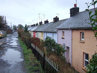
Rosebush is a small village in the community of Maenclochog, Pembrokeshire, southwest Wales, UK. It lies in the southern slopes of the Preseli Hills, about 1 mile (1.6 km) north west of the village of Maenclochog. Slate was extensively quarried nearby, and was exported by the Narberth Road and Maenclochog Railway, which was later extended towards Fishguard. Today, Rosebush is a centre for exploring the Preseli Hills.

Walton East is a small rural village and parish established around a church at least as early as Norman times. It is 2 miles (3.2 km) southwest of Llys y Fran and 1+1⁄2 miles (2.4 km) north of Clarbeston Road and in Wiston community in Pembrokeshire, Wales.

Llangolman is a village and parish in the southeastern Preseli Hills in Pembrokeshire, Wales. It is part of the community of Mynachlog-ddu. There are prehistoric remains nearby and the parish has a history of slate and clay quarrying.
Canaston Bridge is the location in Pembrokeshire, southwest Wales where the A40 trunk road crosses the Eastern Cleddau. It is on the edge of the Pembrokeshire Coast National Park, 14 miles (23 km) northeast of Pembroke, and close to Oakwood Theme Park and Blue Lagoon waterpark. It is about half a mile upstream of Blackpool Mill, at the normal tidal limit of the river.
Hasguard is a parish northwest of the town of Milford Haven in Pembrokeshire, Wales. The name applies to several other locations: Upper and Middle Hasguard, Hasguard Hall, Little Hasguard and Hasguard Cross, this last on the B4327 Haverfordwest to Dale road, and is a recorded historic place name by the Royal Commission.
Maenclochog is a village, parish and community in Pembrokeshire, south-west Wales. It is also the name of an electoral ward comprising a wider area of four surrounding communities. Maenclochog Community includes the small settlement of Llanycefn and the village of Rosebush.
Woodstock is a rural village in the southern foothills of the Preseli Hills in the community and parish of Ambleston, Pembrokeshire, Wales. There is a built-up area on the B4329 former turnpike, and another down a side-road, close to, but with no road access to Llys y Fran reservoir.
Llandeloy is a small village and parish in Pembrokeshire, South West Wales. Together with the parishes of Brawdy and Llanreithan, it constitutes the community of Brawdy, which had a census population of 611 in 2001.

Rudbaxton is a village, parish and a local government community in the county of Pembrokeshire, Wales. It is 81 miles (130 km) from Cardiff and 208 miles (335 km) from London.

Scleddau is a village and a community in the county of Pembrokeshire, Wales, and is 2 miles (3.2 km) south of Fishguard on the main A40 road. The Western Cleddau river which lends its name to the village flows under the main road. There are several springs in the village.

The B4329 is a scenic route and a former turnpike in Pembrokeshire, West Wales. It links Eglwyswrw in the north of the county to Haverfordwest, the county town in the south, in an approximately southwesterly direction, crossing the Preseli Mountains.

Haroldston St Issells is a former parish in Pembrokeshire, Wales, on the upper reaches of the Western Cleddau, 1 mile (1.6 km) southeast of Haverfordwest. Its area is 1,104 acres (447 ha); Haroldston church is co-located with Lower Haroldston and is a small attractive building. Haroldston ruins and Lower Haroldston can both be viewed from a circular walk along the banks of the Cleddau. Haroldston and other places in the parish are preserved as historic place names by the Royal Commission.

Monington is a small settlement and parish in the community of Nevern, north Pembrokeshire, Wales. It is on the Nant Ceibwr that flows through Moylegrove and into Ceibwr Bay. Part of the parish lies within the Pembrokeshire Coast National Park.
Tufton is a crossroads hamlet in the parish of Henry's Moat in Pembrokeshire, Wales, on the B4329, a road between Eglwyswrw and Haverfordwest across the Preseli Hills. It is in the community of Puncheston.
Llanychaer is a small rural village and parish in the community of Cwm Gwaun, north Pembrokeshire, Wales. It is 2 miles (3.2 km) southeast of the port of Fishguard.

