
Llansantffraed (Llansantffraed-juxta-Usk) is a parish in the community of Talybont-on-Usk in Powys, Wales, near Brecon. The benefice of Llansantffraed with Llanrhystud and Llanddeiniol falls within the Diocese of St Davids in the Church in Wales.

Llanelli is a market town and community in Carmarthenshire and the preserved county of Dyfed, Wales. It is located on the Loughor estuary and is the largest town in the county of Carmarthenshire. The town is 11 miles (18 km) north-west of Swansea and 12 miles (19 km) south-east of Carmarthen. The town had a population of 25,168 in 2011, estimated in 2019 at 26,225. The local authority was Llanelli Borough Council when the county of Dyfed existed, but it has been under Carmarthenshire County Council since 1996.

Llanfairfechan is a town and community in the Conwy County Borough, Wales. It is known as a seaside resort and had a population at the 2001 Census of 3,755, reducing to 3,637 at the 2011 Census. The history of the area dates back to at least Roman times, as demonstrated by the discovery of a large second century milestone, which is now preserved in the British Museum.

Llanfynydd is a village, parish and community in Carmarthenshire, Wales. The community population at the 2011 census was 499. It lies some 10 miles north-east of the county town, Carmarthen. Bordering it are the communities of Llansawel, Talley, Manordeilo and Salem, Llangathen, Llanegwad and Llanfihangel Rhos-y-Corn, all in Carmarthenshire.

Tremadog is a village in the community of Porthmadog, in Gwynedd, north west Wales; about one mile (1.6 km) north of Porthmadog town-centre. It was a planned settlement, founded by William Madocks, who bought the land in 1798. The centre of Tremadog was complete by 1811 and remains substantially unaltered. Tremadog hosted an unofficial National Eisteddfod event in 1872.

Llangedwyn is a village in Montgomeryshire, Powys, Wales. The population of the community at the 2011 census was 402. The community includes the hamlet of Pen-y-bont Llanerch Emrys.
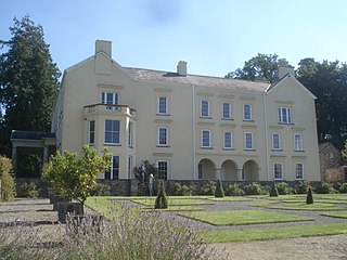
Aberglasney House and Gardens is a medieval house and gardens set in the Tywi valley in the parish of Llangathen, Carmarthenshire, West Wales. It is owned and run by Aberglasney Restoration Trust, a registered charity. The house is a Grade II* listed building and the gardens are listed, also at Grade II*, on the Cadw/ICOMOS Register of Parks and Gardens of Special Historic Interest in Wales.

Llangattock is a village, community and electoral ward in the Brecon Beacons National Park in Powys, Wales. It lies in the Usk Valley just across the river from the town of Crickhowell. The Monmouthshire and Brecon Canal passes through the village en route between Brecon and Pontypool. It is in the historic county of Breconshire.

Jeffreyston is a village, parish and community in Pembrokeshire.
Dinefwr Park National Nature Reserve is an 800 acres (320 ha) estate about a mile from the centre of Llandeilo in Carmarthenshire owned by the National Trust, with a mansion in the centre. The highest point is occupied by the ruined Dinefwr Castle, ancient castle of the Deheubarth kingdom. It is a grade I Historic Park and a Site of Special Scientific Interest.
Cathinog was a hundred, a geographic division, in the traditional county of Carmarthenshire, Wales. Its name derives from St. Cathen, a local saint to whom a church is dedicated in Llangathen.
Allt Penycoed Stream Section is a Site of Special Scientific Interest in Carmarthenshire, Wales. It is protected by law and has been designated as an SSSI since April 1985 in an attempt to protect rare or unique features or species within it. The site has an area of 1.62 hectares and is managed by Natural Resources Wales.

Allt y Gaer is a Site of Special Scientific Interest (SSSI) in Llangathen community, Carmarthenshire, Wales. It is a 3.5ha conifer woodland on the northern slopes of the Tywi Valley, which has SSSI protected designation because it holds the largest heronry in West Wales.
Allt y Wern is a Site of Special Scientific Interest (SSSI) in the community of Llangathen in Carmarthenshire, Wales. The site is a semi-natural broadleaved woodland with an area of 6 hectares.

Beacon Bog is a Site of Special Scientific Interest in the community of Llangynog in Carmarthenshire, Wales.
Wern Ddu Claypits is a Site of Special Scientific Interest near Van in Caerphilly County Borough, South Wales. The woodland is known locally as Coed y Werin, which surrounds a 19th-century clay pit, dug to supply clay to the Caerphilly Brick Company. It is designated because of the important coal measure rocks exposed there.

Llanegryn is a village and a community in Gwynedd, north-west Wales. It was formerly part of the historic county of Merionethshire. It is located within Snowdonia National Park south of the Snowdonia (Eryri) mountain range. Travelling by road, it is around 4 miles (6 km) north-east of Tywyn and 17 miles (27 km) south-west of Dolgellau. The nearest railway stations are at Tonfanau and Llwyngwril, both less than 3 miles (5 km) away.

In the United Kingdom, the term listed building refers to a building or other structure officially designated as being of special architectural, historical, or cultural significance; Grade I structures are those considered to be "buildings of exceptional interest". Listing was begun by a provision in the Town and Country Planning Act 1947. Once listed, strict limitations are imposed on the modifications allowed to a building's structure or fittings. In Wales, the authority for listing under the Planning Act 1990 rests with Cadw.
Carmarthenshire is a county in the south-west of Wales. It covers an area of 2,370 km2 (920 sq mi). In 2021 the population was approximately 188,200.

