Llanpumsaint

Last updated

Llanpumsaint
Gareg Hir - geograph.org.uk - 685328.jpg
Gareg Hir standing stone
Carmarthenshire UK location map.svg
Red pog.svg
Llanpumsaint
Location within Carmarthenshire
Population734 (20011) [1]
OS grid reference SN415295
Community
  • Llanpumsaint
Principal area
Preserved county
Country Wales
Sovereign state United Kingdom
Post town CARMARTHEN
Postcode district SA33
Dialling code 01267
Police Dyfed-Powys
Fire Mid and West Wales
Ambulance Welsh
UK Parliament
Senedd Cymru – Welsh Parliament
List of places
UK
Wales
Carmarthenshire
51°56′20″N4°18′04″W / 51.939°N 4.3011°W / 51.939; -4.3011

Llanpumsaint ( Loudspeaker.svg Welsh pronunciation ; Welsh "Llan" church + "pum" five + "saint" saint(s)) is a village and community in Carmarthenshire, Wales. In the 2001 UK Census, Llanpumsaint community had a population of 595. [1] It is not to be confused with Pumsaint, a small village some distance away on the River Cothi. The population increased in 2011 to 734, and thus the percentage of Welsh speakers declined. [2]

Contents

Llanpumsaint community comprises the neighbouring hamlet of Nebo, the spiritual community and temple at Skanda Vale and a number of farms.

According to the 2001 Census, 50% of those living in Llanpumsaint community are able to speak, read and write Welsh, [3] this is well above the 39% average recorded for Carmarthenshire in the same census. [4]

Location

Llanpumsaint is located on a minor road that joins the B4336 just north of Bronwydd Arms and the A486 at Llandysul and Pentrecwrt. The village straddles the River Gwili between Bronwydd and Llanllawddog, at the confluence of two small tributaries, Nant-cwm-cerwyn and Nant Aeron. The nearest major settlement is Carmarthen, approximately 4.5 miles (7 km) away by road.

The community is bordered by the communities of: Llanfihangel-ar-Arth; Llanllawddog; Bronwydd; and Cynwyl Elfed, all being in Carmarthenshire.

History

Foundation

The name Llanpumsaint translates as "Parish of the Five Saints" ("Llan" means church or enclosed area of land). The five saints were brothers named Gwyn, Gwynno, Gwynoro, Ceitho and Celynin who came from the nearby hamlet of Cynwyl Gaeo. They were sons of Cynyr Barbtruc (or "cut-beard"; Welsh: "Cynyr Farfdrwch") and descendants of Cunedda the Imperator (Welsh: "Cynyr Wledig").

The five brothers are said to have built the Llanpumsaint Parish Church around the 5th or 6th Century. It is thought that they built the church on a pre-existing pagan site. There are also five pools in Nant-cwm-cerwyn which are named after each of the saints. [5] These pools were the destination for pilgrimages to the village during the Middle Ages. Such pilgrimages tended to take place around the time of St. David's Day. [6]

The names of the five saints appear elsewhere in the area. One of the brothers, Ceitho, is the patron saint of Llangeitho in Ceredigion where he founded an abbey and lived as a hermit there within. Another example is St Celynin's Church in the neighbouring community of Bronwydd which was built as a missionary church to Llanpumsaint in 1894. [7]

Evidence of medieval settlement at Pant Glas

At Allt Pant Glas, to the south of Llanpumsaint village, there are earthworks indicating the site of a possible medieval timber castle of the motte and bailey or ringwork form. [8]

Railway village 1864-1965

In 1860 the Carmarthen and Cardigan Railway was opened. "Llanpumpsaint" station was opened in 1864 when the line was extended as far as Llandysul. At the height of its operation, the Carmarthen Aberystwyth Line linked Llanpumsaint to Carmarthen in the south (connecting to the West Wales Line) and to Cardigan, Aberaeron and Aberystwyth (connecting to the Cambrian Line) in the north.

The railway served the village for over 100 years until the line finally closed (having ceased carrying passengers in February 1965 and the station). Freight trains continued to pass through the village on their way between Felin Fach and Carmarthen until 1973 when the line was finally closed and lifted.

The dismantled railway still passes through the village and, until recently, the original "Llanpumpsaint" station sign could be seen in front of the Railway Inn. In neighbouring Bronwydd, a 1 mile long section of the line was reopened in 1978 for tourists and named the Gwili Railway. The Gwili Railway aims to eventually restore the railway as far as Llanpumsaint. Plans are currently underway to extend the line Southwards to the site of Abergwili Junction. [9] However, the logistics of restoring the track as far north as Llanpumsaint (there are around seven derelict bridges crossing the Gwili between Conwyl Elfed and Llanpumsaint [10] ) mean that there is currently no timetable for restoration.

Preceding station HR icon.svg   Heritage railways Following station
Terminus  Gwili Railway
Future Extension
  Conwyl
Proposed

Llanpumsaint Parish Church

Llanpumsaint Parish Church (The Church of St Celynin, Ceitho, Gwyn, Gwyno and Gwynoro) is a medieval church belonging to the Church in Wales. The precise age of the church is unknown. At the time of the Religious census of 1851, the parish priest William Henry Powell attested that the church had been "...consecrated from time immemorial." There is a 6th-century Ogham stone in the churchyard which may give some indication of the church's age. The original church building was restored in 1882. An extension to the nave and the porch date from 1933. [11] The east window of the nave was designed by Mildred "Elsi" Eldridge, the wife of renowned Welsh poet R. S. Thomas. [12]

Very near to Llanpumsaint Parish Church is Bethel Presbyterian Chapel which was originally built in 1796. Nearer to the old railway line there is also Caersalem Baptist Chapel which was built in 1904. [13]

Skanda Vale

Skanda Vale, also known as "The Community of the Many Names of God", is an interfaith temple/monastery located in the Llanpumsaint Community, at a distance of 1.6 miles (3 km) from Llanpumsaint village. The temple holds festivals which are attended by pilgrims from all over the UK and even further afield. Skanda Vale also runs a hospice and is a registered charity.

Valli the elephant was given to Skanda Vale as a gift from the Sri Lankan president in 1981.

Notable people

Related Research Articles

<span class="mw-page-title-main">Abergwili</span> Village and community in Carmarthenshire, Wales

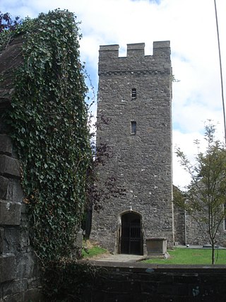
Abergwili is a village and community in Carmarthenshire, Wales, near the confluence of the rivers Towy and Gwili, close to the town of Carmarthen. It is also an electoral ward. Named after the village of Abergwili, the community includes the settlements of Peniel, Llanfihangel-uwch-Gwili and White Mill. The grounds of the former Bishop's Palace are listed on the Cadw/ICOMOS Register of Parks and Gardens of Special Historic Interest in Wales.

<span class="mw-page-title-main">Gwili Railway</span>

The Gwili Railway is a Welsh heritage railway, that operates a preserved standard gauge railway line from the site of Abergwili Junction in southwest Wales along a four-and-a-half-mile (7.2 km) section of the former Carmarthen to Aberystwyth line. The original railway closed in 1965, with the track being lifted in 1975.

<span class="mw-page-title-main">Carmarthen railway station</span> Railway station in Carmarthenshire, Wales

Carmarthen railway station is on is on the West Wales Line serving the town of Carmarthen, Wales, south of the River Towy. The station is operated by Transport for Wales. Great Western Railway also run a limited service between Carmarthen and London Paddington, usually six trains each way daily with an additional return service to Bristol Parkway.

Llanfihangel-ar-Arth is a village and community in the county of Carmarthenshire, Wales.

<span class="mw-page-title-main">Carmarthen–Aberystwyth line</span> Former railway line in Wales

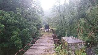
The Carmarthen–Aberystwyth line was originally a standard-gauge branch line of the Great Western Railway (GWR) in Wales, connecting Carmarthen and Aberystwyth.

<span class="mw-page-title-main">Carmarthen West and South Pembrokeshire (Senedd constituency)</span> Constituency of the Senedd

Carmarthen West and South Pembrokeshire is a constituency of the Senedd. It elects one Member of the Senedd by the first past the post method of election. In addition, it is one of eight constituencies in the Mid and West Wales electoral region, which elects four additional members, in addition to eight constituency members, to produce a degree of proportional representation for the region as a whole.

<span class="mw-page-title-main">Bronwydd</span> Village and community in Carmarthenshire, Wales

Bronwydd is a village and community in the county of Carmarthenshire, Wales, situated about three miles north of Carmarthen in the valley of the River Gwili. Bronwydd community comprises the village of Bronwydd Arms, a couple of nearby hamlets and a number of working farms in the surrounding area. In Census 2011, it had a population of 564.

<span class="mw-page-title-main">Cilycwm</span> Village and community in Carmarthenshire, Wales

Cilycwm is a village, parish and community located in Carmarthenshire, Wales. The community population taken at the 2011 census was 487.

<span class="mw-page-title-main">Cynwyl Elfed</span> Village and community in Carmarthenshire, Wales

Cynwyl Elfed is a village and community in the county of Carmarthenshire, Wales. The community includes the villages of Cynwyl Elfed, Blaenycoed and Cwmduad. It is situated about 5 miles (8.0 km) north of Carmarthen and had a population of 953 in 2001, increasing to 1,044 at the 2011 Census.

<span class="mw-page-title-main">Llangeler</span> Hamlet and community in Carmarthenshire, Wales

Llangeler is a hamlet and community located in north Carmarthenshire, Wales. The name is believed to refer to St. Gelert. Llangeler parish covers a wide area including to the west, the textile village of Drefach Felindre, Waungilwen, Cwmpengraig and to the east, Pont Tyweli which adjoins Llandysul on the Carmarthenshire side of the River Teifi. The population of the parish was 3,222 at the Census of 2001, increasing to 3,427 at the 2011 census.

Llanllawddog is a community located in Carmarthenshire, south-west Wales. The population of the community taken at the 2011 census was 703.

Newchurch and Merthyr is a community located in Carmarthenshire, Wales including the villages of Newchurch and Merthyr. The community population at the 2011 census was 676.

Llan and its variants are a common element of Celtic placenames in the British Isles and Brittany, especially of Welsh toponymy. In Welsh the name of a local saint or a geomorphological description follows the Llan morpheme to form a single word: for example Llanfair is the parish or settlement around the church of St. Mair. Goidelic toponyms end in -lann.

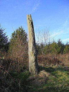
Ceitho was an abbot and a saint living in West Wales in the 6th century. According to legend he was one of the five sons born to Cynyr Barbtruc of Cynwyl Gaeo, and a descendant of the ancient Welsh king Cunedda Wledig. Along with his brothers Gwynno, Gwynoro, Celynin, and Gwyn, he became a saint. The five brothers are said to have founded the village Llanpumsaint.

Martha Llwyd, born Martha Williams, was a Welsh poet and Methodist hymnwriter. Due to health problems, Llwyd was unable to walk. She was carried aloft in her chair.

<span class="mw-page-title-main">River Gwili</span>

The River Gwili in Carmarthenshire, is a tributary of the River Towy, the longest river entirely in Wales. Its headwater is found east of Llanllawddog, in the Brechfa Forest. It runs west, through Llanpumsaint, to its confluence with the River Duad, just south of Cynwyl Elfed village. Here its course turns to the southeast, running through Bronwydd before joining the River Towy at Abergwili.

Llanpumpsaint was a railway station near the village of Llanpumpsaint, West Wales, serving the hamlet and the rural locale.

<span class="mw-page-title-main">Conwil railway station</span> Disused railway station in Wales

Conwil was a railway station near the village of Cynwyl Elfed in Carmarthenshire, Wales, serving the hamlet and the rural locale. It was once a thriving railway station, transporting both passenger traffic and locally produced goods, including wool, livestock, milk and timber.

The first election to the Carmarthen Rural District Council in Carmarthenshire, Wales was held in December 1894. It was followed by the 1898 election. The successful candidates were also elected to the Carmarthen Board of Guardians. In rural parishes, many councillors were returned unopposed.

References

  1. 1 2 "Carmarthenshire County Council - Llanpumsaint Community Council". Archived from the original on 15 November 2004. Retrieved 15 November 2004. Llanpumsaint Community Council
  2. "Custom report - Nomis - Official Labour Market Statistics".
  3. http://www.carmarthenshire.gov.uk/index.asp?locID=4473&docID=-1%5B%5D Welsh Language Skills in Carmarthenshire Community Wards
  4. "Carmarthenshire County CouncilÃ'Â -Ã'Â Welsh Language Statistics". Archived from the original on 23 December 2007. Retrieved 18 July 2008. Welsh Language Statistics for Carmarthenshire
  5. Llanpumsaint Local History (in Welsh)
  6. Aneirin Talfan Davies, Crwydro Sir Gâr (Llyfrau'r Dryw Publishing House, 1955)
  7. "St Celynin's Church, Bronwydd — Parish Control". Archived from the original on 7 June 2011. Retrieved 15 July 2008. The Church in Wales: St. Celynin's church, Bronwydd
  8. National Monuments Record of Wales: Crug, Allt Pant Glas
  9. "Home". Archived from the original on 6 February 2010. Retrieved 29 September 2012. Rheilffordd Gwili
  10. http://users.aol.com/WalesRails/gwil.htm Wales Rails: Gwili Railway
  11. "List of Plans Available". Archived from the original on 8 August 2007. Retrieved 15 July 2008. Carmarthenshire Church plans records
  12. "St Celynin, Ceitho, Gwyn, Gwyno and Gwynoro — Parish Control". Archived from the original on 7 June 2011. Retrieved 15 July 2008. The Church in Wales: St Celynin, Ceitho, Gwyn, Gwyno and Gwynoro
  13. http://www.genuki.org.uk/big/wal/CMN/Llanpumsaint/index.html UK & Ireland Genealogy online: Llanpumsaint