
The River Tay is the longest river in Scotland and the seventh-longest in the United Kingdom. The Tay originates in western Scotland on the slopes of Ben Lui, then flows easterly across the Highlands, through Loch Dochart, Loch Iubhair and Loch Tay, then continues east through Strathtay, in the centre of Scotland, then southeasterly through Perth, where it becomes tidal, to its mouth at the Firth of Tay, south of Dundee. It is the largest river in the UK by measured discharge. Its catchment is approximately 2,000 square miles (5,200 km2), the Tweed's is 1,500 square miles (3,900 km2) and the Spey's is 1,097 square miles (2,840 km2).
Loch Awe is a large body of freshwater in Argyll and Bute, Scottish Highlands. It has also given its name to a village on its banks, variously known as Loch Awe, or Lochawe. There are islands within the loch such as Innis Chonnell and Inishail.

Loch Rannoch is a freshwater loch in Perth and Kinross, Scotland. It is over 15 kilometres (9.3 mi) long in a west–east direction with an average width of about 1.2 kilometres (0.75 mi), and is deepest at its eastern end, reaching a depth of 130 metres (440 ft). The River Tummel begins at its eastern end, where the small village of Kinloch Rannoch can be found, whilst the wild expanse of Rannoch Moor extends to the west of the loch. The area surrounding Loch Rannoch, along with Rannoch Moor itself, was formerly part of the native Caledonian Forest that stretched across much of Northern Scotland. Native forest is now largely absent from much of area, due partly to logging, and partly to the climate becoming wetter, and Loch Rannoch is now largely surrounded by commercial forestry and open hillsides, although a small area remains at the Black Wood of Rannoch on the southern shore of the loch.

Ben Lawers is the highest mountain in the southern part of the Scottish Highlands. It lies to the north of Loch Tay, and is the highest point of a long ridge that includes seven Munros. It is the highest peak in Perthshire, and is the tenth highest Munro in Scotland. Ben Lawers was long thought to be over 4,000 feet (1,219.2 m) in height; accurate measurement in the 1870s showed it to be some 17 feet (5.2 m) short of this figure.

Loch Garry,, is a freshwater Loch 25 km north of Fort William, Lochaber, Scotland. Loch Garry is 11 km long and 50 m deep. It is fed by waters from Loch Quoich 10 km upstream on the River Garry, and drains into Loch Oich in the Great Glen just 5 km downstream. Loch Garry is much photographed from the A87 for its romantic setting and also because a quirk of perspective makes it appear like a map of Scotland.
Loch Ericht is a freshwater loch on the border between Perth and Kinross and the Highlands Council areas of Scotland. It has a north-east to south-west orientation. The village of Dalwhinnie lies at the north east end of the loch. Loch Ericht is the tenth largest freshwater lake in Scotland and has a good reputation for its trout fishing and Ferox trout.
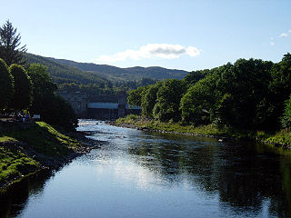
The River Tummel is a river in Perth and Kinross, Scotland. Water from the Tummel is used in the Tummel hydro-electric power scheme, operated by SSE.

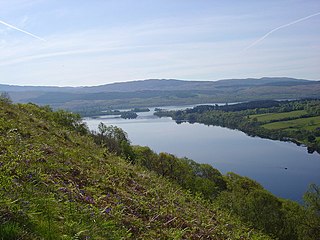
Loch Tummel is a long, narrow loch, 7 kilometres north west of Pitlochry in the council area of Perth and Kinross, Scotland. It is fed and drained by the River Tummel, which flows into the River Tay about 13 km south-east of the Clunie Dam at the loch's eastern end.
Glen Lyon is a glen in the Perth and Kinross region of Scotland. It is the longest enclosed glen in Scotland and runs for 34 miles from Loch Lyon in the west to the village of Fortingall in the east. This glen was also known as "An Crom Ghleann",. The land given over to the MacGregors was Scottish Gaelic: An Tòiseachd. It forms part of the Loch Rannoch and Glen Lyon National Scenic Area, one of 40 such areas in Scotland, which are defined so as to identify areas of exceptional scenery and to ensure its protection from inappropriate development by restricting certain forms of development. Sir Walter Scott described Glen Lyon as the longest, loneliest and loveliest glen in Scotland.

Loch Laggan is a freshwater loch situated approximately 6.5 mi (10.5 km) to the west of Dalwhinnie in the Scottish Highlands. The loch has an irregular shape, runs nearly northeast to southwest and is approximately 7 mi (11 km) in length. It has an average depth of 68 ft (21 m) and is 174 ft (53 m) at its deepest. The eastern end of the loch features the largest freshwater beach in Britain. Since 1934 Loch Laggan has been a reservoir, retained behind the Laggan Dam, forming part of the Lochaber hydro-electric scheme. At the northeast end of the loch is the hamlet of Kinloch Laggan.
Glen Strathfarrar is a glen in the Highland region of Scotland, near Loch Ness. Glen Strathfarrar is named for the River Farrar, which runs through the glen, and which derives from the Pictish var, and was known to the Romans as Varrar. The full name is a curious 'Gaelicisation' of the Gaelic: as a strath is an elongated glen, a title of 'Glen Strath' is tautological, and it is therefore likely that an English-only speaker, ignorant of the meaning of 'Strath' when transcribing the map of the location, recorded that this was the 'Glen of Strathfarrar'.
The Affric / Beauly hydro-electric power scheme for the generation of hydro-electric power is located in the western Highlands of Scotland. It is based around Glen Strathfarrar, Glen Cannich and Glen Affric, and Strathglass further downstream.

Loch Ness is a large, deep, freshwater loch in the Scottish Highlands extending for approximately 37 kilometres southwest of Inverness. Its surface is 16 metres above sea level. Loch Ness is best known for alleged sightings of the cryptozoological Loch Ness Monster, also known affectionately as "Nessie". It is connected at the southern end by the River Oich and a section of the Caledonian Canal to Loch Oich. At the northern end there is the Bona Narrows which opens out into Loch Dochfour, which feeds the River Ness and a further section of canal to Inverness, ultimately leading to the North Sea via the Moray Firth. It is one of a series of interconnected, murky bodies of water in Scotland; its water visibility is exceptionally low due to a high peat content in the surrounding soil.

Loch Loch is a remote freshwater loch, located in Glen Loch in Perth and Kinross, some 9.5 miles north of Pitlochry, Scotland and is within the Forest of Atholl.
The Loch Rannoch and Glen Lyon National Scenic Area is a national scenic area (NSA) covering the area surrounding Loch Rannoch, Glen Lyon, and the Ben Lawers ranges of mountains in Scotland. It is one of 40 such areas in Scotland, which are defined so as to identify areas of exceptional scenery and to ensure its protection from inappropriate development by restricting certain forms of development. The Loch Rannoch and Glen Lyon NSA covers 48,625 ha, most of which lies in the council area of Perth and Kinross, with a small portion lying in Stirling.

Loch Eigheach is a large upland dammed freshwater loch in the Scottish Highlands. It is located in Rannoch Moor in the Council Area of Perth and Kinross. The undisturbed Loch Eigheach was much smaller.

Loch Iubhair pronounced yoo-ar meaning yew loch, is a freshwater loch, located in Glen Dochart, and 4 miles east of the village of Crianlarich. Loch Dochart is located immediately to the south east, and the outflow of Loch Dochart, as the River Dochart flows into Loch Iubhair.


