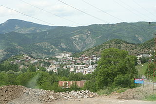
Lohan Cevizli village, 30 kilometers southwest of Turkey's 6th largest city, Gaziantep, is one of the largest and most developed villages in the south-east region of Turkey. It is also the oldest known continually inhabited village in the world with habitation stretching back to the stone age, over nine thousand years ago. Most of its residents are descendants of members of ancient Turkmen clans. Geographically, the village sits on the slope of a small hill, opposite a much larger hill with a spring water stream passing between the two hills. In times past the region was heavily wooded and green. Now, most of the greenery that survives, clings to the banks of the spring water stream running between the two hills. The province of Gaziantep, where Lohan Cevizli is located, is very near to the north west Syrian border. (Please find more information on the history of this region under Gaziantep).
The village has two names. "Lohan" - which is thought to be a derivative of a Turkish word, "Uluhan" which means "Large Caravansary”, and "Cevizli" - which is also a Turkish word meaning "has nuts", named after the village's walnut and pistachio trees.
The native fauna once included leopards, bears and tigers. All that remains are striped hyenas, spur-heeled tortoises, the occasional wolf, various species of skink lizards and chameleons, semi-domesticated dogs and cats, as well as geese and poultry. Along with farming animals such as sheep, goats, cattle, mules, donkeys and horses. Some other native species exist, although a new fauna census needs to be conducted in the region to determine what exactly remains.
Summers are dry and hot, swept by hot Saharan and Arabian desert winds. Snow falls in the winter for an average of 17 days during the coldest months. The weather is considered Mediterranean.
Brackish water is water having more salinity than freshwater, but not as much as seawater. It may result from mixing seawater with fresh water together, as in estuaries, or it may occur in brackish fossil aquifers. The word comes from the Middle Dutch root "brak". Certain human activities can produce brackish water, in particular civil engineering projects such as dikes and the flooding of coastal marshland to produce brackish water pools for freshwater prawn farming. Brackish water is also the primary waste product of the salinity gradient power process. Because brackish water is hostile to the growth of most terrestrial plant species, without appropriate management it is damaging to the environment.
Turkey is situated in Western Asia (97%) and the Balkans (3%), bordering the Black Sea, between Bulgaria and Georgia, and bordering the Aegean Sea and the Mediterranean Sea, between Greece and Syria. The geographic coordinates of the country lie at: 39°00′N35°00′E
Turkish cuisine is largely the heritage of Ottoman cuisine, which can be described as a fusion and refinement of Central Asian, Middle Eastern, Eastern European, Armenian and Balkan cuisines. Turkish cuisine has in turn influenced those and other neighbouring cuisines, including those of Southeast Europe (Balkans), Central Europe, and Western Europe. The Ottomans fused various culinary traditions of their realm with influences from Levantine cuisines, along with traditional Turkic elements from Central Asia, creating a vast array of specialities.
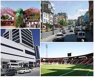
Gaziantep, previously and still informally called Antep, is the capital of Gaziantep Province, in the western part of Turkey's Southeastern Anatolia Region, some 185 kilometres (115 mi) east of Adana and 97 kilometres (60 mi) north of Aleppo, Syria. It is probably located on the site of ancient Antiochia ad Taurum, and is near ancient Zeugma.
The Neretva, also known as the Narenta, is one of the largest rivers of the eastern part of the Adriatic basin. Four HE power-plants with large dams provide flood protection, power and water storage. It is recognized for its natural environment and diversity of its landscape.
Kilis Province is a province in southern Turkey, on the border with Syria. It used to be the southern part of the province of Gaziantep and was formed in 1994. The town of Kilis is home to around 67% of the inhabitants of the province; the other towns and villages are very small.
Kemer is a seaside resort and district of Antalya Province on the Mediterranean coast of Turkey, 40 km (25 mi) west of the city of Antalya, on the Turkish Riviera.
Yankari National Park is a large wildlife park located in the south-central part of Bauchi State, in northeastern Nigeria. It covers an area of about 2,244 square kilometres (866 sq mi) and is home to several natural warm water springs, as well as a wide variety of flora and fauna. Its location in the heartland of the West African savanna makes it a unique way for tourists and holidaymakers to watch wildlife in its natural habitat. Yankari was originally created as a game reserve in 1956, but later designated Nigeria’s biggest national park in 1991. It is the most popular destination for tourists in Nigeria and, as such, plays a crucial role in the development and promotion of tourism and ecotourism in Nigeria. It is also one of the most popular eco-destinations in West Africa.
Şavşat is a town and district of Artvin Province in the Black Sea region, between the cities of Artvin and Kars on the border with Georgia at the far eastern end of Turkey.
Çukurova, alternatively known as Cilicia, is a geo-cultural region in south-central Turkey, covering the provinces of Mersin, Adana, Osmaniye and Hatay. With a population of almost 6 million, it is one of the largest population concentrations in Turkey.
Fossil Creek is a perennial stream accessed by forest roads near the community of Camp Verde in the U.S. state of Arizona. Primary access is from Forest Road 708 off Arizona State Route 260 east of Camp Verde. A tributary of the Verde River, Fossil Creek flows from its headwaters on the Mogollon Rim to meet the larger stream near the former Childs Power Plant.
Gelevara Deresi is one of two main streams of Espiye, a district of Giresun province in the eastern Black Sea region of Turkey. Its two main tributaries arise in the highlands of Espiye district of Giresun and Torul district of Gümüşhane.
Valle de Abdalajís is a town and municipality in the province of Málaga, part of the autonomous community of Andalucía in southern Spain. It is located in the comarca of Antequera. The municipality is situated approximately 50 kilometres from the provincial capital of Málaga. It has a population of approximately 3,000 residents. The natives are called Vallesteros.
Shocklach is a village in the civil parish of Shocklach Oviatt and District, in the Cheshire West and Chester district, in the county of Cheshire, England. Shocklach village is in the southwestern corner of Cheshire, approximately 1 kilometre (0.6 mi) from the border between Wales and England, the River Dee. The village lies between Wrexham, 10 kilometres (6 mi) to the west, and Nantwich, 21 kilometres (13 mi) to the east.
The Munzur Valley National Park, established on December 21, 1971, is the largest and the most biodiverse national park in Turkey. It is located at the Munzur Valley of Munzur Mountain Range within Tunceli Province in eastern Anatolia.
The Eckbach is a small river in the northeastern Palatinate and the southeastern Rhenish Hesse. It is slightly over 39 kilometres (24 mi) long.
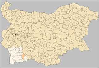
Garmen Municipality is situated in the southeastern part of Blagoevgrad Province in Southwestern Bulgaria. It is a rural municipality, composed of 16 villages. The administrative center is the village of Garmen, but the most populated village is Ribnovo. The municipality lies in the western part of the Rhodope mountains.
The Račna Karst Field is a karst field in the northern edge of the Lower Carniolan karst area, south of Grosuplje, Slovenia. It has rich natural and cultural value. Because of its ecological significance, it is anticipated that a nature park will be established there and that it will be included in the Natura 2000 program.
Soğuksu National Park, established on February 19, 1959, is a national park in central Anatolia, Turkey. It is located in the Kızılcahamam district of Ankara Province.
The wildlife of Kuwait consists of the flora and fauna of Kuwait and their natural habitats. Kuwait is a small country in the Middle East at the head of the Persian Gulf, located between Iraq and Saudi Arabia, and the land surface consists mainly of desert.
This page is based on this Wikipedia article Text is available under the CC BY-SA 4.0 license; additional terms may apply. Images, videos and audio are available under their respective licenses.