See also
| This disambiguation page lists articles associated with the title Long Trail. If an internal link led you here, you may wish to change the link to point directly to the intended article. |
The Long Trail is a hiking trail in Vermont.
Long Trail can also refer to:
| This disambiguation page lists articles associated with the title Long Trail. If an internal link led you here, you may wish to change the link to point directly to the intended article. |

Hanover is a town along the Connecticut River in Grafton County, New Hampshire, United States. The population was 11,260 at the 2010 census. Dartmouth College and the US Army Corps of Engineers Cold Regions Research and Engineering Laboratory are located in Hanover. The Appalachian Trail crosses the town.

Norwich is a town in Windsor County, in the U.S. state of Vermont. The population was 3,414 at the 2010 census. Home to some of the state of Vermont's wealthiest residents, the municipality is a commuter town for nearby Hanover, New Hampshire across the Connecticut River. The town is part of the Dresden School District, the first interstate school district in the United States, signed into law by President John F. Kennedy.

Scouting in Vermont has a long history, from the 1907 to the present day, serving thousands of youth in programs that suit the environment in which they live.

Clarendon is a town in Rutland County, Vermont, United States. The population was 2,571 at the 2010 census. Clarendon spans U.S. Route 7 and is split by the highway, the Cold River and Mill River, Otter Creek, and the Green Mountains into the villages of Clarendon, West Clarendon, East Clarendon, Clarendon Springs, and North Clarendon
Jericho is a city, populated since ancient times, in the West Bank, Palestine.

Springfield is a town in Windsor County, Vermont, United States. The population was 9,373 at the 2010 census.

The North Country National Scenic Trail, generally known as the North Country Trail or simply the N.C.T., is a footpath stretching over 4,600 miles (7,400 km) from [Middlebury, Vermont] in central [Vermont] to Lake Sakakawea State Park in central North Dakota in the United States; connecting both the Long Trail with the Lewis and Clark Trail. Passing through the eight states of Vermont, New York, Pennsylvania, Ohio, Michigan, Wisconsin, Minnesota and North Dakota, it is the longest of the eleven National Scenic Trails authorized by Congress. As of early 2019, 3,129 miles of the trail is in place.

The Long Trail is a hiking trail located in Vermont, running the length of the state. It is the oldest long-distance trail in the United States, constructed between 1910 and 1930 by the Green Mountain Club. The club remains the primary organization responsible for the trail, and is recognized by the state legislature as "the founder, sponsor, defender, and protector" of the Long Trail System.
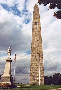
Bennington is a town in Bennington County, Vermont, in the United States. It is one of two shire towns of the county, the other being Manchester. The population is 15,764, as of the 2010 US Census. Bennington is the most populous town in southern Vermont, the third-largest town in Vermont and the sixth-largest municipality in the state including the cities of Burlington, Rutland, and South Burlington in the count.

The Green Mountains are a mountain range in the U.S. state of Vermont. The range runs primarily south to north and extends approximately 250 miles (400 km) from the border with Massachusetts to the border with Quebec, Canada. The part of the same range that is in Massachusetts and Connecticut is known as The Berkshires or the Berkshire Hills and the Quebec portion is called the Sutton Mountains, or Monts Sutton in French.

Vermont South is a suburb of Melbourne, Victoria, Australia, 20 km east of Melbourne's Central Business District. Its local government area is the City of Whitehorse. At the 2016 census, Vermont South had a population of 11,678.
The Green Mountain Club is a non-profit membership organization dedicated to preserving and protecting Vermont's Long Trail. The Long Trail is the oldest long-distance hiking trail in America and stretches from the Massachusetts state line to the Canada–United States border, along the main ridge of the Green Mountains.
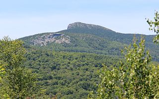
Camel's Hump is Vermont's third-highest mountain and, at 4085 feet, the highest undeveloped peak. Because of its distinctive profile, it is perhaps the state's most recognized mountain, featured on the state quarter. It is part of the Green Mountain range. With its neighbor to the north, Mount Mansfield, it borders the notch that the Winooski River has carved through the ridgeline of the Green Mountains over eons. The hiking trails on Camel's Hump were among the first cut in the Long Trail system, and Camel's Hump remains a popular summit for through- and day-hiking. The mountain is part of Camel's Hump State Park.

Mortimer Robinson Proctor, known as Mortimer R. Proctor, was an American politician from Vermont. He served as the 61st Lieutenant Governor of Vermont from 1941 to 1945, and as the 66th Governor of Vermont from 1945 to 1947.
The Long Trail School is an independent college-preparatory coeducational day school serving students 6-12 located in Dorset, Vermont, United States. Long Trail School was established on the founding principles that "every student is unique, small group instruction responds to individual needs, high academic standards motivate students, and financial need should not deter qualified students from applying." Long Trail School provides financial aid to qualified students. Many area students are eligible for some amount of tax-funded tuition assistance.

Bread Loaf Mountain is a mountain located in Addison County, Vermont, in the Breadloaf Wilderness in the Green Mountain National Forest. The mountain is part of the central Green Mountains. Bread Loaf Mountain is flanked to the northeast by Mount Wilson, part of Vermont's Presidential Range.
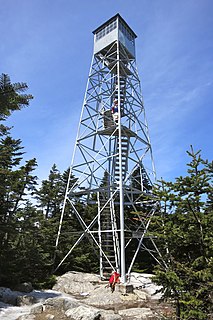
Stratton Mountain is a mountain located in Windham County, Vermont, in the Green Mountain National Forest. The mountain is the highest point of Windham County, and of the southern Green Mountains generally. A fire tower located on the summit is generally open for climbing by the public. There is also a small caretaker cabin at the summit that is inhabited in season by a caretaker from the Green Mountain Club.
Mount Carmel State Forest covers 263 acres (1.06 km2) in Chittenden, Vermont in Rutland County. Located in the Green Mountains, the forest's elevation ranges from 2380 to 3365 feet at the summit of Mount Carmel.
Long Trail State Forest protects 9,529 acres (38.56 km2) around a portion of the Long Trail, a 271 mi (436 km) hiking trail in Vermont. The forest runs through Belvidere, Eden, Lowell, Johnson, Montgomery, Waterville and Westfield in Franklin, Lamoille and Orleans counties. The forest is managed by the Vermont Department of Forests, Parks, and Recreation in partnership with the Green Mountain Club.
Jay State Forest covers 7,951 acres (32.18 km2) in two tracts in Jay, Richford, Montgomery and Westfield in Franklin and Orleans counties in Vermont. The forest is managed by the Vermont Department of Forests, Parks, and Recreation.