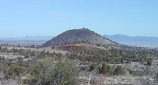
Schonchin Butte is a cinder cone on the northern flank of Medicine Lake Volcano in the Cascade Range in northern California. Frothy lava, cooled in the air, created the large cinder cones throughout Lava Beds National Monument. It is named for Old Schonchin, a chief of the Modoc people during the late nineteenth century. Erupting more than 30,000 years ago, the volcano spewed ash and cinders into the air much like a can of soda when shaken. A lava spatter rampart is at the very top.

Black Elk Peak is the highest natural point in South Dakota, United States. It lies in the Black Elk Wilderness area, in southern Pennington County, in the Black Hills National Forest. The peak lies 3.7 mi (6.0 km) west-southwest of Mount Rushmore. At 7,244 feet (2,208 m), it has been described by the Board on Geographical Names as the highest summit in the United States east of the Rocky Mountains. Though part of the North American Cordillera, it is generally considered to be geologically separate from the Rocky Mountains. Lost Mine peak in the Chisos Mountains of Texas, at an elevation of 7,535 feet, is the furthest east peak within the continental United States above 7,000 feet.

The Jamison Valley forms part of the Coxs River canyon system in the Blue Mountains of New South Wales, Australia. It is situated approximately 100 kilometres west of Sydney, capital of New South Wales, and a few kilometres south of Katoomba, the main town in the Blue Mountains.

Sioux Lookout is a town in Northwestern Ontario, Canada. Located approximately 350 km (220 mi) northwest of Thunder Bay, it has a population of 5,272 people, an elevation of 390 m, and its boundaries cover an area of 536 km², of which 157 is lake and wetlands. Known locally as the "Hub of the North", it is serviced by the Sioux Lookout Airport, Highway 72, and the Sioux Lookout railway station. According to a 2011 study commissioned by the municipality, health care and social services ranked as the largest sources of employment, followed by the retail trade, public administration, transportation and warehousing, manufacturing, accommodation and food services, and education.

Palomar Mountain is a mountain ridge in the Peninsular Ranges in northern San Diego County. It is famous as the location of the Palomar Observatory and Hale Telescope, and known for the Palomar Mountain State Park.

Cleveland National Forest encompasses 460,000 acres, mostly of chaparral, with a few riparian areas. A warm dry mediterranean climate prevails over the forest. It is the southernmost U.S. National Forest of California. It is administered by the U.S. Forest Service, a government agency within the United States Department of Agriculture. It is divided into the Descanso, Palomar and Trabuco Ranger Districts and is located in the counties of San Diego, Riverside, and Orange.
Mittagong is a town located in the Southern Highlands of New South Wales, Australia, in Wingecarribee Shire. The town acts as the gateway to the Southern Highlands when coming from Sydney. Mittagong is situated at an elevation of 635 metres (2,083 ft). The town is close to Bowral, Berrima, Moss Vale and the Northern Villages such as Yerrinbool and Colo Vale. Moreover, Mittagong is home to many wineries of the Southern Highlands which has been a recent growing wine and cellar door region.
Cornwall Hills Provincial Park is a provincial park in British Columbia, Canada, immediately west of Cache Creek, protecting part of the Cornwall Hills including their highest summit which features an old fire lookout.

Lake Munmorah or Munmorah Lake, a lagoon that is part of the Tuggerah Lakes, is located within the Central Coast Council local government area in the Central Coast region of New South Wales, Australia. The lake is located near the settlement of Lake Munmorah and is situated about 110 kilometres (68 mi) north of Sydney.

Saddleback Mountain is a mountain near Kiama in the Illawarra region of New South Wales, Australia. The mountain rises to about 600 metres (2,000 ft) above sea level on the Illawarra escarpment and has views of Noorinan Mountain, 662 metres (2,172 ft) above sea level, and Barren Grounds Plateau to the west and south to Coolangatta Mountain and Pigeon House Mountain to Ulladulla, and north over Lake Illawarra, the Illawarra escarpment and to the Cronulla Sandhills and Kurnell Oil Refinery on a clear day.

Poplar Hill First Nation is an Anishinaabe (Ojibway) First Nation band government, approximately 120 km north of Red Lake near the Ontario-Manitoba border. The First Nation is accessible by air and winter road. In May 2016, the First Nation had a registered population of 473 people.

Hudson is an unincorporated place and community in the municipality of Sioux Lookout, Kenora District in northwestern Ontario, Canada. It is located on Lost Lake on the English River in the Nelson River drainage basin.
Pavilion Mountain is a mountain in the Marble Range in the South Cariboo region of the South-Central Interior of British Columbia, Canada, located northeast of the ranching and First Nations community of Pavilion and to the north of Marble Canyon and immediately south of Kelly Lake, which is the focus of Downing Provincial Park. The term Pavilion Mountain is also used to refer to the historic ranch and associated rangeland on the "bench" on the mountain's southwestern side, and also to the road which traverses that benchland and the mountain's western shoulder and is the route of the Old Cariboo Road. The switchback descent from the summit of the road was known as the Rattlesnake Grade and was an infamous stretch of the old wagon road. From a junction at the road-summit, a road leads east along the spine of the mountain to the peak, which is the site of a microwave relay and former fire lookout. The mountain's only named subpeak, Mount Carson, at 2005 metres, is southeast of the fire lookout and is named for the original owner of the ranch and was briefly misapplied as the name of Pavilion Mountain. Robert Carson was one of the first settlers in the region and whose sons later became prominent MLAs and provincial cabinet ministers. The north wall of Marble Canyon is essentially the southeast buttress of Pavilion Mountain.

The Aermotor Windmill Company, or Aermotor Company, is an American manufacturer of wind-powered water pumps. The widespread use of their distinctive wind pumps on ranches throughout the arid plains and deserts of the United States has made their design a quintessential image of the American West.
Superior Junction is a community in the town of Sioux Lookout, Kenora District in northwestern Ontario, Canada. It is on the Marchington River downstream of Botsford Lake and upstream of the river's mouth at Abram Lake on the English River.
Pelican is an unincorporated settlement and railway point in the municipality of Sioux Lookout, Kenora District in northwestern Ontario, Canada. It is located just south of Pelican Lake on the English River, part of the Nelson River drainage basin.

Stoddard Hill State Park is a public recreation area located on the eastern shore of the Thames River, about five miles (8.0 km) south of Norwich, in the town of Ledyard, Connecticut. The state park covers 55 acres and offers facilities for boating, fishing, and hiking. It is managed by the Connecticut Department of Energy and Environmental Protection.

Bald Mountain, or Rondaxe Mountain, is a part of the Adirondack Mountains in the U.S. state of New York. The trail leading up the mountain is a popular hike, likely due to its proximity to tourist towns. The mountain is also home to the Rondaxe Mountain Fire Tower, which contributes to the trail's popularity.

Hager Mountain is a volcanic peak in Oregon in the northwest corner of the Basin and Range Province in the United States. The mountain is located south of the small unincorporated community of Silver Lake in south-central Oregon, and it is in the Fremont–Winema National Forest. On the summit, there is a fire lookout operated during the summer and fall by the United States Forest Service. There are several hiking trails that lead to the lookout station.
