
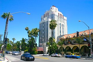
Hollywood is a neighborhood in the central region of Los Angeles, California. Its name has come to be a shorthand reference for the U.S. film industry and the people associated with it. Many of its studios such as Columbia Pictures, Disney, Paramount Pictures, Warner Bros., and Universal Pictures were founded there; Paramount still has its studios there.

Beverly Hills is a city in Los Angeles County, California. Located within 5.71 square miles (14.8 km2), and surrounded by the cities of Los Angeles and West Hollywood, it has a population of 32,701 according to the 2020 census.

Sunset Boulevard is a boulevard in the central and western part of Los Angeles, California, that stretches from the Pacific Coast Highway in Pacific Palisades east to Figueroa Street in Downtown Los Angeles. It is a major thoroughfare in the cities of Beverly Hills and West Hollywood, as well as several districts in Los Angeles.
The Sunset Strip is the 1.5-mile (2.4 km) stretch of Sunset Boulevard that passes through the city of West Hollywood, California. It extends from West Hollywood's eastern border with the city of Los Angeles near Marmont Lane to its western border with Beverly Hills at Phyllis Street. The Sunset Strip is known for its boutiques, restaurants, rock clubs, and nightclubs, as well as its array of huge, colorful billboards.

U.S. Bank Tower, known locally as the Library Tower and formerly as the First Interstate Bank World Center, is a 1,018-foot (310.3 m) skyscraper in downtown Los Angeles, California. It is, by structural height, the third-tallest building in California, the second-tallest building in Los Angeles, the eighteenth-tallest in the United States, the third-tallest west of the Mississippi River after the Salesforce Tower and the Wilshire Grand Center, and the 129th-tallest building in the world, after being surpassed by the Wilshire Grand Center. It is the only building in California whose roof height exceeds 1,000 feet (300 m). Because local building codes required all high-rise buildings to have a helipad, it was known as the tallest building in the world with a roof-top heliport from its completion in 1989 to 2010 when the China World Trade Center Tower III opened. It is also the third-tallest building in a major active seismic region; its structure was designed to resist an earthquake of 8.3 on the Richter scale. It consists of 73 stories above ground and two parking levels below ground. Construction began in 1987 with completion in 1989. The building was designed by Henry N. Cobb of the architectural firm Pei Cobb Freed & Partners and cost $350 million to build. It is one of the most recognizable buildings in Los Angeles, and often appears in establishing shots for the city in films and television programs.
Bel Air is a residential neighborhood on the Westside of Los Angeles, California, in the foothills of the Santa Monica Mountains. Founded in 1923, it is the home of The Hannah Carter Japanese Garden and the American Jewish University.
Griffith Park is a large municipal park at the eastern end of the Santa Monica Mountains, in the Los Feliz neighborhood of Los Angeles, California. The park covers 4,310 acres (1,740 ha) of land, making it one of the largest urban parks in North America. It is the second-largest city park in California, after Mission Trails Preserve in San Diego, and the 11th-largest municipally-owned park in the United States.
The culture of Los Angeles is rich with arts and ethnically diverse. The greater Los Angeles metro area has several notable art museums including the Los Angeles County Museum of Art (LACMA), the J. Paul Getty Museum on the Santa Monica Mountains overlooking the Pacific, the Museum of Contemporary Art (MOCA), and the Hammer Museum. In the 1920s and 1930s Will Durant and Ariel Durant, Arnold Schoenberg and other intellectuals were the representatives of culture, in addition to the movie writers and directors. As the city flourished financially in the middle of the 20th century, culture followed. Boosters such as Dorothy Buffum Chandler and other philanthropists raised funds for the establishment of art museums, music centers and theaters. Today, the Southland cultural scene is as complex, sophisticated and varied as any in the world.
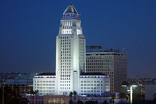
Los Angeles City Hall, completed in 1928, is the center of the government of the city of Los Angeles, California, and houses the mayor's office and the meeting chambers and offices of the Los Angeles City Council. It is located in the Civic Center district of downtown Los Angeles in the city block bounded by Main, Temple, First, and Spring streets, which was the heart of the city's central business district during the 1880s and 1890s. The Tom Bradley Tower located on the 27th floor is open to the public. Access to City Hall is located off of Main St. The rotunda is located on the 3rd floor accessible by all elevators. To access the Tom Bradley Tower requires the “Express Car Only” for floors 1, 3, and 10 through 22 elevators. Once on the 22nd floor transition to the Gold 22 thru 26 elevator bank. Finally once on the 26th floor, access to the 27th can be reached by stairs or one more elevator. Public restrooms are located on the 3rd and 26th floor.
Bunker Hill is a neighborhood in Los Angeles, California. It is part of Downtown Los Angeles.

Beverly Center is a shopping mall in Los Angeles, California, United States. It is an eight-story structure located at the edge of Beverly Hills and West Hollywood, between La Cienega and San Vicente boulevards. Anchor tenants include Bloomingdale's and Macy's, and a Macy's men's store. The mall's dramatic six-story series of escalators offer visitors views of the Hollywood Hills, Downtown Los Angeles, and Los Angeles Westside.

East Hollywood is a densely populated neighborhood of 78,000+ residents in the central region of Los Angeles, California. It is notable for being the site of Los Angeles City College, Barnsdall Park and a hospital district. There are seven public and five private schools, as well as a branch of the Los Angeles Public Library and three hospitals. Almost two-thirds of the people living there were born outside the United States and 90% were renters. In 2000 the neighborhood had high percentages of never-married people and of single parents.

Wilshire Boulevard is a prominent 15.83 mi (25.48 km) boulevard in the Los Angeles area of Southern California, extending from Ocean Avenue in the city of Santa Monica east to Grand Avenue in the Financial District of downtown Los Angeles. One of the principal east-west arterial roads of Los Angeles, it is also one of the major city streets through the city of Beverly Hills. Wilshire Boulevard runs roughly parallel with Santa Monica Boulevard from Santa Monica to the west boundary of Beverly Hills. From the east boundary it runs a block south of Sixth Street to its terminus.
Pico Boulevard is a major Los Angeles street that runs from the Pacific Ocean at Appian Way in Santa Monica to Central Avenue in Downtown Los Angeles, California, USA. It is named after Pío Pico, the last Mexican governor of Alta California.

The studio zone, also known as the thirty-mile zone (TMZ), is an area defined by a 30-mile (48 km) radius of "Hollywood" used by the American entertainment industry to determine employee benefits for filmwork done within it. Its center has traditionally been regarded as the southeast corner of Beverly Boulevard and La Cienega Boulevard in Los Angeles, California. The boundaries of the 30-mile radius includes almost all of the southern half of Los Angeles County, as well as parts of eastern Ventura County and northwestern Orange County.

The Hollywood Subway, as it is most commonly known, officially the Belmont Tunnel, was a subway tunnel used by the interurban streetcars of the Pacific Electric Railway. It ran from its northwest entrance in today's Westlake district to the Subway Terminal Building, in the Historic Core, the business and commercial center of the city from around the 1910s through the 1950s. The Subway Terminal was one of the Pacific Electric Railway’s two main hubs, the other being the Pacific Electric Building at 6th and Main. Numerous lines proceeded from the San Fernando Valley, Glendale, Santa Monica and Hollywood into the tunnel in Westlake and traveled southeast under Crown and Bunker Hill towards the Subway Terminal.

The Hollywood Line was a local streetcar line of the Pacific Electric Railway. It primarily operated between Downtown Los Angeles and Hollywood, with some trips as far away as Beverly Hills and West Los Angeles. It was the company's busiest route prior to the opening of the Hollywood Subway. Designated as route 32, the line operated from 1909 until 1953.