Okanogan County is a county located in the U.S. state of Washington along the Canada–US border. As of the 2010 census, the population was 41,120. The county seat is Okanogan, while the largest city is Omak. Its area is the largest in the state.

Omak is a city located in the foothills of the Okanogan Highlands in north-central Washington, United States. With an estimated 4,854 residents as of 2015, distributed over a land area of 3.43 square miles (8.9 km2), Omak is the largest municipality of Okanogan County and the largest municipality in Central Washington north of Wenatchee. The Greater Omak Area of around 8,229 inhabitants as of the 2010 census is the largest urban cluster in the Okanogan Country region, encompassing most of its twin city of Okanogan. The population has increased significantly since the 1910 census, reporting 520 residents just prior to incorporation in 1911.

The Okanogan National Forest is a U.S. National Forest located in Okanogan County in north-central Washington, United States.
The Henry M. Jackson Wilderness is a 103,297-acre (41,803 ha) designated wilderness area in the state of Washington, United States. The area lies adjacent to the southwest corner of the Glacier Peak Wilderness, northwest of Stevens Pass on U.S. Highway 2 and northeast of the town of Skykomish, Washington. Wild Sky Wilderness is located immediately southwest of the Henry M. Jackson Wilderness. While the wilderness straddles the Cascade Mountain Range, most of it is in the westside ecotype. The wilderness lies in parts of Snoqualmie, Mount Baker, and Wenatchee national forests.

The Colville National Forest is a U.S. National Forest located in northeastern Washington state. It is bordered on the west by the Okanogan National Forest and the Kaniksu National Forest to the east. The forest itself also contains Little Pend Oreille National Wildlife Refuge and the Lake Roosevelt National Recreation Area.

Wenatchee National Forest is a U.S. National Forest located in Washington. With an area of 1,735,394 acres, it extends about 137 miles along the eastern slopes of the Cascade Range of Washington, USA from Okanogan National Forest to Gifford Pinchot National Forest. The forest is located in Chelan, Kittitas and Yakima counties.

The Lake Chelan-Sawtooth Wilderness is a 153,057-acre (61,940 ha) protected wilderness area located within the Okanogan and Wenatchee national forests in Washington State. The wilderness borders Lake Chelan National Recreation Area and North Cascades National Park and the Stephen Mather Wilderness to the northwest. It was designated with the passage of the Washington Wilderness Act of 1984, on lands occupied by the old Chelan Division of the Washington Forest Reserve, now part of both the Okanogan and Wenatchee national forests.

Fort Okanogan was founded in 1811 on the confluence of the Okanogan and Columbia Rivers as a fur trade outpost. Originally built for John Jacob Astor’s Pacific Fur Company, it was the first American-owned settlement within Washington State, located in what is now Okanogan County. The North West Company, the PFC's primary competitor, purchased its assets and posts in 1813. In 1821 the North West Company was merged into Hudson's Bay Company, which took over operation of Fort Okanogan as part of its Columbia District. The fort was an important stop on the York Factory Express trade route to London via Hudson Bay.

The Withrow Moraine and Jameson Lake Drumlin Field is a National Park Service–designated privately owned National Natural Landmark located in Douglas County, Washington state, United States. Withrow Moraine is the only Ice Age terminal moraine on the Waterville Plateau section of the Columbia Plateau. The drumlin field includes excellent examples of glacially-formed elongated hills.

The Okanagan Range or Okanogan Range is a small subrange of the Cascade Range straddling the border between British Columbia and Washington south of the Similkameen River on the inland side of the range. The range is the northeasternmost extremity of the Cascade Range.
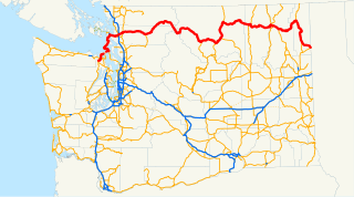
In the U.S. state of Washington, U.S. Route 97 is a 322-mile (518 km) route which traverses from the Oregon state line at the northern end of the Sam Hill Memorial Bridge in Maryhill, north to the Canada–US border in Okanogan County near Oroville. The highway serves major cities such as Goldendale, Yakima, Ellensburg and Wenatchee before continuing towards the Alaska Highway at the Yukon border as British Columbia Highway 97. Along the length of the roadway, US 97 is concurrent with State Route 14 in Maryhill, Interstate 82 (I-82) and US 12 between Union Gap and Ellensburg, I-90 briefly in Ellensburg, US 2 between Peshastin and rural Douglas County and SR 20 near Omak. An alternate route connects the highway with Chelan.

State Route 215 (SR 215) is a 6.24-mile long (10.04 km) state highway serving Okanogan County in the U.S. state of Washington. The highway travels northeast parallel to the Okanogan River from SR 20 in Okanogan to SR 155 Spur in Downtown Omak. SR 215 turns east to end at an intersection with SR 20 and U.S. Route 97 (US 97) in North Omak. The highway was previously part of State Road 10 and Primary State Highway 10 (PSH 10), concurrent with US 97, until a bypass of Omak was built in the 1960s. SR 20 was routed onto the highway after the 1964 highway renumbering, but was moved to the bypass and replaced by SR 215 in 1973.
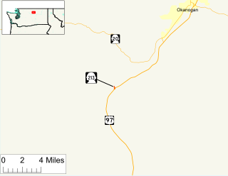
State Route 213 (SR 213) is the shortest state highway in the U.S. state of Washington. The 0.35-mile (0.56 km) long unsigned highway serves Malott, a community in Okanogan County. Extending from U.S. Route 97 (US 97) over the Okanogan River via a bridge to First Avenue in Malott, the roadway is semi-complete, as state law designates that the road should extend to SR 20 southwest of Okanogan. First appearing in a map in 1954, SR 213 originated as a branch of Primary State Highway 16 (PSH 16) in 1959 and later SR 20 Spur in 1964. SR 20 Spur became SR 213 in 1973 because another SR 20 Spur was recently established in Anacortes.
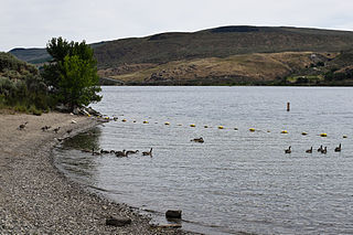
Bridgeport State Park is a public recreation area located two miles east of Bridgeport, Washington, on the north shore of Rufus Woods Lake, the Columbia River reservoir created by the Chief Joseph Dam. The state park was built through a partnership between Washington State Parks and the Army Corps of Engineers after completion of the dam in 1955. The park's 25-year lease was renewed in 1990 and again in 2015. The park covers 622 acres (252 ha) which include 7,500 feet (2,300 m) of shoreline, camping areas, four miles (6.4 km) of hiking trails, and facilities for boating, fishing, swimming, and golf.
Loop Loop was a small unincorporated community in Okanogan County, Washington, United States. According to the Geographic Names Information System, this is French for 'wolf wolf'. It was also known as Loup Loup.

The 2014 Washington wildfires were a series of 1,480 wildfires that burned 386,972 acres (1,566 km2) over the course of 2014. The first occurred primarily on the east side of the Cascade Range in Chelan and Okanogan counties. The fires burned private land, state land, and within the Okanogan and Wenatchee National Forests, ultimately covering over 350,000 acres. The first fire began on July 8 near the Entiat River. On July 14 a lightning storm started dozens more fires across the eastern Cascade Range. Governor Jay Inslee declared a state of emergency, activating the Washington National Guard. More lightning strikes later in the summer started additional fires.

Golden Horn is a granite mountain located in Okanogan County in Washington state. It is part of the Okanogan Range which is a sub-range of the North Cascades Range. Golden Horn is situated north of Methow Pass at headwaters of the Methow River on land administered by Okanogan National Forest. The nearest higher peak is Tower Mountain, 1.67 miles (2.69 km) to the southeast.