Tides are the rise and fall of sea levels caused by the combined effects of the gravitational forces exerted by the Moon and the Sun, and the rotation of the Earth.

A jetty is a structure that projects from the land out into water. Often, "jetty" refers to a walkway accessing the centre of an enclosed waterbody. The term is derived from the French word jetée, "thrown", and signifies something thrown out.

The littoral zone or nearshore is the part of a sea, lake, or river that is close to the shore. In coastal environments, the littoral zone extends from the high water mark, which is rarely inundated, to shoreline areas that are permanently submerged. The littoral zone always includes this intertidal zone, and the terms are often used interchangeably. However, the meaning of littoral zone can extend well beyond the intertidal zone.
Riparian water rights is a system for allocating water among those who possess land along its path. It has its origins in English common law. Riparian water rights exist in many jurisdictions with a common law heritage, such as Canada, Australia, and states in the eastern United States.
Slack water, also known as 'the stand of the tide', is a short period in a body of tidal water when the water is completely unstressed, and there is no movement either way in the tidal stream, and which occurs before the direction of the tidal stream reverses. Slack water can be estimated using a tidal atlas or the tidal diamond information on a nautical chart. The time of slack water, particularly in constricted waters, does not occur at high and low water, and in certain areas, such as Primera Angostura, the ebb may run for up to three hours after the water level has started to rise, and the flood may run for three hours after the water has started to fall. Thornton Lecky, writing in 1884, illustrates the phenomenon with an inland basin of infinite size, connected to the sea by a narrow mouth. Since the level of the basin is always at mean sea level, the flood in the mouth starts at half tide, and its velocity is at its greatest at the time of high water, with the strongest ebb occurring conversely at low water.

Pulau Hantu is located to the south of the main island of Singapore, off the Straits of Singapore. Pulau Hantu is actually made up of two islets: Pulau Hantu Besar and Pulau Hantu Kechil, with a total area of 12.6 hectares. At low tide, it is possible to wade across the shallow lagoon between the two islands, but not at high tide.
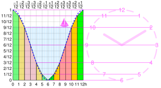
The rule of twelfths is an approximation to a sine curve. It can be used as a rule of thumb for estimating a changing quantity where both the quantity and the steps are easily divisible by 12. Typical uses are predicting the height of the tide or the change in day length over the seasons.

The intertidal zone, also known as the foreshore or seashore, is the area that is above water level at low tide and underwater at high tide. This area can include several types of habitats with various species of life, such as seastars, sea urchins, and many species of coral. Sometimes it is referred to as the littoral zone, although that can be defined as a wider region.

The public trust doctrine is the principle that the sovereign holds in trust for public use some resources such as shoreline between the high and low tide lines, regardless of private property ownership.
Tidal range is the height difference between high tide and low tide. Tides are the rise and fall of sea levels caused by gravitational forces exerted by the Moon and Sun and the rotation of Earth. Tidal range is not constant but changes depending on the locations of the Moon and Sun.

Great Bay is a tidal estuary located in Strafford and Rockingham counties in eastern New Hampshire, United States. The bay occupies over 6,000 acres (24 km2), not including its several tidal river tributaries. Its outlet is at Hilton Point in Dover, New Hampshire, where waters from the bay flow into the Piscataqua River, thence proceeding southeast to the Atlantic Ocean near Portsmouth. The northern end of the bay, near its outlet, is referred to as Little Bay.

Marine ecosystems are the largest of Earth's aquatic ecosystems and are distinguished by waters that have a high salt content. These systems contrast with freshwater ecosystems, which have a lower salt content. Marine waters cover more than 70% of the surface of the Earth and account for more than 97% of Earth's water supply and 90% of habitable space on Earth. Marine ecosystems include nearshore systems, such as the salt marshes, mudflats, seagrass meadows, mangroves, rocky intertidal systems and coral reefs. They also extend outwards from the coast to include offshore systems, such as the surface ocean, pelagic ocean waters, the deep sea, oceanic hydrothermal vents, and the sea floor. Marine ecosystems are characterized by the biological community of organisms that they are associated with and their physical environment.

Broughton Bay is a beach of the Gower Peninsula, south Wales, located at the north western tip. The bay is backed by sand dunes further inland. Access to the adjacent Whiteford Sands beach to the west is only available at low tide.
A baseline, as defined by the United Nations Convention on the Law of the Sea, is the line along the coast from which the seaward limits of a state's territorial sea and certain other maritime zones of jurisdiction are measured, such as a state's exclusive economic zone. Normally, a sea baseline follows the low-water line of a coastal state. When the coast is deeply indented, has fringing islands or is highly unstable, straight baselines may be used.
Paripueira is a municipality located in the Brazilian state of Alagoas. Its population is 8,762 (2005) and its area is 93 km².
"Boston" is a song by American rock band Augustana, from their debut album All the Stars and Boulevards (2005). It was originally produced in 2003 by Jon King for their demo, Midwest Skies and Sleepless Mondays, and was later re-recorded with producer Brendan O'Brien for All the Stars and Boulevards.

The Pamet River is a 4.2-mile-long (6.8 km) river in Truro, Massachusetts on Cape Cod. It is named for the Paomet tribe.

The term fish kill, known also as fish die-off, refers to a localized die-off of fish populations which may also be associated with more generalized mortality of aquatic life. The most common cause is reduced oxygen in the water, which in turn may be due to factors such as drought, algae bloom, overpopulation, or a sustained increase in water temperature. Infectious diseases and parasites can also lead to fish kill. Toxicity is a real but far less common cause of fish kill.

Menunketesuck Island, also known as Menunketesuck Point, is an island in Long Island Sound belonging to the town of Westbrook in Middlesex County, Connecticut.
Low-tide elevation is a naturally formed area of land which is above water and surrounded by water at low tide but submerged at high tide. It may be a mudflat or reef.