Carniola is a historical region that comprised parts of present-day Slovenia. Although as a whole it does not exist anymore, Slovenes living within the former borders of the region still tend to identify with its traditional parts Upper Carniola, Lower Carniola, and to a lesser degree with Inner Carniola. In 1991, 47% of the population of Slovenia lived within the borders of the former Duchy of Carniola.

Kočevje is a town and the seat of Municipality of Kočevje in southern Slovenia.

White Carniola is a traditional region in southeastern Slovenia on the border with Croatia. Due to its smallness, it is often considered a subunit of the broader Lower Carniola region, although with distinctive cultural, linguistic, and historical features.
The Duchy of Carniola was an imperial estate of the Holy Roman Empire, established under Habsburg rule on the territory of the former East Frankish March of Carniola in 1364. A hereditary land of the Habsburg monarchy, it became a constituent land of the Austrian Empire in 1804 and part of the Kingdom of Illyria until 1849. A separate crown land from 1849, it was incorporated into the Cisleithanian territories of Austria-Hungary from 1867 until the state's dissolution in 1918. Its capital was German: Laibach, today Ljubljana.
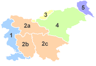
Upper Carniola is a traditional region of Slovenia, the northern mountainous part of the larger Carniola region. The largest town in the region is Kranj, and other urban centers include Jesenice, Tržič, Škofja Loka, Kamnik, and Domžale. It has around 300,000 inhabitants or 14% of the population of Slovenia.

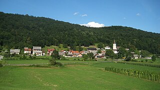
Metlika is a town in southeastern Slovenia. It is the seat of the Municipality of Metlika. It lies on the left bank of the Kolpa River on the border with Croatia. It is in the heart of the area of White Carniola, the southeastern part of the traditional region of Lower Carniola. It is now included in the Southeast Slovenia Statistical Region.
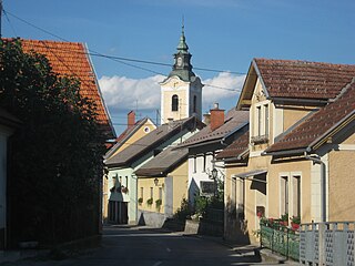
Semič is a settlement in southeastern Slovenia. It is the administrative seat of the Municipality of Semič.

Gottschee refers to a former German-speaking region in Carniola, a crownland of the Habsburg Empire, part of the historical and traditional region of Lower Carniola, now in Slovenia. The region has been a county, duchy, district, and municipality during various parts of its history. The term often also refers to the entire ethnolinguistic enclave regardless of administrative borders. Today Gottschee largely corresponds to the Municipality of Kočevje. The original German settlers of the region are called Gottschee Germans or Gottscheers, and their German dialect is called Gottschee German or Gottscheerish.
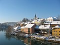
Gorenje Kamenje is a settlement in the hills north of the town of Novo Mesto in southeastern Slovenia. The entire City Municipality of Novo Mesto is part of the traditional region of Lower Carniola and is now included in the Southeast Slovenia Statistical Region.

Mirna is a nucleated village and a minor economic centre in central Lower Carniola, Slovenia. It is the largest settlement of the Mirna Valley and the seat of the Municipality of Mirna. It is situated at the crossing of regional roads and a confluence of several creeks with the Mirna River, along the railway line linking Sevnica and Trebnje.

Gotenica is a settlement in the Municipality of Kočevje in southern Slovenia. The area is part of the traditional region of Lower Carniola and is now included in the Southeast Slovenia Statistical Region.
Kočevske Poljane is a village in the Municipality of Dolenjske Toplice in Slovenia. The area is part of the historical region of Lower Carniola. The municipality is now included in the Southeast Slovenia Statistical Region. The village includes the hamlets of Gorica and Trnovec.

Stare Žage is a settlement in the Municipality of Dolenjske Toplice in Slovenia. The area is part of the historical region of Lower Carniola. The municipality is now included in the Southeast Slovenia Statistical Region.

Planina is a village in the Municipality of Semič in Slovenia. It lies on the southern slopes of Mount Mirna in the southern part of Kočevje Rog. It was inhabited by Gottschee Germans that were expelled in 1941 during the Second World War. The area is part of the historical region of Lower Carniola. The municipality is now included in the Southeast Slovenia Statistical Region.

Mixed Kočevje subdialects is a catch-all category for the Slovene dialects of heterogeneous origin now spoken in the Kočevje region, between Goteniška Gora in the west and the Kočevje Rog Plateau in the east, and spanning as far south as the border with Croatia border. The microdialects are very poorly studied, but they are very close to standard Slovene. The subdialects border the North White Carniolan dialect to the east, South White Carniolan dialect to the southwest, Kostel dialect to the south, Čabranka dialect to the west, and Lower Carniolan dialect to the north. The subdialects are derived from many different dialect bases, but they are currently listed as a special group of subdialects in the Lower Carnolan dialect group.
This article uses Logar transcription.
The North White Carniolan dialect is a Slovene dialect spoken in White Carniola north of Dobliče and Griblje. The dialect was partially influenced by immigrants of Serbo-Croatian origin that moved to this area in the 15th and 16th centuries. The dialect borders the Lower Carniolan dialect to the north, Mixed Kočevje subdialects to the west, and South White Carniolan dialect to the south, as well as Prigorje and Goran Kajkavian to the east and Eastern Herzegovinian Shtokavian to the northeast. The dialect belongs to the Lower Carniolan dialect group, and it evolved from Lower Carniolan dialect base.
The Eastern Lower Carniolan subdialect is a Slovene subdialect in the Lower Carniolan dialect group. It is spoken south of the Lower Sava Valley dialect in the watersheds of the Mirna and Temenica rivers, east of a line running from west of Trebnje and west of Novo Mesto to the lower Krka Valley. The dialect includes the settlements of Kostanjevica na Krki, Krmelj, Mirna, Mokronog, Novo Mesto, Raka, Šentjernej, Šentrupert, Škocjan and Trebnje.
This article uses Logar transcription.
Seč is a remote abandoned settlement in the City Municipality of Novo Mesto in southern Slovenia. The area is part of the traditional region of Lower Carniola and is now included in the Southeast Slovenia Statistical Region. Its territory is now part of the village of Travni Dol.