Interstate 196 (I-196) is an auxiliary Interstate Highway that runs for 80.6 miles (129.7 km) in the US state of Michigan. It is a state trunkline highway that links Benton Harbor, South Haven, Holland, and Grand Rapids together. In Kent, Ottawa, and Allegan counties, I-196 is known as the Gerald R. Ford Freeway, or simply the Ford Freeway, after the 38th President of the United States, Gerald Ford, who was raised in Grand Rapids and served Michigan in the House of Representatives. This name generally refers only to the section between Holland and Grand Rapids. I-196 changes direction; it is signed as a north–south highway from its southern terminus to the junction with US Highway 31 (US 31) just south of Holland, and as an east–west trunkline from this point to its eastern terminus at an interchange with I-96, its parent highway. There are currently three business routes related to the main freeway. There are two business loops and one business spur that serve South Haven, Holland and the Grand Rapids areas. Another business spur for Muskegon had been designated relative to the I-196 number.

M-99 is a north–south state trunkline highway in the Lower Peninsula of the US state of Michigan. It runs from the Ohio state border, where it connects to State Route 15 (SR 15), north to Lansing, where it terminates at a junction with Interstate 496 (I-496) and the Capitol Loop. The highway mainly serves local communities along the route as it passes through farm lands in the southern part of the state. One segment is routed concurrently with US Highway 12 (US 12) in Jonesville while the northern end runs through urban areas on a street named for Martin Luther King, Jr. in Lansing.

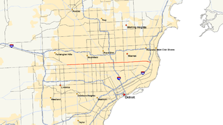
M-3 is a north–south state trunkline highway in the Detroit metropolitan area of the US state of Michigan. For most of its length, the trunkline is known as Gratiot Avenue. The trunkline starts in Downtown Detroit and runs through the city in a northeasterly direction along one of Detroit's five major avenues. The highway passes several historic landmarks and through a historic district. It also connects residential neighborhoods on the city's east side with suburbs in Macomb County and downtown.
M-28 is an east–west state trunkline highway that traverses nearly all of the Upper Peninsula of the U.S. state of Michigan, from Wakefield to near Sault Ste. Marie in Bruce Township. Along with US Highway 2 (US 2), M-28 forms a pair of primary highways linking the Upper Peninsula from end to end, providing a major access route for traffic from Michigan and Canada along the southern shore of Lake Superior. M-28 is the longest state trunkline in Michigan numbered with the "M-" prefix at 290.373 miles (467.310 km). The entire highway is listed on the National Highway System, while three sections of M-28 are part of the Lake Superior Circle Tour. M-28 also carries two memorial highway designations along its route.
US Highway 16 (US 16), also called Grand River Avenue for much of its length in the state, was one of the principal pre-Interstate roads in the state of Michigan. Before the creation of the United States Numbered Highway System in 1926, the highway had been designated M-16. The modern route of Grand River Avenue cuts across the Lower Peninsula in a northwest–southeast fashion from near Grand Rapids to Detroit. Before the late 1950s and early 1960s, US 16 followed other roads between Muskegon and Grand Rapids, and then Grand River Avenue through Lansing to Detroit. In the years immediately preceding the creation of the Interstate Highway System, US 16 was shifted from older roads to newer freeways. Later, it was co-designated as an Interstate. When the gap in the freeway was filled in around Lansing, the US 16 designation was decommissioned in the state. The freeway was then solely designated Interstate 96 (I-96) east of Grand Rapids and I-196 west of that city.

M-15 is a north–south state trunkline highway in the US state of Michigan. The southern terminus is a junction with US Highway 24 (US 24) just south of Clarkston on the northwestern edge of the Detroit metropolitan area. The trunkline is a recreational route running north and northwest to the Tri-Cities area. The northern terminus is the junction with M-25 on the east side of Bay City. The total length is about 73 2⁄3 miles (118.6 km) between the two regions.
M-102 is an east–west state trunkline highway in the US state of Michigan that runs along the northern boundary of Detroit following 8 Mile Road. The highway follows the Michigan Baseline, a part of the land survey of the state, and the roadway is also called Base Line Road in places. As a county road or city street, 8 Mile Road extends both east and west of the M-102 designation, which leaves 8 Mile on the eastern end to follow Vernier Road. The western terminus of M-102 is at the junction of 8 Mile Road and M-5 and the opposite end is at Vernier Road and Interstate 94 (I-94). The 8 Mile Road name extends west to Pontiac Trail near South Lyon with a discontinuous segment located west of US Highway 23 (US 23). The eastern end of 8 Mile Road is in Grosse Pointe Woods, near I-94, with a short, discontinuous segment east of Mack Avenue.
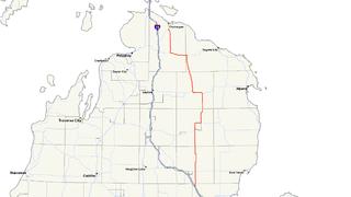
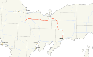
M-33 is a north–south state trunkline highway in the US state of Michigan that runs from Interstate 75 (I-75) at Alger in Arenac County north to M-27 near Cheboygan. In between, the trunkline runs through rural sections of the northeastern Lower Peninsula including state and national forest areas. M-33 connects to a handful of parks and crosses several of the rivers in that section of the state. It runs concurrently with three other state highways, sharing pavement to connect through several small communities of Northern Michigan.

M-20 is a state trunkline highway in the US state of Michigan that runs from New Era to Midland. It crosses through rural Lower Peninsula forest land between the two ends. The highway serves the college towns of Big Rapids and Mt. Pleasant, home of the main campuses of Ferris State University and Central Michigan University, both located near the trunkline.
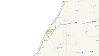
M-63 is a state trunkline highway in the US state of Michigan that runs from M-139 at Scottdale through the cities of Benton Harbor and St. Joseph to Interstate 196/US Highway 31 (I-196/US 31) at exit 7 just outside Hagar Shores. The trunkline runs through residential areas south of St. Joseph and through the central business districts of the twin cities. Further north, M-63 runs along the Lake Michigan shoreline.
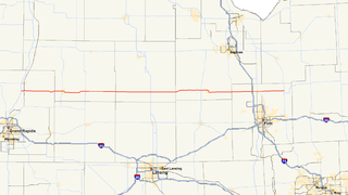
M-57 is an east–west state trunkline highway in the US state of Michigan. The 105.377-mile (169.588 km) highway connects US Highway 131 (US 131) near Rockford on the west end to M-15 near Otisville in the Lower Peninsula. In between, the mostly rural highway passes through farmland and connects several highways and smaller towns together. Three of these highways are freeways: US 131, US 127 and Interstate 75 (I-75). Along the way, between 3,700 and 22,300 vehicles use the highway daily.
M-94 is a state trunkline in the Upper Peninsula of the US state of Michigan. It runs for 86.983 miles (139.986 km) from K. I. Sawyer to Manistique. The highway is part of the Lake Superior Circle Tour during a concurrency with M-28. M-94 crosses the Siphon Bridge in Manistique, unique for the fact that the bridge roadway is below water level.

M-64 is a north–south state trunkline highway in the Upper Peninsula of the US state of Michigan. It runs for approximately 63 3⁄4 miles (102.6 km) through the western part of the state in land that is part of the Ottawa National Forest. The highway connects with County Trunk Highway B (CTH-B) at the state line near Presque Isle, Wisconsin. As it passes through dense forests, M-64 runs along lakes Gogebic and Superior. The northern end is at a junction with US Highway 45 (US 45) in Ontonagon.
M-114 was the designation of a former state trunkline highway and planned beltline in the US state of Michigan around the city of Grand Rapids. It was designated by the end of 1929 on various streets in adjoining cities and townships. By the 1940s, sections of it on the west and south sides of Grand Rapids were given new designations and the segment along the east side of town was finished. By late 1945 the highway designation was completely decommissioned in favor of other numbers. M-114 split into two branches, one running east–west and the other running north–south. The east–west spur routing is now local streets while the rest is part of state highways.
US Highway 12 (US 12) is an east–west US Highway that runs from Aberdeen, Washington, to Detroit, Michigan. In Michigan it runs for 210 miles (338 km) between New Buffalo and Detroit as a state trunkline highway and Pure Michigan Byway. On its western end, the highway is mostly a two-lane road that runs through the southern tier of counties roughly parallel to the Indiana state line. It forms part of the Niles Bypass, a four-lane expressway south of Niles in the southwestern part of the state, and it runs concurrently with the Interstate 94 (I-94) freeway around the south side of Ypsilanti in the southeastern. In between Coldwater and the Ann Arbor area, the highway angles northeasterly and passes the Michigan International Speedway. East of Ypsilanti, US 12 follows a divided highway routing on Michigan Avenue into Detroit, where it terminates at an intersection with Cass Avenue.
US Highway 23 (US 23) is a north–south United States Numbered Highway that runs from Jacksonville, Florida, to Mackinaw City, Michigan. In the US state of Michigan, it is a major, 362-mile-long (583 km), north–south state trunkline highway that runs through the Lower Peninsula. The trunkline is a freeway from the Michigan–Ohio state line near Lambertville to the city of Standish, and it follows the Lake Huron shoreline from there to its northern terminus. Serving the cities of Ann Arbor and Flint, US 23 acts as a freeway bypass of the Metro Detroit area. Overall, the highway runs through rural areas of the state dominated by farm fields or woodlands; some segments are urban in character in the Ann Arbor, Flint and Tri-Cities areas. The section from Flint north to Standish also carries Interstate 75 (I-75) along a concurrency that includes a segment that carries almost 70,000 vehicles on a daily basis.
Interstate 69 (I-69) is a part of the Interstate Highway System that will eventually run from the Mexican border in Texas to the Canadian border at Port Huron, Michigan. In Michigan, it is a state trunkline highway that enters the state south of Coldwater and passes the cities of Lansing and Flint in the Lower Peninsula. A north–south freeway from the Indiana–Michigan border to the Lansing area, it changes direction to east–west after running concurrently with I-96. The freeway continues to Port Huron before terminating in the middle of the twin-span Blue Water Bridge while running concurrently with I-94 at the border. There are four related business loops for I-69 in the state, connecting the freeway to adjacent cities.
US Highway 25 (US 25) was a part of the United States Numbered Highway System in the state of Michigan that ran from the Ohio state line near Toledo and ended at the tip of The Thumb in Port Austin. The general routing of this state trunkline highway took it northeasterly from the state line through Monroe and Detroit to Port Huron. Along this southern half, it followed undivided highways and ran concurrently along two freeways, Interstate 75 (I-75) and I-94. Near the foot of the Blue Water Bridge in Port Huron, US 25 turned north and northwesterly along the Lake Huron shoreline to Port Austin.
