Related Research Articles

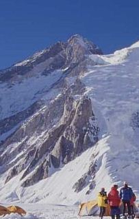
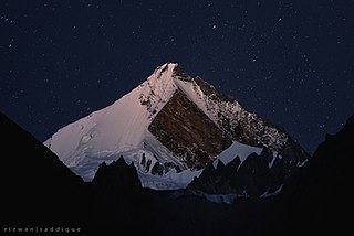
K2, at 8,611 metres (28,251 ft) above sea level, is the second-highest mountain on Earth, after Mount Everest at 8,849 metres (29,032 ft). It lies in the Karakoram range, partially in the Gilgit-Baltistan region of Pakistan-administered Kashmir and partially in the China-administered Trans-Karakoram Tract in the Taxkorgan Tajik Autonomous County of Xinjiang.

The Karakoram is a mountain range in the Kashmir region spanning the borders of Pakistan, China, and India, with the northwestern extremity of the range extending to Afghanistan and Tajikistan. Most of the Karakoram mountain range falls under the jurisdiction of Gilgit-Baltistan, which is administered by Pakistan. Its highest peak, K2, is located in Gilgit-Baltistan. It begins in the Wakhan Corridor (Afghanistan) in the west, encompasses the majority of Gilgit-Baltistan, and extends into Ladakh and Aksai Chin.

Gasherbrum I, surveyed as K5 and also known as Hidden Peak, is the 11th highest mountain in the world at 8,080 metres (26,510 ft) above sea level. It is located between Shigar District in the Gilgit–Baltistan region of Pakistan and Tashkurgan in the Xinjiang of China. Gasherbrum I is part of the Gasherbrum Massif, located in the Karakoram region of the Himalaya. Gasherbrum is often claimed to mean "Shining Wall", presumably a reference to the highly visible face of the neighboring peak Gasherbrum IV; but in fact, it comes from "rgasha" (beautiful) + "brum" (mountain) in Balti, hence it actually means "beautiful mountain."

Broad Peak is one of the eight-thousanders, and is located in the Karakoram range spanning Gilgit-Baltistan, Pakistan and Xinjiang, China. It stands as the 12th highest mountain in the world with 8,051 metres (26,414 ft) elevation above sea level. This peak achieved its first ascent in June 1957, accomplished by Fritz Wintersteller, Marcus Schmuck, Kurt Diemberger, and Hermann Buhl as part of an Austrian expedition.

Gasherbrum II ; surveyed as K4, is the 13th highest mountain in the world at 8,035 metres (26,362 ft) above sea level. It is the third-highest peak of the Gasherbrum massif, and is located in the Karakoram, on the border between Gilgit–Baltistan, Pakistan and Xinjiang, China. The mountain was first climbed on July 7, 1956, by an Austrian expedition which included Fritz Moravec, Josef Larch, and Hans Willenpart.

Masherbrum is a mountain located in the Ghanche District in the Gilgit Baltistan region of Pakistan. With an elevation of 7,821 meters, it ranks as the 22nd highest mountain globally and the 9th highest in Pakistan. Notably, it holds the distinction of being the first mapped peak in the Karakoram mountain range, which is why it was initially designated as "K1".

Gasherbrum is a remote group of peaks situated at the northeastern end of the Baltoro Glacier in the Karakoram mountain range. The peaks are located within the border region of Xinjiang, China and Gilgit-Baltistan, Pakistan. The massif contains three of the world's 8,000 metre peaks. Although the word "Gasherbrum" is often claimed to mean "Shining Wall", presumably a reference to the highly visible face of Gasherbrum IV, it comes from "rgasha" (beautiful) + "brum" (mountain) in Balti, hence it actually means "beautiful mountain". H. Adams Carter, "Balti Place Names in the Karakoram", American Alpine Journal 49 (1975), p. 53.
Gasherbrum III, surveyed as K3a, is a summit in the Gasherbrum massif of the Baltoro Muztagh, a subrange of the Karakoram on the border between Xinjiang, China and Gilgit-Baltistan, Pakistan. It is situated between Gasherbrum II and IV.
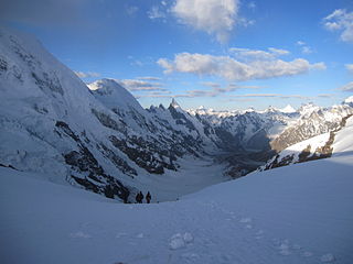
The Baltoro Glacier is a glacier located in the Shigar District of the Gilgit-Baltistan region in Pakistan. It stretches for 63 km (39 mi) in length. It is one of the longest glaciers outside the polar regions. It is home to some of the world’s highest mountains. It runs through the Karakoram mountain range, close to K2, which is the second highest peak in the world, reaching an elevation of 8,611 meters. Within a 20-kilometer radius, there are three more mountains with elevations exceeding 8,000 meters.

Askole, Askoli, or Askoly is a small town located in Shigar Valley, in the Gilgit–Baltistan region of Pakistan. Askole is located in a remote region of the Karakoram mountains 3,040 meters above sea level. It is notable for being the final settlement before one enters the wilderness of the high Karakorams.

Central Karakoram National Park is a national park located in Skardu district of Gilgit-Baltistan in Pakistan. It encompasses some of the world’s highest peaks and largest glaciers. Internationally renowned for mountaineering, rock climbing and trekking opportunities, it covers an area of about 10,000 sq. km and contains the greatest concentration of high mountains on earth. It has four peaks over 8,000 m including K2 (8611 m), Gasherbrum-I (8068 m), Gasherbrum-II (8035 m) and Broad Peak (8051 m), and sixty peaks higher than 7,000 m. The park was placed on the World Heritage Site Tentative List in 2016.
The Godwin-Austen Glacier is a glacier in the Karakoram range and is close to K2, the highest mountain peak in Pakistan and second highest on Earth, in Gilgit–Baltistan, Pakistan. Its confluence with the Baltoro Glacier is called Concordia and is a popular trekking destination as it provides views of four of the five eight-thousanders in the region.

The Saltoro Mountains form a subrange within the Karakoram Range and are situated in the southeastern part of the Karakoram. They lie on the southwest side of the Siachen Glacier, which is one of the two longest glaciers in the world outside the polar regions. The name "Saltoro" is also associated with the Saltoro Valley, located west of this range and descending on the Pakistani side of the Saltoro Range, which generally follows the Actual Ground Position Line (AGPL).

Gasherbrum V is a mountain in the Gasherbrum massif, located in the Karakoram range of Gilgit–Baltistan, Pakistan.

Gilgit-Baltistan is an administrative territory of Pakistan in the northern part of the country. It was given self-governing status on August 29, 2009. Gilgit-Baltistan comprises 14 districts within three divisions. The four districts of Skardu Kharmang Shigar and Ghanche are in the Baltistan Division, four districts of Gilgit Ghizer Hunza and Nagar districts which were carved out of Gilgit District are in the Gilgit Division and the third division is Diamir, comprising Chilas and Astore. The main political centres are the towns of Gilgit and Skardu.
Gondogoro Pass is a mountain pass that stands at an elevation of 5585 meters. It is located in the Baltistan region of Pakistan, approximately 25 km south of the world's second-highest peak, K2. This pass serves as a connection between the Gondogoro Glacier to the southwest and the Vigne Glacier to the northeast.
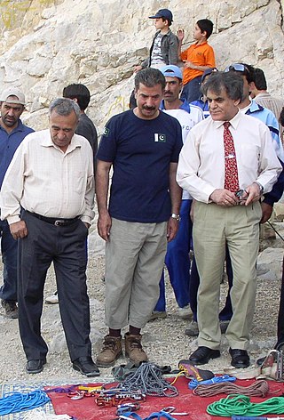
Ashraf Aman is a Pakistani mountaineer, adventurer, and engineer. In 1977, he became the first Pakistani to reach the summit of K2. He operates the travel and tourism-based company "Adventure Tours Pakistan". He is also not the vice-President of the Alpine Club of Pakistan.

Burji La is a natural pass in the Karakoram mountains between Skardu and Deosai National Park in Gilgit Baltistan, Pakistan. Its elevation is 5000 meters. It is famous especially for its beautiful panoramic view of many mountain peaks, including that of K2, Nanga Parbat, Masherbrum, Chogolisa, Laila Peak, Golden Peak, Gasherbrum I, Gasherbrum II, Gasherbrum IV and a part of Broad Peak mountain.
Tourism in Gilgit-Baltistan, an administered territory of Pakistan, focuses on its access to various mountain ranges and alpine terrain.
Drifika is a mountain peak in the Karakoram range, far west of the Transhimalaya.
References
- ↑ "Machulu la Trek :: Machulo Trek, The Shortest way to see K2, Trekking in Baltistan, Skardu Trekking Agency". tours-treks.com. Archived from the original on 2015-03-26. Retrieved 2014-09-04.
- ↑ "Travel & Tourism Articles : Hamariweb.com - کے ٹو view Point". hamariweb.com. Retrieved 2014-09-04.
| | This Pakistan location article is a stub. You can help Wikipedia by expanding it. |
| | This mountain, mountain range, or peak related article is a stub. You can help Wikipedia by expanding it. |