Madison County | |
---|---|
Coordinates: 41°20′N94°01′W / 41.33°N 94.01°W | |
Country | United States |
State | Iowa |
Founded | 1846 |
Named for | James Madison |
Seat | Winterset |
Largest city | Winterset |
Area | |
• Total | 562 sq mi (1,460 km2) |
• Land | 561 sq mi (1,450 km2) |
• Water | 1.2 sq mi (3 km2) 0.2% |
Population (2020) | |
• Total | 16,548 |
• Density | 29/sq mi (11/km2) |
Time zone | UTC−6 (Central) |
• Summer (DST) | UTC−5 (CDT) |
Congressional district | 3rd |
Website | madisoncounty |
Madison County is a county located in the U.S. state of Iowa. As of the 2020 census, the population was 16,548. [1] The county seat is Winterset. [2]
Madison County is included in the Des Moines – West Des Moines, IA Metropolitan Statistical Area. [3]
Madison County is famous for being the county where John Wayne was born, and for a number of covered bridges. These bridges were featured in Robert James Waller's 1992 novella The Bridges of Madison County , as well as the 1995 film and 2014 musical based on it.
Madison County was formed on January 13, 1846. It has been self-governed since 1849. It was named after James Madison (1751–1836), the fourth President of the United States (between 1809 and 1817). [4] Hiram Hurst was the first European-American settler in Madison County, having come from Missouri about April 15, 1846. [5]
According to the U.S. Census Bureau, the county has a total area of 562 square miles (1,460 km2), of which 561 square miles (1,450 km2) is land and 1.2 square miles (3.1 km2) (0.2%) is water. [6]
Census | Pop. | Note | %± |
---|---|---|---|
1850 | 1,179 | — | |
1860 | 7,339 | 522.5% | |
1870 | 13,884 | 89.2% | |
1880 | 17,224 | 24.1% | |
1890 | 15,977 | −7.2% | |
1900 | 17,710 | 10.8% | |
1910 | 15,621 | −11.8% | |
1920 | 15,020 | −3.8% | |
1930 | 14,331 | −4.6% | |
1940 | 14,525 | 1.4% | |
1950 | 13,131 | −9.6% | |
1960 | 12,295 | −6.4% | |
1970 | 11,558 | −6.0% | |
1980 | 12,597 | 9.0% | |
1990 | 12,483 | −0.9% | |
2000 | 14,019 | 12.3% | |
2010 | 15,679 | 11.8% | |
2020 | 16,548 | 5.5% | |
2023 (est.) | 16,971 | [7] | 2.6% |
U.S. Decennial Census [8] 1790-1960 [9] 1900-1990 [10] 1990-2000 [11] 2010-2018 [12] |
The 2020 census recorded a population of 16,548 in the county, with a population density of 29.3556/sq mi (11.3343/km2). 95.99% of the population reported being of one race. 92.42% were non-Hispanic White, 0.30% were Black, 1.91% were Hispanic, 0.15% were Native American, 0.51% were Asian, 0.08% were Native Hawaiian or Pacific Islander and 4.63% were some other race or more than one race. There were 6,913 housing units, of which 6,436 were occupied. [1]
The 2010 census recorded a population of 15,679 in the county, with a population density of 27.9413/sq mi (10.7882/km2). There were 6,554 housing units, of which 6,025 were occupied. [13]
As of the census [14] of 2000, there were 14,019 people, 5,326 households, and 3,925 families in the county. The population density was 25 inhabitants per square mile (9.7/km2). There were 5,661 housing units at an average density of 10 per square mile (3.9/km2). The racial makeup of the county was 98.57% White, 0.09% Black or African American, 0.27% Native American, 0.18% Asian, 0.02% Pacific Islander, 0.19% from other races, and 0.68% from two or more races. 0.75% of the population were Hispanic or Latino of any race.
Of the 5,326 households 34.80% had children under the age of 18 living with them, 63.90% were married couples living together, 7.00% had a female householder with no husband present, and 26.30% were non-families. 22.70% of households were one person and 11.70% were one person aged 65 or older. The average household size was 2.58 and the average family size was 3.04.
The age distribution was 27.10% under the age of 18, 6.90% from 18 to 24, 27.40% from 25 to 44, 23.40% from 45 to 64, and 15.20% 65 or older. The median age was 38 years. For every 100 females, there were 97.40 males. For every 100 females age 18 and over, there were 93.10 males.
The median household income was $41,845 and the median family income was $48,289. Males had a median income of $31,126 versus $24,095 for females. The per capita income for the county was $19,357. About 4.60% of families and 6.70% of the population were below the poverty line, including 6.60% of those under age 18 and 10.40% of those age 65 or over.
There are six extant covered bridges in Madison County, of the original nineteen:
The remaining covered bridges were designed by Harvey P. Jones and George K. Foster, with the following exceptions: Eli Cox built the Cutler-Donahoe Bridge, and J. P. Clark built the Imes Bridge.
Madison County is home to the only highway tunnel in Iowa, Harmon Tunnel, through the neck of an incised meander of the Middle River in Pammel Park. [15]
The population ranking of the following table is based on the 2020 census of Madison County. [1]
†county seat
Rank | City/Town/etc. | Municipal type | Population (2020 Census) |
---|---|---|---|
1 | † Winterset | City | 5,353 |
2 | Earlham | City | 1,410 |
3 | St. Charles | City | 640 |
4 | Truro | City | 509 |
5 | Patterson | City | 176 |
6 | East Peru | City | 115 |
7 | Macksburg | City | 97 |
8 | Bevington (partially in Warren County ) | City | 57 |
For most of its history, Madison County has primarily supported the Republican Party in presidential elections. From 1880 to 1960, the county only failed to back the party's candidate in 1932 when Herbert Hoover was defeated in a national landslide for reelection by Franklin D. Roosevelt. The county was much more of a swing area between 1964 & 1996, voting for the national winner in every presidential election between 1964 & 2004 aside from 1988 when Michael Dukakis was boosted to an inflated margin of victory statewide by a farm crisis. Since the start of the second millennium, Republicans have carried the county in every presidential election. Donald Trump also produced the county's strongest Republican presidential victory since 1952 in 2016, winning by a margin of over 30 percent.
Year | Republican | Democratic | Third party | |||
---|---|---|---|---|---|---|
No. | % | No. | % | No. | % | |
2020 | 6,507 | 66.24% | 3,134 | 31.90% | 183 | 1.86% |
2016 | 5,360 | 62.07% | 2,678 | 31.01% | 598 | 6.92% |
2012 | 4,638 | 54.84% | 3,630 | 42.92% | 190 | 2.25% |
2008 | 4,579 | 53.99% | 3,733 | 44.02% | 169 | 1.99% |
2004 | 4,538 | 56.70% | 3,380 | 42.23% | 86 | 1.07% |
2000 | 3,662 | 52.55% | 3,093 | 44.38% | 214 | 3.07% |
1996 | 2,550 | 40.30% | 3,070 | 48.52% | 707 | 11.17% |
1992 | 2,421 | 39.37% | 2,525 | 41.06% | 1,203 | 19.56% |
1988 | 2,410 | 41.11% | 3,421 | 58.36% | 31 | 0.53% |
1984 | 3,168 | 50.60% | 3,067 | 48.99% | 26 | 0.42% |
1980 | 3,320 | 51.79% | 2,496 | 38.93% | 595 | 9.28% |
1976 | 2,681 | 45.36% | 3,109 | 52.61% | 120 | 2.03% |
1972 | 3,480 | 59.35% | 2,234 | 38.10% | 150 | 2.56% |
1968 | 3,151 | 55.49% | 2,192 | 38.60% | 336 | 5.92% |
1964 | 2,250 | 38.93% | 3,518 | 60.87% | 12 | 0.21% |
1960 | 3,804 | 58.26% | 2,722 | 41.69% | 3 | 0.05% |
1956 | 3,883 | 59.34% | 2,652 | 40.53% | 9 | 0.14% |
1952 | 4,967 | 69.48% | 2,131 | 29.81% | 51 | 0.71% |
1948 | 3,207 | 52.38% | 2,827 | 46.17% | 89 | 1.45% |
1944 | 3,737 | 59.20% | 2,550 | 40.39% | 26 | 0.41% |
1940 | 4,477 | 58.91% | 3,094 | 40.71% | 29 | 0.38% |
1936 | 4,188 | 55.04% | 3,365 | 44.22% | 56 | 0.74% |
1932 | 2,663 | 47.09% | 2,923 | 51.69% | 69 | 1.22% |
1928 | 4,364 | 66.15% | 2,178 | 33.02% | 55 | 0.83% |
1924 | 4,191 | 60.80% | 1,367 | 19.83% | 1,335 | 19.37% |
1920 | 4,465 | 68.83% | 1,899 | 29.27% | 123 | 1.90% |
1916 | 1,871 | 51.26% | 1,711 | 46.88% | 68 | 1.86% |
1912 | 1,274 | 33.79% | 1,185 | 31.43% | 1,311 | 34.77% |
1908 | 2,425 | 59.54% | 1,404 | 34.47% | 244 | 5.99% |
1904 | 2,602 | 63.20% | 1,190 | 28.90% | 325 | 7.89% |
1900 | 2,590 | 55.67% | 1,907 | 40.99% | 155 | 3.33% |
1896 | 2,313 | 50.28% | 2,224 | 48.35% | 63 | 1.37% |
Guernsey County is a county located in the U.S. state of Ohio. As of the 2020 census, the population was 38,438. Its county seat and largest city is Cambridge. It is named for the Isle of Guernsey in the English Channel, from which many of the county's early settlers emigrated.
Worth County is a county located in the U.S. state of Iowa. As of the 2020 census, the population was 7,443. The county seat is Northwood. The county was founded in 1851 and named for Major General William Jenkins Worth (1794–1849), an officer in both the Seminole War and the Mexican–American War.
Union County is a county located in the southern part of the U.S. state of Iowa. As of the 2020 Census, the population was 12,138. The county seat is Creston. Organized at a time of tensions before the Civil War, the county was named in 1853 for the union that people wanted to preserve. Union County peaked in population at the 1900 Census. Its economy is based on agriculture and related industries.
Sioux County is a county located in the U.S. state of Iowa. As of the 2020 census, the population was 35,872. Its county seat is Orange City. Its largest city is Sioux Center.
Ringgold County is a county located in the U.S. state of Iowa. As of the 2020 census, the population was 4,663, making it the Iowa county with the second-smallest population. The county seat is Mount Ayr. The county is named after Maj. Samuel Ringgold, a hero of the Battle of Palo Alto fought in May 1846, during the Mexican–American War. It is one of the 26 Iowa counties with a name that is unique across the nation.
Polk County is located in the U.S. state of Iowa. As of the 2020 census, the population was 492,401. It is Iowa's most populous county, and home to over 15% of the state's residents. The county seat is Des Moines, which is also the capital city of Iowa. Polk County is included in the Des Moines–West Des Moines, IA Metropolitan Statistical Area.
Palo Alto County is a county located in the U.S. state of Iowa. As of the 2020 census, the population was 8,996. The county seat is Emmetsburg. It is named after the Battle of Palo Alto, the first major battle of the Mexican–American War.
Johnson County is located in the U.S. state of Iowa. As of the 2020 census, the population was 152,854, making it the fourth-most populous county in Iowa. The county seat is Iowa City, home of the University of Iowa. Johnson County is included in the Iowa City metropolitan area, which is also included in the Cedar Rapids-Iowa City Corridor Combined Statistical Area.
Jefferson County is a county located in the U.S. state of Iowa. As of the 2020 United States Census, the population was 15,663. The county seat is Fairfield. The county was formed in January 1839, and was named for U.S. President Thomas Jefferson.
Clarke County is a county located in the U.S. state of Iowa. As of the 2020 census, the population was 9,748. The county seat is Osceola. The county was formed in January 1846, one of twelve counties established by legislative action in a comprehensive act. It was named for James Clarke, a Governor of the Iowa Territory.
Boone County is a county in the U.S. state of Iowa. As of the 2020 census, the population was 26,715. Its county seat is Boone.
Madison County is a county located in the U.S. state of Idaho. As of the 2020 census, the population was 52,913. The county seat and largest city is Rexburg.
Madison is a city in Madison and St. Clair counties in the U.S. state of Illinois. The population was 3,171 at the 2020 census, down from 3,891 in 2010. It is home to World Wide Technology Raceway at Gateway and the first Bulgarian Orthodox church in the United States.
Dunkerton is a city in Black Hawk County, Iowa, United States. The population was 842 at the time of the 2020 census. It is part of the Waterloo–Cedar Falls Metropolitan Statistical Area.
Jefferson is a city in, and the county seat of Greene County, Iowa, United States, along the North Raccoon River. The population was 4,182 at the time of the 2020 census. It is the home of the Mahanay Memorial Bell Tower, 168 feet (51 m) tall, located on the town square, and visible for miles. The tower is named for Floyd Mahanay, a businessman, philanthropist, and former resident. Jefferson is bisected east to west by the old Lincoln Highway. A new U.S. Route 30 is located approximately one mile to the north.
East Peru is a city in Madison County, Iowa, United States. The population was 115 at the time of the 2020 census. It is part of the Des Moines–West Des Moines Metropolitan Statistical Area.
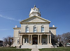
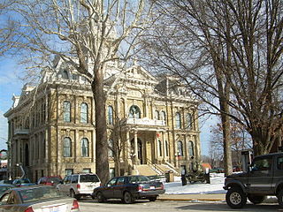
Winterset is a city in and the county seat of Madison County, Iowa. The population was 5,353 at the time of the 2020 census.
Alexandria is a city in eastern Clark County, Missouri, United States. As of the 2020 census, its population was 105.
Madison Township is a township in Armstrong County, Pennsylvania, United States. The population was 826 at the 2020 census, an increase over the figure of 820 tabulated in 2010.
Surf City is a town in Onslow and Pender counties in the U.S. state of North Carolina. The population was 3,867 at the 2020 census. It is located on Topsail Island.