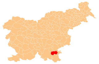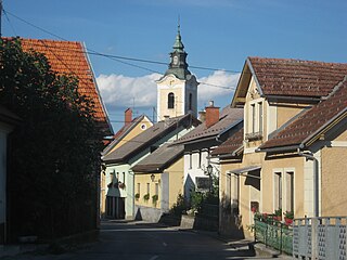
Semič is a settlement in southeastern Slovenia. It is the administrative centre of the Municipality of Semič.

Gorenji Vrh pri Dobrniču is a small village in the Municipality of Trebnje in eastern Slovenia. The area is part of the historical region of Lower Carniola. The municipality is now included in the Southeast Slovenia Statistical Region. The nucleated village was built around a small pond in the 18th century and is included on the list of cultural monuments published by the Ministry of Culture of the Republic of Slovenia.

Gradišče pri Trebnjem is a village in the Municipality of Trebnje in eastern Slovenia. The area is part of the historical region of Lower Carniola. The municipality is now included in the Southeast Slovenia Statistical Region.
Blatnik pri Črmošnjicah is a small settlement in the Municipality of Semič in Slovenia. It was inhabited by Gottschee Germans that were mostly expelled in 1941 during the Second World War. The area is part of the historical region of Lower Carniola. The municipality is now included in the Southeast Slovenia Statistical Region.
Brezje pri Vinjem Vrhu is a settlement in the hills south of Semič in southeastern Slovenia. The area is part of the historical region of Lower Carniola. The Municipality of Semič is now included in the Southeast Slovenia Statistical Region.
Brezova Reber is a small settlement in the Municipality of Semič in Slovenia. The area is part of the historical region of Lower Carniola. The municipality is now included in the Southeast Slovenia Statistical Region.
Gradnik is a village in the Municipality of Semič in Slovenia. The area is part of the historical region of Lower Carniola. The municipality is now included in the Southeast Slovenia Statistical Region.

Kal is a village in the Municipality of Semič in Slovenia. The area is part of the historical region of Lower Carniola. The municipality is now included in the Southeast Slovenia Statistical Region.
Krvavčji Vrh is a village in the Municipality of Semič in Slovenia. It lies on the local road leading east out of Semič to Metlika. The area is part of the historical region of Lower Carniola. The municipality is now included in the Southeast Slovenia Statistical Region.
Rožni Dol is a village in the Municipality of Semič in Slovenia. The area is part of the historical region of Lower Carniola. The municipality is now included in the Southeast Slovenia Statistical Region.
Sodji Vrh is a small settlement just north of the village of Gradnik in the Municipality of Semič in Slovenia. The area is part of the historical region of Lower Carniola. The municipality is now included in the Southeast Slovenia Statistical Region.
Srednja Vas is a village in the Municipality of Semič in Slovenia. The area is part of the historical region of Lower Carniola. The municipality is now included in the Southeast Slovenia Statistical Region.
Stranska Vas pri Semiču is a village on the right bank of the Krupa River in the Municipality of Semič in Slovenia. The area is part of the historical region of Lower Carniola. The municipality is now included in the Southeast Slovenia Statistical Region.

Vinji Vrh pri Semiču is a village in the Municipality of Semič in southeastern Slovenia. The area is part of the historical region of Lower Carniola. The municipality is now included in the Southeast Slovenia Statistical Region.
Sela pri Ajdovcu is a small village in the Municipality of Žužemberk in southeastern Slovenia. The area is part of the historical region of Lower Carniola. The municipality is now included in the Southeast Slovenia Statistical Region.
Vrh pri Križu is a village in the Municipality of Žužemberk in southeastern Slovenia. It lies above the left bank of the Krka River northwest of Žužemberk. The area is part of the historical region of Lower Carniola. The municipality is now included in the Southeast Slovenia Statistical Region.
Dob pri Šentvidu is a village in the Municipality of Ivančna Gorica in central Slovenia. It lies east of Ivančna Gorica and the A2 motorway runs across the settlement territory to the south of the village core. The area is part of the historical region of Lower Carniola. The municipality is now included in the Central Slovenia Statistical Region.
Gabrovka pri Zagradcu is a village north of Zagradec in the Municipality of Ivančna Gorica in central Slovenia. The area is part of the historical region of Lower Carniola. The municipality is now included in the Central Slovenia Statistical Region.
Sela pri Višnji Gori is a small village in the hills northeast of Višnja Gora in the Municipality of Ivančna Gorica in central Slovenia. The area is part of the historical region of Lower Carniola. The municipality is now included in the Central Slovenia Statistical Region.