
Douglas Island is a tidal island in the U.S. state of Alaska, just west of downtown Juneau and east of Admiralty Island. It is separated from mainland Juneau by the Gastineau Channel.
The Juneau Empire is a newspaper in Juneau, Alaska, United States.

The Mendenhall Valley is the drainage area of the Mendenhall River in the U.S. state of Alaska. The valley contains a series of neighborhoods, comprising the largest populated place within the corporate limits of the City and Borough of Juneau, Alaska's capital.
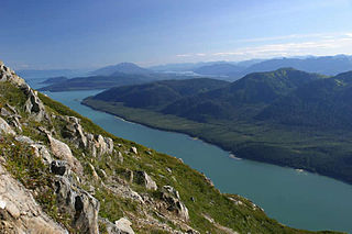
Gastineau Channel is a channel between the mainland of the U.S. state of Alaska and Douglas Island in the Alexander Archipelago of southeastern Alaska. It separates Juneau on the mainland side from Douglas, on Douglas Island. The first European to sight the channel was Joseph Whidbey early in August 1794, first from the south and later from the west. It was probably named for John Gastineau, an English civil engineer and surveyor.

The Alaska Senate is the upper house in the Alaska Legislature, the state legislature of the U.S. state of Alaska. It convenes in the Alaska State Capitol in Juneau, Alaska and is responsible for making laws and confirming or rejecting gubernatorial appointments to the state cabinet, commissions and boards.
The Alaska House of Representatives is the lower house in the Alaska Legislature, the state legislature of the U.S. state of Alaska. The House is composed of 40 members, each of whom represents a district of approximately 17,756 people per 2010 Census figures. Members serve two-year terms without term limits. With 40 representatives, the Alaska House is the smallest state legislative lower house in the United States.
Mount Furuhelm is a 3,620 foot peak located on Baranof Island just east and adjacent to Peak 5390 in Alaska. It is located at 57°03′00″N134°55′47″W.
Coronation Island Wilderness is a 19,232-acre (7,783 ha) wilderness area in the U.S. state of Alaska. It was designated by the United States Congress in 1980 in a provision of the Alaska National Interest Lands Conservation Act. The wilderness area encompasses the entirety of Coronation Island plus the Spanish Islands. It is part of Tongass National Forest, which is managed by the United States Forest Service.

Lincoln Island is a wooded island in Lynn Canal in Alaska, United States. Located at 58°29′41″N134°59′40″W, the island is one kilometer northwest of larger Shelter Island and some 200 meters southeast of smaller Ralston Island. It is part of the Juneau City and Borough. The first European to sight the island was Joseph Whidbey, master of HMS Discovery during George Vancouver's 1791–1795 expedition, in 1794. It was named in 1868 by Commander R. W. Meade, USN, presumably for Abraham Lincoln.

KXLL is a non-commercial adult album alternative/modern rock hybrid music radio station in Juneau, Alaska, broadcasting on 100.7 FM.
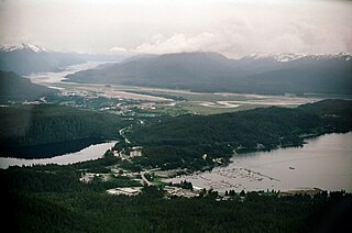
Auke Bay is an unincorporated community located in the city and borough of Juneau, Alaska that contains Auke Bay Harbor, Auke Lake, the University of Alaska Southeast, an elementary school, a church, a post office, a bar, a coffee shop, a waffle house, a thrift shop, a Thai restaurant, and one convenience store. The view of the Mendenhall Glacier behind Auke Bay and Mount McGinnis towering over Auke Lake are some of the most popular photo opportunities in Juneau. The ferry terminal of the Alaska Marine Highway system is also located further out the road in Auke Bay at about 14 mile. The flamingo house on Auke Lake is a local attraction, known for its topical or weather-related formations of pink lawn flamingos. Whale watchings targeting curious humpbacks are available. Humpbacks in these areas are known to demonstrate special feeding methods, so-called 'Bubble-net feeding', and come very close to shores.
Lena Beach is a populated place in Juneau, Alaska, United States. The name was first published by the Bureau of the Census in 1940 and entered into the Geographic Names Information System on March 23, 2001. It is 14 miles (23 km) northwest of the city of Juneau.

Tee Harbor refers to two adjacent populated places in the City and Borough of Juneau, Alaska. The area had a population of 32 in 1950. It is located 3 miles (4.8 km) northwest of Fairhaven and 17 miles (27 km) northwest of the main city of Juneau.

Shelter Island is an island in the Alexander Archipelago, southeast of Lincoln Island and northwest of Juneau, Alaska, U.S. It trends northwest between Favorite and Saginaw channels. It was named in 1869 by Commander R. W. Meade of the United States Navy. The first European to sight the island was Joseph Whidbey, master of HMS Discovery during George Vancouver's 1791–95 expedition, in 1794.
Favorite Channel is a channel in Southeast Alaska, northwest of Juneau, Alaska, United States. It is 25 kilometres (16 mi) long, extending northwest from Stephens Passage to Lynn Canal, separating Lincoln and Shelter islands from the mainland to the east. It was named in 1880 by U.S. Navy officers after the 80-foot (24 m) steamboat Favorite, which was chartered by the Navy for surveying work in Alaska, later being used to carry out trading and fishing for the herring plant at Killisnoo. The first European to traverse and chart the channel was Joseph Whidbey, master of HMS Discovery during George Vancouver's 1791–95 expedition, in 1794.

The Alaska State Museum is a museum in Juneau, Alaska, United States. After a $139m renovation, it re-opened after a two-year and three-month closure. The museum closed temporarily on February 28, 2014 for the creation of a new facility that joined the State Libraries, Archives and Museum (SLAM) together in a comprehensive research facility. The old structure, designed by Linn A. Forrest, was demolished in August 2014, and a new facility opened on the same footprint, on June 6, 2016. The new building was named after the first curator for the Alaska State Museum, the Russian Orthodox priest, Father Andrew P. Kashevaroff. This building is also known as the APK.

Taku Inlet is an inlet located in the U.S. state of Alaska. It extends 18 miles (29 km) in a northeast direction from Stephens Passage in the Alexander Archipelago, about 12 kilometres (7.5 mi) southeast of Juneau, widening to a basin where discharge from the Taku River and Taku Glacier emerges.

Gold Creek is a waterway in the southeastern section of the U.S. state of Alaska. It is located in Silver Bow Basin at the edge of Juneau. In 1880, Chief Kowee revealed to prospectors Joe Juneau and Richard Harris the presence of gold in Gold Creek; the city of Juneau was founded in the same year. Named by miners, it was first published in 1883.
There are 21 mountain peaks named West Peak in the United States according to the US Geological Survey Geographic Names Information System.
Amalga is a former gold-mining town outside of Juneau, Alaska. The area is now part of the Tongass National Forest. The Library of Congress has a photograph of Amalga by Winter & Pond in its collection. The area was once homesteaded and farmed. A horse tram brought goods delivered by steamship to the mine.

