
Espoo is a city and municipality in the region of Uusimaa in the Republic of Finland. It is located on the northern shore of the Gulf of Finland, bordering the cities of Helsinki and Vantaa, while surrounding the enclaved town of Kauniainen. The city covers 528.03 square kilometres (203.9 sq mi) with a population of 292,913 residents in December 2020, making it the 2nd-most populous city in Finland. Espoo forms a major part of a substantially larger metropolitan area known as Greater Helsinki, home to over 1.5 million people in 2020.

Tintagel Castle is a medieval fortification located on the peninsula of Tintagel Island adjacent to the village of Tintagel (Trevena), North Cornwall in the United Kingdom. The site was possibly occupied in the Romano-British period, as an array of artefacts dating from this period have been found on the peninsula, but as yet no Roman-era structure has been proven to have existed there. It was settled during the early medieval period, when it was probably one of the seasonal residences of the regional king of Dumnonia. A castle was built on the site by Richard, 1st Earl of Cornwall in the 13th century, during the High Middle Ages. It later fell into disrepair and ruin.

Glastonbury Abbey was a monastery in Glastonbury, Somerset, England. Its ruins, a grade I listed building and scheduled ancient monument, are open as a visitor attraction.
Radley is a village and civil parish about 2 miles (3 km) northeast of the centre of Abingdon, Oxfordshire. The parish includes the hamlet of Lower Radley on the River Thames. It was part of Berkshire until the 1974 boundary changes transferred it to Oxfordshire. The village is home to Radley College, a famous boarding independent school for boys from the age of thirteen to eighteen that consists of 690 pupils.
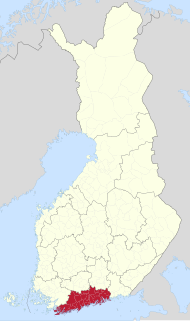
Uusimaa is a region of Finland. It borders the regions of Southwest Finland, Tavastia Proper (Kanta-Häme), Päijänne Tavastia (Päijät-Häme), and Kymenlaakso. Finland's capital and largest city, Helsinki, along with the surrounding Greater Helsinki area, are both contained in the region, and Uusimaa is Finland's most populous region. The population of Uusimaa is 1,703,649.

Headcorn is a village and civil parish in the borough of Maidstone in Kent, England. The parish is on the floodplain of the River Beult south east of Maidstone.

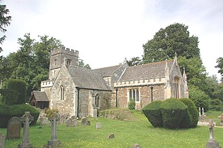
The Abbey of St Mary is a ruined Benedictine abbey in York, England and a Grade I listed building.

Länsimetro is an extension to the Helsinki Metro system in Finland. The grand opening for the long-awaited extension was held on 18 November 2017. Länsimetro extends the system's two lines, M1 and M2, from Central Helsinki to the neighbouring city of Espoo. The new stretch continues the lines from the existing Ruoholahti station via the island of Lauttasaari, the Aalto University Otaniemi campus and Tapiola, the terminus of line M2. Line M1 continues further west to Matinkylä. Unlike previous extensions to the Helsinki Metro system, Länsimetro runs entirely underground. The second phase is scheduled to open in 2023, and will continue the line further west to Kivenlahti.

Tormarton is a village in South Gloucestershire, England. Its name may come from Thor Maer Tun meaning The settlement with the thorn (tree) on the boundary. Another source suggests the name derives from the church tower (Tor) on the border between Wessex and Mercia. It is one mile North-East of junction 18 of the M4 motorway, with the A46 road and close to the border between Wiltshire and South Gloucestershire. In 2001 and 2011 there were 144 households and the population was 348. A National Trail, the Cotswold Way passes through the village. There is a church, a hotel, a pub and also a number of bed and breakfasts in the village. A Highways Agency depot with a salt dome is situated near to the village.
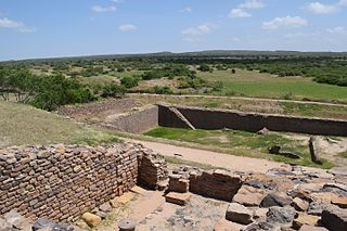
Dholavira is an archaeological site at Khadirbet in Bhachau Taluka of Kutch District, in the state of Gujarat in western India, which has taken its name from a modern-day village 1 kilometre (0.62 mi) south of it. This village is 165 km (103 mi) from Radhanpur. Also known locally as Kotada timba, the site contains ruins of an ancient Indus Valley Civilization/Harappan city. Dholavira’s location is on the Tropic of Cancer. It is one of the five largest Harappan sites and most prominent archaeological sites in India belonging to the Indus Valley Civilization. It is also considered as having been the grandest of cities of its time. It is located on Khadir bet island in the Kutch Desert Wildlife Sanctuary in the Great Rann of Kutch. The 47 ha quadrangular city lay between two seasonal streams, the Mansar in the north and Manhar in the south. The site was thought to be occupied from c.2650 BCE, declining slowly after about 2100 BCE, and to have been briefly abandoned then reoccupied until c.1450 BCE; however, recent research suggests the beginning of occupation around 3500 BCE (pre-Harappan) and continuity until around 1800 BCE.

Among the early Germanic peoples, a mead hall or feasting hall was initially simply a large building with a single room. From the fifth century to the Early Middle Ages such a building was the residence of a lord and his retainers. These structures were also where lords could formally receive visitors and where the community would gather to socialize, allowing lords to oversee the social activity of their subjects. The mead hall was generally the great hall of the king.

The Azykh Cave is a six-cave complex known as a habitation site of prehistoric humans. It lies near the village of Azykh in the Khojavend District of Azerbaijan.

Rhynie is a village in Aberdeenshire, Scotland. It is on the A97 road, 14 miles (23 km) northwest of Alford.

Mathilakam is a village in Kodungallur taluk, Thrissur district in Kerala, south India. It is located around 5 miles north of Kodungallur on National Highway 66.

Tel Jezreel is an archaeological site in the eastern Jezreel Valley in northern Israel. The city of Jezreel served as a main fortress of the Kingdom of Israel under king Ahab in the 9th century BCE.

Daimabad is a deserted village and an archaeological site on the left bank of the Pravara River, a tributary of the Godavari River in Shrirampur taluka in Ahmednagar district of Maharashtra state in India. This site was discovered by B. P. Bopardikar in 1958. It has been excavated three times so far by the Archaeological Survey of India teams. The first excavation in 1958-59 was carried out under the direction of M. N. Deshpande. The second excavation in 1974-75 was led by S. R. Rao. Finally, the excavations between 1975-76 and 1978-79 were carried out under the direction of S. A. Sali. Discoveries at Daimabad suggest that Late Harappan culture extended into the Deccan Plateau in India. Daimabad is famous for the recovery of many bronze goods, some of which were influenced by the Harappan culture.

Buzeyir cave – is an archaeological site and Paleolithic place of human habitation. The cave is located on the left bank of the Zuvandchay River, at the top of Delikli-Dash Mountain, 3 km (1.9 mi) at an altitude of 1,640 m (5,380 ft) above sea level and to the east of Büzeyir village in Lerik Rayon, Azerbaijan.

Chirand is an archaeological site in the Saran district of Bihar, India, situated on the northern bank of the Ganga River. It has a large pre-historic mound which is known for its continuous archaeological record from the Neolithic age to the reign of the Pal dynasty who ruled during the pre-medieval period. The excavations in Chirand have revealed stratified Neolithic, Chalcolithic, and Iron Age settlements, and transitions in human habitation patterns dating from 2500 BC to 30 AD.
This page lists major archaeological events of 2017.
