
Guglielmo Giovanni Maria Marconi, 1st Marquis of Marconi was an Italian inventor and electrical engineer, known for his creation of a practical radio wave–based wireless telegraph system. This led to Marconi being credited as the inventor of radio, and he shared the 1909 Nobel Prize in Physics with Karl Ferdinand Braun "in recognition of their contributions to the development of wireless telegraphy".

Marin County is located in the northwestern part of the San Francisco Bay Area of the U.S. state of California. As of the 2020 census, the population was 262,231. Its county seat and largest city is San Rafael. Marin County is across the Golden Gate Bridge from San Francisco, and is included in the San Francisco–Oakland–Berkeley, CA Metropolitan Statistical Area.

Bolinas is an unincorporated coastal community and census-designated place in Marin County, California, United States. As of the 2020 census it had a population of 1,483. It is located on the California coast, approximately 13 miles (21 km) northwest of San Francisco, and 27 miles (43 km) by road.

Point Reyes National Seashore is a 71,028-acre (287.44 km2) park preserve located on the Point Reyes Peninsula in Marin County, California. As a national seashore, it is maintained by the US National Park Service as an important nature preserve. Some existing agricultural uses are allowed to continue within the park. Clem Miller, a US Congressman from Marin County, wrote and introduced the bill for the establishment of Point Reyes National Seashore in 1962 to protect the peninsula from development which was proposed at the time for the slopes above Drake's Bay.
Point Reyes is a prominent cape and popular Northern California tourist destination on the Pacific coast. Located in Marin County, it is approximately 30 miles (50 km) west-northwest of San Francisco. The term is often applied to the Point Reyes Peninsula, the region bounded by Tomales Bay on the northeast and Bolinas Lagoon on the southeast. The majority of the peninsula as well as the headlands are protected as part of Point Reyes National Seashore.

Tomales Bay is a long, narrow inlet of the Pacific Ocean in Marin County in northern California in the United States. It is approximately 15 mi (24 km) long and averages nearly 1.0 mi (1.6 km) wide, effectively separating the Point Reyes Peninsula from the mainland of Marin County. It is located approximately 30 mi (48 km) northwest of San Francisco. The bay forms the eastern boundary of Point Reyes National Seashore. Tomales Bay is recognized for protection by the California Bays and Estuaries Policy. On its northern end, it opens out onto Bodega Bay, which shelters it from the direct current of the Pacific. The bay is formed along a submerged portion of the San Andreas Fault.

Mount Tamalpais, known locally as Mount Tam, is a peak in Marin County, California, United States, often considered symbolic of Marin County. Much of Mount Tamalpais is protected within public lands such as Mount Tamalpais State Park, the Marin Municipal Water District watershed, and National Park Service land, such as Muir Woods.

The Marconi National Historic Site and the Marconi Wireless Station National Historic Site are two National Historic Sites located on Cape Breton Island, Nova Scotia. Both sites commemorate the efforts of Guglielmo Marconi to transmit transatlantic radio signals between North America and Europe in the first decade of the 20th century. The two sites are located within approximately 8 kilometres (5.0 mi) of one another, and are connected by the Marconi Trail.
Camp Evans Historic District is an area of the Camp Evans Formerly Used Defense Site in Wall Township, New Jersey. The site of the military installation is noted for a 1914 transatlantic radio receiver and various World War II/Cold War laboratories of the United States Army. It was designated a National Historic Landmark District in 2012, in recognition of the site's long role in the development of modern civilian and military electronic communications.
WCC was the busiest coast station in the public ship-to-shore radio service for most of the 20th century.

The Point Reyes Lighthouse, also known as Point Reyes Light or the Point Reyes Light Station, is a lighthouse in the Gulf of the Farallones on Point Reyes in Point Reyes National Seashore, located in Marin County, California, United States.

Point Bonita Lighthouse is a lighthouse located at Point Bonita at the San Francisco Bay entrance in the Marin Headlands near Sausalito, California. Point Bonita was the last staffed lighthouse on the California coast. It was added to the National Register of Historic Places in 1991.

Dogtown is an unincorporated community in the rural West Marin region of coastal Marin County, California in the San Francisco Bay Area's North Bay. It lies at an elevation of 187 feet. With a population of 30, the town is located beside the Golden Gate National Recreation Area and Point Reyes National Seashore, in the Olema Valley west of the Bolinas Ridge mountain range.

Point Reyes Lifeboat Station, also known as Point Reyes Lifeboat Rescue Station, is a historic coastal rescue station, located on the Drake's Bay side of Point Reyes in northern California, United States. It was built in 1927 by the United States Lifesaving Service to replace a previous station dating from 1888. It is one of the best-preserved rescue stations of that period on the Pacific coast, retaining elements often lost, including the boat launching infrastructure. It is now a historic property managed by the National Park Service as part of Point Reyes National Seashore. It was listed on the National Register of Historic Places in 1985, and it was further declared a National Historic Landmark in 1989.

Marconi is an unincorporated community in Marin County, California. It is located on the northeast shore of Tomales Bay, about seven miles (11 km) south-southeast of the village of Tomales, at an elevation of about 70 feet above sea level. Marconi is located in the area of the town of Marshall, California.

KPH is a coast radio station on the Pacific Coast of the United States. For most of the 20th century, it provided ship to shore communications including telegrams and marine telex service. The station discontinued commercial operation in 1998, but is operated occasionally as a historic service – its signal can be received over a large portion of the western hemisphere.

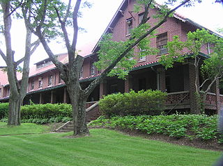
The Marconi–RCA Wireless Receiving Station is a historic district at the junction of Old Comers Rd. and Orleans Rd. in Chatham, Massachusetts. It and its companion transmitter station at Marion were used for WCC, the busiest ship to shore radio station for most of the 20th century. The district includes eight red brick buildings constructed by Marconi in 1914 to house the station's operations; it was listed on the National Register of Historic Places in 1994, and is now home to the Chatham Marconi Maritime Center museum.
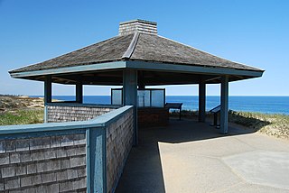
The Marconi Wireless Station Site in South Wellfleet, Massachusetts, USA is the site of the first transatlantic wireless communication between the United States of America and Europe, on January 18, 1903. At this location, now part of the Cape Cod National Seashore, inventor Guglielmo Marconi erected a large antenna array on four 210-foot (64 m) wooden towers, and established a transmitting station powered by kerosene engines that produced the 25,000 volts of electricity needed to send signals to a similar station in Poldhu, Cornwall, United Kingdom. The first transmission received on the continent of North America by Marconi was at Signal Hill, St. John's, Newfoundland and Labrador in 1901; Glace Bay, Nova Scotia was the site of the first such two-way transmission, in 1902.

The Marconi Wireless Telegraphy station is a historic structure on Oʻahu's North Shore between the towns of Kawela Bay and Kahuku. It was briefly the world's most powerful telegraph station.

