Shenandoah County is a county located in the Commonwealth of Virginia. As of the 2010 census, the population was 41,993. Its county seat is Woodstock. It is part of the Shenandoah Valley region of Virginia.

Rockingham County is a county located in the U.S. state of Virginia. As of the 2010 census, the population was 76,314. Its county seat is the independent city of Harrisonburg.

Nelson County is a county located in the Commonwealth of Virginia. As of the 2010 census, the population was 15,020. Its county seat is Lovingston.

Monroe County is a county in the U.S. state of Pennsylvania. As of the 2010 census, the population was 169,842. Its county seat is Stroudsburg. The county was formed from sections of Northampton and Pike counties. Named in honor of James Monroe, the fifth president of the United States, the county is located in northeastern Pennsylvania, along its border with New Jersey. Monroe County is coterminous with the East Stroudsburg, PA Metropolitan Statistical Area, within the Greater New York–Newark, NY–NJ–CT–PA Combined Statistical Area. It also borders the Lehigh Valley and has connections to the Delaware Valley, being a part of Philadelphia's Designated Media Market.

Massanutten Military Academy (MMA) is a coeducational military school for grades 5 through 12 and one academic postgraduate year, located in Woodstock, Virginia, United States.

The George Washington and Jefferson National Forests are U.S. National Forests that combine to form one of the largest areas of public land in the Eastern United States. They cover 1.8 million acres (7,300 km2) of land in the Appalachian Mountains of Virginia, West Virginia, and Kentucky. Approximately 1 million acres (4,000 km2) of the forest are remote and undeveloped and 139,461 acres (564 km2) have been designated as wilderness areas, which eliminates future development.

Southern West Virginia is a culturally and geographically distinct region in the U.S. state of West Virginia. Generally considered the heart of Appalachia, Southern West Virginia is known for its coal mining heritage and Southern affinity. The region is also closely identified with southwestern Virginia and southeastern Kentucky, with close proximity to northwestern North Carolina and East Tennessee. Today, Southern West Virginia continues to grapple with poverty and continuing population loss. Almost the entire region is located in West Virginia's 3rd congressional district, which was represented by Evan Jenkins until he resigned on September 30, 2018 to take a seat as a Justice on the Supreme Court of Appeals of West Virginia.

Turner Ashby High School is located in Bridgewater, Virginia in the Rockingham County Public School district.

Great North Mountain is a 50-mile (80 km) long mountain ridge within the Ridge-and-valley Appalachians in the U.S. states of Virginia and West Virginia. The ridge is located west of the Shenandoah Valley and Massanutten Mountain in Virginia, and east of the Allegheny Mountains and Cacapon River in West Virginia.

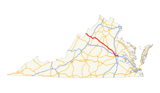
U.S. Route 33 is a part of the U.S. Highway System that runs from Elkhart, Indiana to Richmond, Virginia. In Virginia, the U.S. Highway runs 135.60 miles (218.23 km) from the West Virginia state line near Rawley Springs east to its eastern terminus at SR 33 in Richmond. US 33 is the primary east–west highway of Rockingham County, which lies in the Shenandoah Valley. The highway connects the independent city of Harrisonburg, the town of Elkton, and an entrance to Shenandoah National Park. East of the Blue Ridge Mountains, US 33 connects the Piedmont communities of Stanardsville, Gordonsville, and Louisa. The U.S. Highway is a major suburban and urban route in the Richmond metropolitan area. Within Richmond, US 33 runs concurrently with US 250. SR 33 continues from US 33's eastern terminus as a state-numbered extension of the U.S. Highway that connects Richmond with Virginia's Middle Peninsula.

The Silurian Tuscarora Formation — also known as Tuscarora Sandstone or Tuscarora Quartzite — is a mapped bedrock unit in Pennsylvania, Maryland, West Virginia, and Virginia, USA.

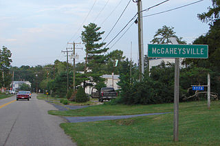
McGaheysville is an unincorporated community located in Rockingham County, in the U.S. state of Virginia. It is located along U.S. Route 33 between Penn Laird and Elkton, and sits at the base of the Massanutten.

Elizabeth Furnace was a blast furnace in the Shenandoah Valley that was used to create pig iron from 1836 – 1888 using Passage Creek for water power. Iron ore was mined nearby, purified in the furnace, and then pig iron was transported over the Massanutten Mountain to the South Fork of the Shenandoah River for forging in Harpers Ferry, West Virginia. The road used to transport this iron is still used today by hikers climbing to the top of the Massanutten Mountain via the Massanutten Trail. Much of the original stone structure still exists, as well as a restored cabin, and an outdoor recreation area.
Smith Creek is a 35.5-mile-long (57.1 km) tributary stream of the North Fork of the Shenandoah River in the Shenandoah Valley of Virginia. Its watershed comprises 106 square miles (270 km2) within Shenandoah and Rockingham counties on the western slope of the Massanutten Mountain ridge. Its headwaters lie in Rockingham County just north of Harrisonburg, and its confluence with the North Fork of the Shenandoah River is located just south of Mount Jackson.
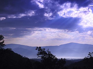
Signal Knob is the northern peak of Massanutten Mountain in the Ridge and Valley Appalachians with an elevation of 2,106 feet (642 m). It is located in George Washington National Forest in Shenandoah County and Warren County in Virginia.

Short Mountain lies along the northwestern margin of Massanutten Mountain in Shenandoah County, Virginia. It is seven miles in length, from Mount Jackson on the south end to Edinburg on the north, so it was also once known as "Seven-Mile Mountain". The Massanutten Trail traverses the mountain.


