Massasoit National Wildlife Refuge

Last updated
Massasoit National Wildlife Refuge
IUCN category IV (habitat/species management area)
Usa edcp relief location map.png
Red pog.svg
Map of the United States
Location Plymouth, Massachusetts, United States
Coordinates 41°53′19″N70°38′43″W / 41.8885°N 70.6452°W / 41.8885; -70.6452 Coordinates: 41°53′19″N70°38′43″W / 41.8885°N 70.6452°W / 41.8885; -70.6452 [1]
Area195 acres (0.79 km2)
Established1983
Governing body U.S. Fish and Wildlife Service
Website Massasoit National Wildlife Refuge

Massasoit National Wildlife Refuge was established in 1983 to conserve the federally endangered Plymouth Red-bellied Turtle, as well as other wildlife and plant species. The Refuge encompasses 195 acres (0.79 km2) in Plymouth, Massachusetts. It is made up of two parcels; the Crooked Pond parcel abuts the Myles Standish State Forest, the second largest State forest in Massachusetts, and the smaller parcel is located on the shoreline of Island Pond. Massasoit National Wildlife Refuge is located within a 3,269-acre (13.23 km2) area designated as critical habitat for the Plymouth Red-bellied Turtle.

Plymouth, Massachusetts Town in Massachusetts, United States

Plymouth is a town in Plymouth County, Massachusetts. The town holds a place of great prominence in American history, folklore, and culture, and is known as "America's Hometown." Plymouth was the site of the colony founded in 1620 by the Mayflower Pilgrims, where New England was first established. It is the oldest municipality in New England and one of the oldest in the United States. The town has served as the location of several prominent events, one of the more notable being the First Thanksgiving feast. Plymouth served as the capital of Plymouth Colony from its founding in 1620 until the colony's merger with the Massachusetts Bay Colony in 1691. It is named after Plymouth, England where the Mayflower set sail for America.

Myles Standish State Forest

Myles Standish State Forest is state forest located in the towns of Plymouth and Carver in southeastern Massachusetts, approximately 45 miles (70 km) south of Boston. It is the largest publicly owned recreation area in this part of Massachusetts and is managed by the Department of Conservation and Recreation (DCR).

Massachusetts State of the United States of America

Massachusetts, officially the Commonwealth of Massachusetts, is the most populous state in the New England region of the northeastern United States. It borders on the Atlantic Ocean to the east, the states of Connecticut and Rhode Island to the south, New Hampshire and Vermont to the north, and New York to the west. The state is named after the Massachusett tribe, which once inhabited the east side of the area, and is one of the original thirteen states. The capital of Massachusetts is Boston, which is also the most populous city in New England. Over 80% of Massachusetts's population lives in the Greater Boston metropolitan area, a region influential upon American history, academia, and industry. Originally dependent on agriculture, fishing and trade, Massachusetts was transformed into a manufacturing center during the Industrial Revolution. During the 20th century, Massachusetts's economy shifted from manufacturing to services. Modern Massachusetts is a global leader in biotechnology, engineering, higher education, finance, and maritime trade.

Wildlife and habitat

The Plymouth redbelly turtle subsists primarily on submergent vegetation, and requires good water quality and suitable basking, nesting, and overwintering sites free from disturbance.

The turtles spend most of their lives in these freshwater coastal ponds in Plymouth and Carver, coming on land to bask (sun themselves) and breed in sandy soils. In addition to providing habitat for this endangered species, Massasoit NWR also provides habitat to a variety of birds that nest in the uplands and amphibians, reptiles, and fish that utilize the ponds. In addition, a variety of invertebrate species, many of which are rare, are found on nearby Myles Standish State Forest and may be present on the Refuge as well.

Crooked Pond is a typical coastal plain pond occupying a depression connected hydrologically to an underground aquifer; hence, the water level of the pond changes with the water table. The water level is usually high in winter and spring, and generally much lower by late summer, exposing the shoreline. Three other ponds, Island, Gunners Exchange and Hoyts, are within 0.6 miles (1 km) of Crooked Pond. The southeastern corner of Gunners Exchange Pond and parcels on Island Pond are part of the Refuge. The upland habitat surrounding ponds on the Refuge is a mix of pitch pine — scrub oak and coastal oak/heath forest. Common species include: red maple, pitch pine, white pine, and scrub oak. The under-story consists of highbush blueberry, low sweet blueberry, bearberry and greenbrier. Pitch pine scrub oak communities need fire to maintain the community structure and diversity. The resinous, waxy cutins in the leaves of many of the plant species found in this community are highly flammable and easily ignite during dry periods. Today the area is generally protected from fire, resulting in a closed-canopy pine forest.

Island Pond is a 12-acre (49,000 m2) pond in the South Pond section of Plymouth, Massachusetts, one of three ponds named Island Pond within the town. The pond is part of the Eel River watershed. The pond is located northeast of Gunners Exchange Pond and Hoyts Pond, and north of Myles Standish State Forest.

Gunners Exchange Pond is a 29-acre (120,000 m2) pond in the southern part of South Pond village in Plymouth, Massachusetts within the Eel River watershed, southeast of Boot Pond, southwest of Island Pond, and northeast of Myles Standish State Forest. The outflow is Hoyts Pond, which is connected to Gunners Exchange Pond.

Hoyts Pond is a 16-acre (65,000 m2) pond in the southern part of South Pond village in Plymouth, Massachusetts, United States, within the Eel River watershed, southeast of Boot Pond, southwest of Island Pond, and northeast of Myles Standish State Forest. The inflow is Gunners Exchange Pond, which is connected to Hoyts Pond.

Related Research Articles

Northeastern coastal forests

The Northeastern coastal forests are a temperate broadleaf and mixed forests ecoregion of the northeast and middle Atlantic region of the United States. The ecoregion covers an area of 34,630 sq miles (89,691 km²) encompassing the Piedmont and coastal plain of seven states, extending from coastal southwestern Maine, southeastern New Hampshire, eastern Massachusetts, and Rhode Island, southward through Connecticut, New York State, New Jersey, southeast Pennsylvania, Delaware and Maryland.

Drummond/North Elmsley Township in Ontario, Canada

Drummond/North Elmsley is a township in eastern Ontario, Canada in Lanark County. It is situated on the north shore of the Rideau River between the town of Perth and the town of Smiths Falls. It is a predominantly rural municipality. The township offices are located in the hamlet of Port Elmsley.

Missisquoi National Wildlife Refuge

Missisquoi National Wildlife Refuge is a National Wildlife Refuge located in the eastern shore of Lake Champlain in the U.S. state of Vermont. The refuge is in Franklin County in the northwest corner of the state near the International Boundary with Canada. It is the only National Wildlife Refuge located entirely in Vermont, and is administered by the United States Fish and Wildlife Service.

Atlantic coastal pine barrens

The Atlantic coastal pine barrens is a temperate coniferous forest ecoregion of the Northeast United States distinguished by its nutrient-poor, often acidic soils and a pine tree distribution naturally controlled by frequent fires.

Bon Secour National Wildlife Refuge

Bon Secour National Wildlife Refuge is a 7,157-acre (29 km2) National Wildlife Refuge located in five separate units in Baldwin and Mobile Counties, United States, directly west of Gulf Shores, Alabama on the Fort Morgan Peninsula. The refuge serves as a resting and feeding area for migratory birds and as a sanctuary for native flora and fauna. The refuge is one of the largest undeveloped parcels of land on the Alabama coast.

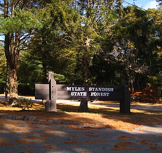
The greater Plymouth, Massachusetts area hosts some of the most significant natural ecosystems in the Northeastern United States. Outwash from the last of numerous glacial periods left thick glacial deposits of sand and gravel, providing the geologic foundation for globally rare pine barrens. This fire-adapted forest is home to a host of rare species found almost nowhere else in the world. Interspersed among the 20,000 acres (80 km²) of pine barrens are dozens of remarkable coastal plain ponds. In addition to supporting federally endangered Plymouth Redbelly Turtles and globally rare plant communities, these ponds are windows on the Plymouth/Carver Sole Source Aquifer - the largest drinking water aquifer in the state of Massachusetts.

Plymouth red-bellied turtle subspecies of reptile

The Plymouth red-bellied turtle, sometimes called the Plymouth red-bellied cooter, the first freshwater turtle in the US to be listed as endangered, by the United States Fish and Wildlife Service was found only in Plymouth County, Massachusetts before the state began trying to establish populations in other areas. Current thinking is that they are not a full subspecies and that they belong in synonymy under Pseudemys rubriventris or northern red-bellied cooter. Nevertheless, it is well recognized that the Plymouth red-bellied turtle extends the range of the northern red-bellied cooter by 30–40 percent. In 1983, Massasoit National Wildlife Refuge was established to help conserve the Plymouth red-bellied turtle.

Rachel Carson National Wildlife Refuge

The Rachel Carson National Wildlife Refuge is a 9,125-acre (37 km2) National Wildlife Refuge made up of several parcels of land along 50 miles (80 km) of Maine's southern coast. Created in 1966, it is named for environmentalist and author Rachel Carson, whose book Silent Spring raised public awareness of the effects of DDT on migratory songbirds, and of other environmental issues.

Halfway Pond a 232-acre (0.94 km2) warm water pond located in Plymouth, Massachusetts between Myles Standish State Forest and Long Pond, west of Round Pond, southwest of Gallows Pond, and north of Fawn Pond and White Island Pond. The average depth is nine feet and the maximum depth is 13 feet (4.0 m). The pond is fed by the outflow of Long Pond and drains into the Agawam River. Halfway Pond Island lies in the middle of the pond and is managed as a research natural area by The Nature Conservancy in Massachusetts. There are almost three miles (5 km) of shoreline.

Curlew Pond is a 43-acre (170,000 m2) natural warm water pond in Plymouth, Massachusetts, located in the Myles Standish State Forest.

Boot Pond is a 76-acre (310,000 m2) pond in Plymouth, Massachusetts within the Eel River watershed. The pond is located west of South Pond village, northwest of Gunners Exchange Pond and Hoyts Pond, and north of Myles Standish State Forest. The pond is a secondary municipal water supply for the Town of Plymouth.

Barrett Pond is a 16-acre (65,000 m2), warm water pond in the Myles Standish State Forest in Carver, Massachusetts, located less than ½ mile north of the forest headquarters, west of East Head Reservoir, and southwest of College Pond in Plymouth. The pond has an average depth of six feet and a maximum depth of 17 feet (5.2 m). Most of the shoreline is undeveloped except for a campground area on the eastern shore. Access is possible off Lower College Pond Road and is suitable only for car top boats or canoes, electric motors only.

Boggs Lake Ecological Reserve

The Boggs Lake Ecological Reserve is a nature reserve in Lake County, California. The land area is about one quarter of a square mile and contains a large vernal pool as well as endangered plants such as the Boggs Lake hedge-hyssop.

Black Bayou Lake National Wildlife Refuge

Black Bayou Lake National Wildlife Refuge is one of five refuges managed in the North Louisiana Refuge Complex and one of 545 refuges in the National Wildlife Refuge System. It was established in 1997 through a unique partnership with the city of Monroe, Louisiana. The U.S. Fish and Wildlife Service has a free 99-year lease to manage the city-owned lake.

Currituck National Wildlife Refuge

Currituck National Wildlife Refuge, located on the northern end of North Carolina's Outer Banks, was established in 1984 to preserve and protect the coastal barrier island ecosystem. Refuge lands are managed to provide wintering habitat for waterfowl and to protect endangered species such as piping plover, sea turtles, and seabeach amaranth.

Middle Atlantic coastal forests

The Middle Atlantic coastal forests are a temperate coniferous forest mixed with patches of evergreen broadleaved forests along the coast of the southeastern United States.

Southeastern conifer forests ecoregion in the United States

The Southeastern conifer forests are a tropical and subtropical coniferous forest ecoregion of the southeastern United States. It is the largest conifer forest ecoregion east of the Mississippi River.

References

  1. "Massasoit Area National Wildlife Refuge (Fws)". protectedplanet.net.

PD-icon.svg This article incorporates  public domain material from websites or documents ofthe United States Fish and Wildlife Service .

United States Fish and Wildlife Service US Federal Government agency

The United States Fish and Wildlife Service is an agency of the US Federal Government within the US Department of the Interior dedicated to the management of fish, wildlife, and natural habitats. The mission of the agency is "working with others to conserve, protect, and enhance fish, wildlife, plants and their habitats for the continuing benefit of the American people."