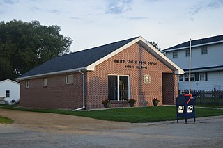
Jacksonport is a town in Jackson County, Arkansas, United States, along the White River at its confluence with the Black River. The population was 212 at the 2010 census.

Harmon is a village in Lee County, Illinois, United States. The population was 120 at the 2010 census, down from 149 in 2000.

Surprise is a village in southwestern Butler County, Nebraska, United States. The population was 43 at the 2010 census.

Palilula is one of five city municipalities which constitute the city of Niš. It has a population of 71,707 inhabitants. It was formed on 6 June 2002.

Tsilkar is a village in the Aragatsotn Province of Armenia.

Kamionka is a village in the administrative district of Gmina Księżpol, within Biłgoraj County, Lublin Voivodeship, in eastern Poland. It lies approximately 4 kilometres (2 mi) south of Księżpol, 17 km (11 mi) south of Biłgoraj, and 95 km (59 mi) south of the regional capital Lublin.

Miroszka is a village in the administrative district of Gmina Niechanowo, within Gniezno County, Greater Poland Voivodeship, in west-central Poland. It lies approximately 3 kilometres (2 mi) east of Niechanowo, 12 km (7 mi) south-east of Gniezno, and 56 km (35 mi) east of the regional capital Poznań. The village has a population of 100.

Jesionka is a village in the administrative district of Gmina Sompolno, within Konin County, Greater Poland Voivodeship, in west-central Poland. It lies approximately 12 kilometres (7 mi) south of Sompolno, 17 km (11 mi) north-east of Konin, and 106 km (66 mi) east of the regional capital Poznań.

Wróblewo is a village in the administrative district of Gmina Wronki, within Szamotuły County, Greater Poland Voivodeship, in west-central Poland. It lies approximately 7 kilometres (4 mi) south-west of Wronki, 21 km (13 mi) west of Szamotuły, and 51 km (32 mi) north-west of the regional capital Poznań.

Giełdon is a village in the administrative district of Gmina Brusy, within Chojnice County, Pomeranian Voivodeship, in northern Poland. It lies approximately 9 kilometres (6 mi) south of Brusy, 17 km (11 mi) north-east of Chojnice, and 86 km (53 mi) south-west of the regional capital Gdańsk.

Gniewowo is a village in the administrative district of Gmina Wejherowo, within Wejherowo County, Pomeranian Voivodeship, in northern Poland. It lies approximately 5 kilometres (3 mi) south-east of Wejherowo and 32 km (20 mi) north-west of the regional capital Gdańsk.

Karolewo is a village in the administrative district of Gmina Susz, within Iława County, Warmian-Masurian Voivodeship, in northern Poland. It lies approximately 2 kilometres (1 mi) west of Susz, 22 km (14 mi) north-west of Iława, and 79 km (49 mi) west of the regional capital Olsztyn.

Chlebowo is a village in the administrative district of Gmina Gryfino, within Gryfino County, West Pomeranian Voivodeship, in north-western Poland, close to the German border. It lies approximately 10 kilometres (6 mi) north-east of Gryfino and 12 km (7 mi) south of the regional capital Szczecin.
Parry is a hamlet in the Canadian province of Saskatchewan. Listed as a designated place by Statistics Canada, the hamlet had a population of 18 in the Canada 2006 Census.

Kaltungo is a Local Government Area of Gombe State, Nigeria. Its headquarters are in the town of Kaltungo in the west of the area on the A345 highway at 9°48′51″N11°18′32″E.

Poljanice is a village situated in Ljig municipality in Serbia.

Bela is a village in the municipality of Pirot, Serbia. According to the 2002 census, the village has a population of 37 people.

Obrenovac is a village in the municipality of Pirot, Serbia. According to the 2002 census, the village has a population of 143 people.

Miami Heights is a census-designated place (CDP) in Miami Township, Hamilton County, Ohio, United States. The population was 4,731 at the 2010 census.
Level Green is a census-designated place located in Penn Township, Westmoreland County in the state of Pennsylvania. The community is located near Pennsylvania Route 130. As of the 2010 census the population was 4,020 residents. It is the home of the legendary NASCAR veteran Norm Benning.


