
The Mendip Hills is a range of limestone hills to the south of Bristol and Bath in Somerset, England. Running east to west between Weston-super-Mare and Frome, the hills overlook the Somerset Levels to the south and the Chew Valley and other tributaries of the Avon to the north. The hills give their name to the local government district of Mendip, which administers most of the area. The higher, western part of the hills, covering 198 km2 (76 sq mi) has been designated an Area of Outstanding Natural Beauty (AONB), which gives it a level of protection comparable to a national park.
Charterhouse may refer to:
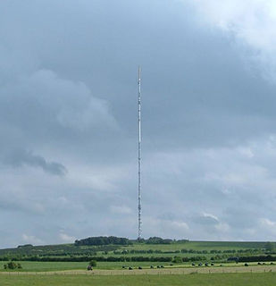
The Mendip transmitting station is a broadcasting and telecommunications facility, situated on the summit of Pen Hill, part of the Mendip Hills range in Somerset, England, at 305 metres (1,001 ft) above sea level. The station is located in St Cuthbert Out civil parish in Mendip district, approximately 2 miles (3.2 km) from the centre of Wells. It includes a 281.6 metres (924 ft) tall mast, which was built in 1967 and weighs around 500 tonnes, and is the tallest structure in South West England. The mast broadcasts digital television, FM analogue radio and DAB digital radio, and had broadcast analogue colour television from 1967 until 2010.

Pen Hill forms part of the Mendip Hills plateau in Somerset, England. The hill is located in St Cuthbert Out civil parish in Mendip district.

Chewton Mendip is a village and civil parish in the Mendip district of Somerset, England. It is situated 4 miles (6 km) north of Wells, 16 miles (26 km) south of Bristol on the Mendip Hills and is the source of the River Chew. The parish includes the hamlets of Bathway and Green Ore.

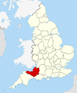
Somerton and Frome is a constituency represented in the House of Commons of the UK Parliament since 2015 by David Warburton of the Conservative Party.
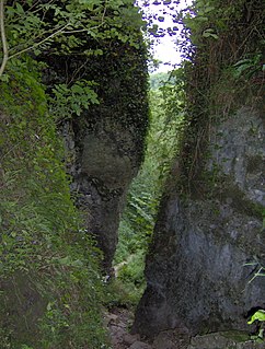
Ebbor Gorge is a limestone gorge in Somerset, England, designated and notified in 1952 as a 63.5-hectare (157-acre) biological Site of Special Scientific Interest in the Mendip Hills. It was donated to the National Trust in 1967 and is now managed by Natural England as a National Nature Reserve.
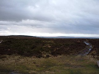
Black Down is the highest hill in the Mendip Hills, Somerset, in south-western England. Black Down lies just a few miles eastward of the Bristol Channel at Weston-super-Mare, and provides a view over the Chew Valley. The summit is marked with an Ordnance Survey trig point, the base of which has been rebuilt by the Mendip Hills AONB authority.

Priddy is a village in Somerset, England in the Mendip Hills, close to East Harptree and 5 miles (8 km) north-west of Wells. It is in the local government district of Mendip.

Charterhouse, also known as Charterhouse-on-Mendip, is a hamlet in the Mendip Hills Area of Outstanding Natural Beauty (AONB) in the English county of Somerset. The area between Charterhouse and Cheddar Gorge including Velvet Bottom and Ubley Warren is covered by the Cheddar Complex Site of Special Scientific Interest.
GB Cave is a cave between Charterhouse and Shipham in the limestone of the Mendip Hills, in Somerset, England, and is close to Charterhouse Cave, the deepest in the region.

Sidcot Swallet is a cave near Burrington Combe, in the Carboniferous Limestone of the Mendip Hills, in Somerset, England.
The Mendip Way is an 80-kilometre (50 mi) long-distance footpath across the Mendip Hills from Weston-super-Mare to Frome. It is divided into two sections.

The Mells River flows through the eastern Mendip Hills in Somerset, England. It rises at Gurney Slade and flows east joining the River Frome at Frome.
The county of Somerset is in South West England, bordered by the Bristol Channel and the counties of Bristol and Gloucestershire to the north, and Wiltshire to the east, Dorset to the south, and Devon to the west. The climate, influenced by its proximity to the Atlantic Ocean and the prevailing westerly winds, tends to be mild, damp and windy.

Leigh-on-Mendip or Leigh upon Mendip is a small village on the Mendip Hills in Somerset, England. It lies roughly equidistant from Frome, Radstock and Shepton Mallet at about 5 miles (8 km) from each town.

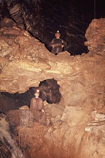
Manor Farm Swallet is a cave in the limestone of the Mendip Hills, in Somerset, England which was subject to numerous failed digging attempts between 1947 and 1973 as the surface shafts kept collapsing.
In 1973 access to the cave was gained by an artificial shaft and walling it against collapse.

There are over 670 scheduled monuments in the ceremonial county of Somerset in South West England. The county consists of a non-metropolitan county, administered by Somerset County Council, which is divided into five districts, and two unitary authorities. The districts of Somerset are West Somerset, South Somerset, Taunton Deane, Mendip and Sedgemoor. The two administratively independent unitary authorities, which were established on 1 April 1996 following the breakup of the county of Avon, are North Somerset and Bath and North East Somerset. These unitary authorities include areas that were once part of Somerset before the creation of Avon in 1974.
Picken's Hole is a small cave on the southern side of Crook Peak in the Mendip Hills in the English county of Somerset. It has been designated as a scheduled monument. It has sometimes been confused with a nearby cave called Scragg's Hole, including by the Somerset Historic Environment Record.

