Meningie, South Australia

Last updated

Meningie
South Australia
MeningieHotel.JPG
Meningie Hotel
Australia South Australia location map.svg
Red pog.svg
Meningie
Coordinates 35°41′18″S139°20′16″E / 35.68833°S 139.33778°E / -35.68833; 139.33778 Coordinates: 35°41′18″S139°20′16″E / 35.68833°S 139.33778°E / -35.68833; 139.33778 [1]
Population
Established1866 (town)
2000 (locality) [4] [5]
Postcode(s) 5264 [6]
Elevation3 m (10 ft) [7]
Time zone ACST (UTC+9:30)
 • Summer (DST) ACST (UTC+10:30)
Location
LGA(s) The Coorong District Council [1]
Region Murray and Mallee [1]
County Russell [1]
State electorate(s) Mackillop [8]
Federal division(s) Barker [9]
Mean max temp [7] Mean min temp [7] Annual rainfall [7]
21.1 °C
70 °F
10.5 °C
51 °F
463.9 mm
18.3 in
Localities around Meningie:
Lake Albert Waltowa Meningie East
Lake Albert
Meningie West
Meningie Meningie East
Field
Coorong Coorong Field
Coorong
FootnotesLocation [6] [1]
Adjoining localities [1]

Meningie is a town on the south-east side of Lake Albert in South Australia. It is on the Princes Highway near The Coorong and was surveyed in 1866. [10] At the 2016 census, the locality of Meningie had a population of 1118 with a median age of 51 while its town centre had a population of 852. [2] [3]

Contents

History

The word Meningie is derived from "the Aboriginal word 'meningeng' meaning 'place of mud'". [4]

The town was surveyed between March and June 1866 by W. Farquhar without any proclamation. Land was offered for sale on 23 August 1866. [4] The name also was used for an "adjoining private subdivision of sections 104, 106/9 and 111" in the cadastral unit of the Hundred of Bonney. [1]

A school was opened in 1869. A jetty was erected in 1867, with paddle steamers operating between Meningie and other ports on Lake Albert and Lake Alexandrina until 1927/1928. The town ceased to operate as a port in December 1936. [4]

Boundaries for the locality were created for the "long established name" on 24 August 2000 and which include the Government Town of Meningie. [5]

Meningie was the first place in Australia to have ADSL broadband installed without using a Telstra DSLAM. Agile Communications installed their own DSLAM in Meningie in October 2003, following on from having established a microwave network connecting to Adelaide in May 2001. Agile's associated internet service provider, Internode Systems offered services through this DSLAM. [11]

Climate

Meningie experiences a warm-summer mediterranean climate, bordering on a cold semi-arid climate (Köppen climate classification: Csb/BSk), Trewartha: Csbl/BSbl); with warm, dry summers; mild, relatively dry springs and autumns; and mild winters with moderate precipitation.

Climate data for Meningie, South Australia, Australia (1991-2020 normals, extremes 1864-present); 3 m AMSL
MonthJanFebMarAprMayJunJulAugSepOctNovDecYear
Record high °C (°F)46.1
(115.0)
44.2
(111.6)
40.8
(105.4)
35.3
(95.5)
29.2
(84.6)
25.3
(77.5)
23.6
(74.5)
25.5
(77.9)
30.7
(87.3)
36.4
(97.5)
41.1
(106.0)
42.3
(108.1)
46.1
(115.0)
Mean maximum °C (°F)36.0
(96.8)
35.2
(95.4)
32.4
(90.3)
28.3
(82.9)
22.0
(71.6)
17.8
(64.0)
17.2
(63.0)
19.5
(67.1)
23.4
(74.1)
27.4
(81.3)
31.7
(89.1)
33.5
(92.3)
36.0
(96.8)
Average high °C (°F)26.6
(79.9)
26.4
(79.5)
24.6
(76.3)
21.9
(71.4)
18.3
(64.9)
15.8
(60.4)
15.1
(59.2)
16.2
(61.2)
18.5
(65.3)
21.1
(70.0)
23.6
(74.5)
25.0
(77.0)
21.1
(70.0)
Daily mean °C (°F)20.6
(69.1)
20.4
(68.7)
18.7
(65.7)
16.3
(61.3)
13.7
(56.7)
11.5
(52.7)
11.1
(52.0)
11.7
(53.1)
13.6
(56.5)
15.5
(59.9)
17.6
(63.7)
19.1
(66.4)
15.8
(60.5)
Average low °C (°F)14.5
(58.1)
14.3
(57.7)
12.7
(54.9)
10.7
(51.3)
9.0
(48.2)
7.2
(45.0)
7.0
(44.6)
7.2
(45.0)
8.6
(47.5)
9.9
(49.8)
11.6
(52.9)
13.2
(55.8)
10.5
(50.9)
Mean minimum °C (°F)9.9
(49.8)
9.5
(49.1)
7.8
(46.0)
6.0
(42.8)
4.2
(39.6)
2.6
(36.7)
3.0
(37.4)
3.2
(37.8)
4.0
(39.2)
5.0
(41.0)
6.7
(44.1)
8.5
(47.3)
2.6
(36.7)
Record low °C (°F)4.0
(39.2)
4.7
(40.5)
3.4
(38.1)
0.6
(33.1)
−0.4
(31.3)
−3.3
(26.1)
−2.5
(27.5)
−0.9
(30.4)
−0.1
(31.8)
−0.1
(31.8)
2.5
(36.5)
4.0
(39.2)
−3.3
(26.1)
Average precipitation mm (inches)18.6
(0.73)
18.7
(0.74)
17.1
(0.67)
33.5
(1.32)
53.0
(2.09)
62.5
(2.46)
64.6
(2.54)
58.3
(2.30)
50.2
(1.98)
34.6
(1.36)
26.5
(1.04)
26.3
(1.04)
463.9
(18.27)
Average precipitation days (≥ 1.0 mm)3.22.83.65.99.511.011.711.39.66.15.14.284
Average relative humidity (%)60.061.565.066.574.579.578.572.569.062.561.060.067.5
Average dew point °C (°F)13.0
(55.4)
13.3
(55.9)
12.4
(54.3)
11.2
(52.2)
10.2
(50.4)
9.1
(48.4)
8.3
(46.9)
8.0
(46.4)
9.2
(48.6)
9.6
(49.3)
10.9
(51.6)
12.0
(53.6)
10.6
(51.1)
Source 1: Australian Bureau of Meteorology (1991-2020 normals) [12]
Source 2: Australian Bureau of Meteorology (1864-present extremes) [13]

Tourism

Meningie Cheese Factory Museum Inc Meningie Cheese Factory Museum Inc.jpg
Meningie Cheese Factory Museum Inc

Meningie has attractions and amenities for travellers and is the closest township to the Coorong National Park. The Lake provides visitors with many scenic locations and places to fish, swim, kayak, jet ski and water ski / wake-board. Bird watchers also enjoy coming to see the range of rare and vulnerable wildlife that the Lake and wetlands support. There are local 4WD tracks, bush walking trails, and indigenous cultural journeys at Camp Coorong. The Meningie Cheese Factory Museum Inc. is wholly owned and operated by volunteers, and is both educational and a tourist attraction for the town. It is alongside the Cheese Factory Restaurant and the Lake Albert Caravan Park which is directly opposite.

In May 2013, a statue of an ostrich wearing a saddle was unveiled to commemorate the story of a local Irish bushranger, John Francis Peggotty, also known as "Birdman of the Coorong". [14] [15]

Media

Meningie is home to The Lakelander, a regional community newspaper [16] whose geographical coverage includes Tailem Bend, Salt Creek, Narrung, Coonalpyn and Tintinara. [17] The newspaper, first issued on 25 June 1976, is published in a magazine format. [18]

Sports

Meningie Post Office MeningiePostOffice.JPG
Meningie Post Office

Meningie has a strong sporting culture, and has a well maintained oval, a fully watered, par 72, 18-hole golf course, [19] bike tracks/ motocross jumps, sailing club, and also an airstrip for gliders, light aircraft and balloons.

Meningie has a local Australian rules football club, founded around 1890, [20] known as the Meningie Bears. On 12 December 2007, Meningie player Brodie Martin was rookie listed to Australian Football League (AFL) club Adelaide, becoming the first player from Meningie to be play for an AFL club. As of 2020 the league coach is Alex Scott.

Other sporting clubs in Meningie include the Meningie Motorcycle Club, Lake Albert Golf Club, Meningie Sailing Club, Meningie Bowling Club, Meningie Pony Club, Meningie Netball Club, Meningie Aero Club and Lake Albert Gun Club. There is also a Meningie Garden Club, Meningie & Districts Lions Club, and several church groups that meet regularly.

Governance

Meningie is located within the federal division of Barker, the state electoral district of MacKillop, and the local government area of the Coorong District Council. [9] [1] [8]

Related Research Articles

Internode (ISP)

Internode Pty Ltd is an Australian Internet service provider (ISP) that provides NBN broadband services, business-class broadband access, web hosting, co-location, Voice over IP, and a variety of related services. Internode became part of the TPG Telecom group in July, 2020

Agile Communications is a licensed national telecommunications carrier based in South Australia and was the first South Australian based company to gain this license. The company is the wholesale subsidiary of ISP Internode. The company was founded by Internode Managing Director Simon Hackett and Catherine Conway and is based in Adelaide. Internode and Agile were bought out by iiNet in 2012 and iiNet itself was acquired by TPG Telecom in 2015.

Lake Albert (South Australia) Lake in South Australia

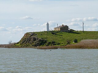
Lake Albert, also known by its Ngarrindjeri name, Yarli, is a notionally fresh water lake near the mouth of the Murray River in South Australia. It is filled by water flowing in from the larger Lake Alexandrina at its mouth near Narrung. It is separated on the south by the Narrung Peninsula from the salt-water Coorong. The only major town on the lake is Meningie. Lakes Alexandrina and Albert are together known as the Lower Lakes.

Jabuk, South Australia Town in South Australia

Jabuk is a locality in the Australian state of South Australia located about 142 kilometres (88 mi) south-east of the state capital of Adelaide and respectively about 78 kilometres (48 mi) west and 58 kilometres (36 mi) east of the municipal seats of Pinnaroo and Tailem Bend.

Coonalpyn, South Australia Town in South Australia

Coonalpyn is a town and a locality in the Australian state of South Australia located about 143 kilometres (89 mi) south-east of the state capital of Adelaide and about 61 kilometres (38 mi) south-east of the municipal seat in Tailem Bend. It is situated in the local government area of the Coorong District Council and is in the State electoratal district of MacKillop and the Federal division of Barker.

Coorong, South Australia Suburb of Coorong, Kingston, (north to south), South Australia

Coorong is a locality in the Australian state of South Australia which is associated with the lagoon known as the Coorong in the south-east of the state and which overlooks the continental coastline from the mouth of the Murray River about 80 kilometres south-east of the state capital of Adelaide to the immediate north of the town of Kingston SE extending for a distance of at least 140 kilometres (87 mi).

Peake, South Australia Town in South Australia

Peake is a town and locality in the Australian state of South Australia situated along the Mallee Highway (B12), approximately 150 kilometres (93 mi) east of the state capital of Adelaide.

Yumali, South Australia Town in South Australia

Yumali is a very small country town in South Australia 162 km southeast of Adelaide on the Dukes Highway (A8). Yumali belongs to The Coorong District Council and is in the State electorate of Hammond and the Federal electorate of Barker. Yumali is in the County of Buccleuch.

Coorong District Council Local government area in South Australia

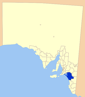
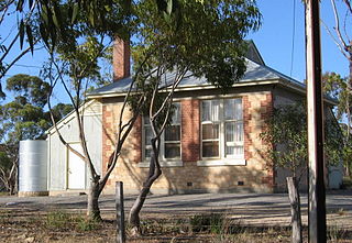
Coorong District Council is a local government area in South Australia located between the River Murray and the Limestone Coast region. The district cover mostly rural areas with small townships, as well as part of the Coorong National Park.

Culburra is a town and locality in the Australian state of South Australia. It is located on the Dukes Highway and Melbourne–Adelaide railway. , about 158 kilometres (98 mi) south-east of the state capital of Adelaide and about 77 kilometres (48 mi) south-east of the municipal seat of Tailem Bend.

Murraylands Geographic region in the eastern part of South Australia

The Murraylands is a geographical region of the Australian state of South Australia (SA); its name reflects that of the river running through it. Lying due east of South Australia's capital city, Adelaide, it extends from the eastern slopes of the Mount Lofty Ranges to the border with the state of Victoria, a distance of about 180 kilometres. The north-to-south distance is about 130 kilometres. The region's economy is centred on agriculture, and tourism, especially along its 200-kilometre (120-mile) frontage of the River Murray.

Salt Creek, South Australia Town in South Australia

Salt Creek is a small settlement in South Australia, located along the Coorong, and is also the location of the Coorong National Park Information Centre.

Ngarkat, South Australia Unpopulated region of South Australia

Ngarkat is a locality in the Australian state of South Australia located in the south-east of the state at the border with the state of Victoria in both the Murray Mallee and the Limestone Coast regions about 227 kilometres south east of the state capital of Adelaide.

Goolwa South Suburb of Alexandrina Council, South Australia

Goolwa South is a locality in the Australian state of South Australia located about 67 kilometres south of the state capital of Adelaide on both on the southern continental coastline and the south-western coast of Lake Alexandrina. It occupies the full extent of the Sir Richard Peninsula, land to the immediate west and part of the Goolwa Channel in the lake system to its north.

Poltalloch, South Australia Suburb of Coorong District Council, South Australia

Poltalloch is a locality in the Australian state of South Australia located on land between the water bodies of Lake Alexandrina and Lake Albert about 87 kilometres south-east of the state capital of Adelaide.

Tolderol is a locality in the Australian state of South Australia located about 67 kilometres south of the Adelaide city centre, 32 kilometres north-east of the centre of Goolwa and 32 kilometres south-west of the centre of Murray Bridge on the west coastline of Lake Alexandrina.

Field is a locality in the Australian state of South Australia located in the state’s south-east about 139 kilometres (86 mi) south-east of the state capital of Adelaide and about 61 kilometres (38 mi) south-east of the municipal seat in Tailem Bend.

Meningie West is a locality in the Australian state of South Australia located in the state’s south-east about 99 kilometres (62 mi) south-east of the state capital of Adelaide and about 50 kilometres (31 mi) south-west of the municipal seat in Tailem Bend.

Meningie East is a locality in the Australian state of South Australia located about 120 kilometres (75 mi) south-east of the state capital of Adelaide and about 43 kilometres (27 mi) south-east of the municipal seat in Tailem Bend.

John Francis Peggotty was an Irish bushranger in Australia also known as the "Birdman of the Coorong". He reputedly rode an ostrich and wore large amounts of gold jewellery while committing his crimes, though some claim that the story is a fabrication.

References

  1. 1 2 3 4 5 6 7 8 "Search result for 'Meningie, Locb' with the following datasets selected - 'Suburbs and Localities', 'Government Towns', 'Counties', 'Hundreds', 'Local Government Areas', 'SA Government Regions' and 'Gazetteer'". Location SA Map viewer. Government of South Australia. Retrieved 9 April 2019.
  2. 1 2 Australian Bureau of Statistics (27 June 2017). "Meningie (UCL)". 2016 Census QuickStats. Retrieved 6 January 2018. OOjs UI icon edit-ltr-progressive.svg
  3. 1 2 Australian Bureau of Statistics (27 June 2017). "Meningie (SSC)". 2016 Census QuickStats. Retrieved 6 January 2018. OOjs UI icon edit-ltr-progressive.svg
  4. 1 2 3 4 Manning, Geoffrey. "South Australian Names - M" (PDF). Manning Index of South Australian History. State Library of South Australia. Retrieved 6 January 2018.
  5. 1 2 "GEOGRAPHICAL NAMES ACT 1991, Notice to Assign Boundaries and Names to Places" (PDF), The South Australian Government Gazette: 596, 24 August 2000, retrieved 5 January 2018
  6. 1 2 "Postcode for Meningie, South Australia". Postcodes Australia. Retrieved 6 January 2018.
  7. 1 2 3 4 "Monthly climate statistics: Summary statistics Summary statistics MENINGIE (nearest weather station)". Commonwealth of Australia , Bureau of Meteorology. Retrieved 5 January 2018.
  8. 1 2 "District of Mackillop profile". Electoral Commission SA. Retrieved 9 April 2019.
  9. 1 2 "Federal electoral division of Barker" (PDF). Australian Electoral Commission. Retrieved 28 December 2017.
  10. "Meningie, South Australia". Placenames Online. Government of South Australia. Archived from the original on 30 September 2007. Retrieved 19 June 2006.
  11. Simon Wright (3 October 2003). "Internode launches own ADSL network". Whirlpool . Retrieved 19 June 2006.
  12. "Meningie, SA Climate (1991-2020 normals)". Australian Bureau of Meteorology . Retrieved 5 June 2022.
  13. "Meningie, SA Climate (1864-present extremes)". Australian Bureau of Meteorology . Retrieved 5 June 2022.
  14. "Liam Peggotty -The Irish ostrich-riding bandit who terrorised Adelaide". Ireland's Own. Retrieved 24 August 2021.
  15. "The Bold, The Bad and The Ugly: 'Australia's Wild Colonial Bushrangers'". ramint.gov.au. Royal Australian Mint. 11 January 2019. Retrieved 24 August 2021.
  16. "Meningie Community Website - The Lakelander". meningie.com.au. Retrieved 17 August 2018.
  17. Laube, Anthony. "LibGuides: SA Newspapers: F-L". guides.slsa.sa.gov.au. Retrieved 17 August 2018.
  18. "Lakelander" . Retrieved 17 August 2018.
  19. "History".
  20. "Meningie". South Australian Chronicle (Adelaide, SA : 1889 - 1895) . Adelaide, SA: National Library of Australia. 14 June 1890. p. 12. Retrieved 10 September 2013.