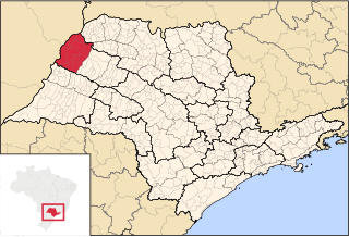
Microregion of Votuporanga

Last updated
Microregion of
Votuporanga
Microregion
SaoPaulo Micro Votuporanga.svg
Location of the Microregion of Votuporanga
Coordinates: 20°25′02″S49°58′22″W / 20.41722°S 49.97278°W / -20.41722; -49.97278 Coordinates: 20°25′02″S49°58′22″W / 20.41722°S 49.97278°W / -20.41722; -49.97278
Country Flag of Brazil.svg  Brazil
Region Southeast
State Bandeira do Estado de Sao Paulo.svg  São Paulo
Mesoregion São José do Rio Preto
Area
  Total 3,208.7 km2 (1,238.9 sq mi)
Population (2010/IBGE)
  Total 166,057
  Density 52/km2 (130/sq mi)
Time zone UTC-3 (UTC-3)
  Summer (DST) UTC-2 (UTC-2)
Postal Code15500-000
Area code(s) +55 17

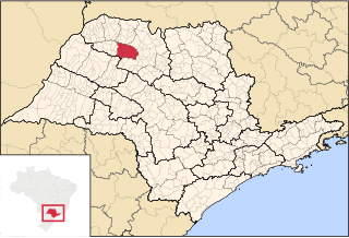
The Microregion of Votuporanga (Portuguese : Microrregião de Votuporanga) is located on the northwest of São Paulo state, Brazil, and is made up of 9 municipalities. It belongs to the Mesoregion of São José do Rio Preto.
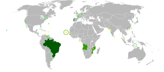
Portuguese language Romance language that originated in Portugal

Portuguese is a Western Romance language originating in the Iberian Peninsula. It is the sole official language of Portugal, Brazil, Cape Verde, Guinea-Bissau, Mozambique, Angola, and São Tomé and Príncipe. It also has co-official language status in East Timor, Equatorial Guinea and Macau in China. As the result of expansion during colonial times, a cultural presence of Portuguese and Portuguese creole speakers are also found in Goa, Daman and Diu in India; in Batticaloa on the east coast of Sri Lanka; in the Indonesian island of Flores; in the Malacca state of Malaysia; and the ABC islands in the Caribbean where Papiamento is spoken, while Cape Verdean Creole is the most widely spoken Portuguese-based Creole. Reintegrationists maintain that Galician is not a separate language, but a dialect of Portuguese. A Portuguese-speaking person or nation is referred to as "Lusophone" (Lusófono).

São Paulo (state) State of Brazil

São Paulo is one of the 26 states of the Federative Republic of Brazil and is named after Saint Paul of Tarsus. As the richest Brazilian state and a major industrial complex, often dubbed the "locomotive of Brazil", the state is responsible for 33.9% of the Brazilian GDP. São Paulo also has the second highest Human Development Index (HDI) and GDP per capita, the fourth lowest infant mortality rate, the third highest life expectancy, and the third lowest rate of illiteracy among the federative units of Brazil, being by far, the safest state in the country. The homicide rate is 3.8 per 100 thousand as of 2018, almost 1/4 of the Brazilian rate. São Paulo alone is richer than Argentina, Uruguay, Paraguay and Bolivia combined. If São Paulo were an independent country, its nominal GDP would be ranked among the top 20 in the world. The economy of São Paulo State is the most developed in Brazil.
Brazil Federal republic in South America

Brazil, officially the Federative Republic of Brazil, is the largest country in both South America and Latin America. At 8.5 million square kilometers and with over 208 million people, Brazil is the world's fifth-largest country by area and the fifth most populous. Its capital is Brasília, and its most populated city is São Paulo. The federation is composed of the union of the 26 states, the Federal District, and the 5,570 municipalities. It is the largest country to have Portuguese as an official language and the only one in the Americas; it is also one of the most multicultural and ethnically diverse nations, due to over a century of mass immigration from around the world.

The microregion has a population of 139,475 inhabitants, in an area of 3,208.7 km² [1]

Municipalities

The microregion consists of the following municipalities, [2] listed below with their 2010 Census populations (IBGE/2010): [3]

Brazilian Institute of Geography and Statistics Brazils principal government institution in charge of statistics and census data

The Brazilian Institute of Geography and Statistics or IBGE is the agency responsible for official collection of statistical, geographic, cartographic, geodetic and environmental information in Brazil. IBGE performs a decennial national census; questionnaires account for information such as age, household income, literacy, education, occupation and hygiene levels.

Álvares Florence Municipality in Southeast, Brazil

Álvares Florence is a municipality in the state of São Paulo, Brazil. It has a population of 3,897 inhabitants (IBGE/2010) and an area of 362.9 km².

Américo de Campos Municipality in Southeast, Brazil

Américo de Campos is a Brazilian municipality of the state of São Paulo. The population is 5,942 in an area of 252.9 km2 (97.6 sq mi).

Cardoso, São Paulo Municipality in Southeast, Brazil

Cardoso is a municipality in the state of São Paulo, Brazil. The city has a population of 12,281 inhabitants and an area of 639.7 km².

Related Research Articles

Araçatuba Place in Southeast, Brazil

Araçatuba is a city located in the northwest of São Paulo state, Brazil. The city has 190,536 inhabitants (IBGE/2013) and 1,167.4 km² of area. The city name comes from the Tupi language and means "abundance of araçá ". Araçatuba is located 532 km from the city of São Paulo and 11 km from Birigui.

Fernandópolis Municipality in Southeast, Brazil

Fernandópolis is a municipality in the state of São Paulo, Brazil. The population is 68,670(2017 est.) in an area of 554;km². Fernandópolis is the center of the microregion of Fernandópolis with 104,623 inhabitants and area of 2,811.7 km².

José Bonifácio, São Paulo Municipality in Southeast, Brazil

José Bonifácio is a municipality in the state of São Paulo, Brazil. The population is of 32,763 inhabitants and the area is 859.94 km². The city belongs to the Microregion of São José do Rio Preto.

Nova Granada Municipality in Southeast, Brazil

Nova Granada is a municipality in the northern part of the state of São Paulo, Brazil. The population is 19,180 inhabitants (IBGE/2010), and the area is 533.49 km². The elevation is 542 m.

Olímpia Municipality in Southeast, Brazil

Olímpia is a municipality in the northern part of the state of São Paulo, Brazil. The population, measured in 2010 by the IBGE, is 50,024 inhabitants. The city has an area of 802.6 km2 (309.9 sq mi).

Potirendaba Municipality in Southeast, Brazil

Potirendaba is a municipality in the state of São Paulo, Brazil. The city has 15,449 inhabitants (IBGE/2010) and an area of 342.4 km².

Votuporanga Municipality in Southeast, Brazil

Votuporanga is a municipality in the Northwest of the São Paulo state, Brazil. The city is located 520 km from São Paulo. The population of the city, according to the IBGE, is 104,692 inhabitants. Votuporanga is the center of a Microregion with 159,475 inhabitants. In 2018, the Roman Catholic Diocese of Votuporanga was formed by Pope Francis.

Microregion of São José do Rio Preto Microregion in Southeast, Brazil

The Microregion of São José do Rio Preto is located on the north of São Paulo state, Brazil, and is made up of 29 municipalities. It belongs to the Mesoregion of São José do Rio Preto.

Microregion of Novo Horizonte Microregion in Southeast, Brazil

The Microregion of Novo Horizonte is located on the north of São Paulo state, Brazil, and is made up of 6 municipalities. It belongs to the Mesoregion of São José do Rio Preto.

Microregion of Catanduva Microregion in Southeast, Brazil

The Microregion of Catanduva is located on the north of São Paulo state, Brazil, and is made up of 13 municipalities. It belongs to the Mesoregion of São José do Rio Preto.

Microregion of Auriflama Microregion in Southeast, Brazil

The Microregion of Auriflama is located on the northwest of São Paulo state, Brazil, and is made up of 9 municipalities. It belongs to the Mesoregion of São José do Rio Preto.

Microregion of Jales Microregion in Southeast, Brazil

The Microregion of Jales is located on the northwest of São Paulo state, Brazil, and is made up of 23 municipalities. It belongs to the Mesoregion of São José do Rio Preto.

Microregion of Fernandópolis Microregion in Southeast, Brazil

The Microregion of Fernandópolis is located on the northwest of São Paulo state, Brazil, and is made up of 13 municipalities. It belongs to the Mesoregion of São José do Rio Preto.

Microregion of Nhandeara Microregion in Southeast, Brazil

The Microregion of Nhandeara is located on the northwest of São Paulo state, Brazil, and is made up of 9 municipalities. It belongs to the Mesoregion of São José do Rio Preto.

Microregion of São Carlos Microregion in Southeast, Brazil

The Microregion of São Carlos is located on the east-center of São Paulo state, Brazil, and is made up of 6 municipalities. It belongs to the Mesoregion of Araraquara.

Microregion of Araçatuba Microregion in Southeast, Brazil

The Microregion of Araçatuba is located on the northwest of São Paulo state, Brazil, and is made up of 7 municipalities. It belongs to the Mesoregion of Araçatuba.

Microregion of Birigüi Microregion in Southeast, Brazil

The Microregion of Birigüi is located on the northwest of São Paulo state, Brazil, and is made up of 18 municipalities. It belongs to the Mesoregion of Araçatuba.

Microregion of Andradina Microregion in Southeast, Brazil

The Microregion of Andradina is located on the northwest of São Paulo state, Brazil, and is made up of 11 municipalities. It belongs to the Mesoregion of Araçatuba.

Microregion of Assis Microregion in Southeast, Brazil

The Microregion of Assis is located on the west of São Paulo state, Brazil, and is made up of 17 municipalities and it belongs to the Mesoregion of Assis.

References

  1. "2010 Census of the IBGE - Synopsis - Tables 761 and 1301" (in Portuguese). IBGE.gov.br. Retrieved 13 July 2011.
  2. Instituto Brasileiro de Geografia e Estatística [ permanent dead link ], territorial division.
  3. "2010 Census of the IBGE - Population - Table 2.1.20" (PDF). IBGE.gov.br. Retrieved 13 July 2011.