This page is based on this
Wikipedia article Text is available under the
CC BY-SA 4.0 license; additional terms may apply.
Images, videos and audio are available under their respective licenses.
Since 1970, the South Australian House of Assembly has consisted of 47 single-member electoral districts consisting of approximately the same number of enrolled voters. The district boundaries are regulated by the State Electoral Office, according to the requirements of the South Australian Constitution and are subject to mandatory redistributions by the State Electoral Office in order to respond to changing demographics.

Chaffey, created in 1936, is a single-member electoral district for the South Australian House of Assembly. It covers the Riverland region of South Australia including the towns of Renmark, Berri, Barmera, Loxton and Waikerie. The seat is named after brothers George and William Chaffey who established the irrigation area along the Murray River from 1886.

Mount Gambier is a single-member electoral district for the South Australian House of Assembly. It covers the far south-east corner of the state containing the City of Mount Gambier and District Council of Grant local government areas. It is centred on the city and extinct volcano of Mount Gambier.
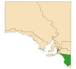
MacKillop is a single-member electoral district for the South Australian House of Assembly. It was named in 1991 after Sister Mary MacKillop who served the local area, and later became the first Australian to be canonised as a Roman Catholic saint. MacKillop is a 25,313 km² rural electorate in the south-east of the state, stretching south and west from the mouth of the Murray River to the Victorian State border, but excluding the far-southern point of the state,. It contains the Kingston District Council, Naracoorte Lucindale Council, District Council of Robe, Tatiara District Council, Wattle Range Council, as well as parts of The Coorong District Council. The main population centres are Bordertown, Keith, Kingston SE, Meningie, Millicent, Naracoorte, Penola and Robe.

Thornlea is a locality in the Australian state of South Australia located in the state's south-east within the Limestone Coast region about 309 kilometres (192 mi) south east of the state capital of Adelaide and about 25 kilometres (16 mi) north-west of the municipal seat of Millicent.

The 1968 South Australian State election was held in South Australia on 2 March 1968. All 39 seats in the South Australian House of Assembly were up for election; 38 of the 39 contests were won by candidates from Australia's two major political parties. The incumbent Australian Labor Party and the Liberal and Country League both won 19 seats. The sole independent candidate to win a race, Tom Stott of the Ridley electorate, joined with the LCL's 19 seats to form a coalition government that held a 20 to 19 majority, thus defeating the Dunstan ALP government.
The Mid South Eastern Football League is an Australian rules football competition based in the Limestone Coast region of South Australia. It is an affiliated member of the South Australian National Football League.

Rendelsham is a town in the south-east of South Australia, 392 kilometres (244 mi) south east of the state capital, Adelaide. It is on the Southern Ports Highway between Beachport and Millicent.
Victoria was an electorate in the South Australian House of Assembly from 1857 until 1902 and from 1915 to 1993.
Victoria and Albert was an electoral district in the South Australian House of Assembly from 1902 to 1915. The seat elected candidates of both major parties at various times. It merged the seats of Victoria and Albert, which were both recreated on its abolition.

Canunda is a locality in the Australian state of South Australia located on the state’s south-east coast overlooking the body of water known in Australia as the Southern Ocean and by international authorities as the Great Australian Bight. It is about 339 kilometres south-east of the state capital of Adelaide and 49 kilometres south of the centre of Mount Gambier.

Bool Lagoon is a locality in the Australian state of South Australia located in the south-east of the state in the Limestone Coast region about 311 kilometres south east of the state capital of Adelaide.
Clay Wells is a locality in the Australian state of South Australia located in the state's south-east within the Limestone Coast region about 300 kilometres (190 mi) south east of the state capital of Adelaide, and about 39 kilometres (24 mi) south-east and about 35 kilometres (22 mi) north-west respectively of the municipal seats of Robe and Millicent.
Kangaroo Inn is a locality in the Australian state of South Australia located in the state's south-east within the Limestone Coast region about 306 kilometres (190 mi) south-east of the state capital of Adelaide, and about 30 kilometres (19 mi) south-east and about 46 kilometres (29 mi) north-west respectively of the municipal seats of Robe and Millicent.
Mount McIntyre is a locality in the Australian state of South Australia located in the state’s south-east about 388 kilometres (241 mi) south-east of the state capital of Adelaide and about 16 kilometres (9.9 mi) east of the municipal seat in Millicent.
Magarey is a locality in the Australian state of South Australia located in the state’s south-east about 307 kilometres (191 mi) south-east of the state capital of Adelaide and about 35 kilometres (22 mi) west of the municipal seat in Millicent.
Wattle Range is a locality in the Australian state of South Australia located in the state’s south-east about 328 kilometres (204 mi) south-east of the state capital of Adelaide and about 25 kilometres (16 mi) north-east of the municipal seat in Millicent.
The District Council of Millicent was a local government area in South Australia seated at Millicent.

