Missisquoi County, part of the Eastern Townships (one of roughly 12 regions in Québec), is located on the western fringes of the Appalachian foothills, giving it a rolling landscape on its eastern part. The western part of the county is situated on the Richelieu River plains.
Missisquoi County is bound entirely on the south for 51km by the Canada–US border (45° N) from 72°40.5' W to the middle of the Richelieu River (73°20.8' W), to the east by Brome County for 23km along the meridian defined by 72°40.5' W, to the northeast by Brome County and the northwest by Rouville County, and to the west by Iberville County and the Richelieu River (Saint-Jean County is on the other side of the river). The northernmost point of the county is at 45°21' N and 73° W and is also the junction of the borders of Missisquoi County, Rouville County and Iberville County. The westernmost point of the county is on the Richelieu River at the Canada–US border at 45° N and 73°20' W.
The county is divided into four townships, and there are two discontinuous zones along its western fringes without any township designation divided under the pre-1760 French parochial framework. The townships are the Township of Farnham in the north, Township of Dunham in the east and Township of Stanbridge to the west, and Township of Saint Armand along the Canada–US border. The county seat is the Town of Bedford located at 45°7' N and 72°59' W in the southwestern part of the Township of Stanbridge. Other major towns in the county are Farnham in the township of the same name and Cowansville in the northeastern corner of Dunham Township.
↑ Map including Bedford County. Districts and Sub-districts: Census of 1825, Lower Canada (Quebec). Library and Archives Canada, accessed January 2020.
Related Research Articles
Shefford County is an historical county in southern Québec, Canada. It is named after Shefford, a small town in Bedfordshire county, England of the same name and is in the Eastern Townships region of Québec.
Potton is a township municipality of about 1,850 people in the Memphrémagog Regional County Municipality. It is located on the western shore of Lake Memphremagog in the Estrie region of Quebec, and is one of the municipalities in Brome County. Potton is located about 125 kilometres (78 mi) southeast of Montreal, 30 kilometres (19 mi) to the southwest of the city of Magog, and next to the United States border, north of North Troy, Vermont.
Brome County, is a historical county of Quebec. It takes its name from the name of a manor in the parish of Barham in Kent, England that was named after the broom plant. It was named by English surveyors. The earliest settlers to this region were brought from New Hampshire by the Quaker leader, Nicholas Austin in the 1790s. The county was formed in 1855 from parts of Stanstead, Shefford and Missisquoi counties. The county is located in the Eastern Townships, one of the 12 regions of Quebec. The county lies in the foothills of the Appalachian Mountains. Its eastern half is rolling countryside while its western half is part of the Richelieu River plains.
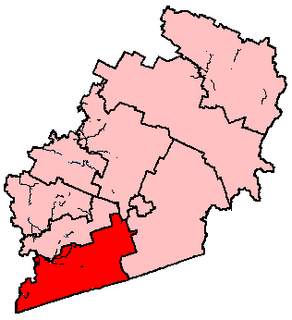
Brome—Missisquoi is a federal electoral district in Quebec, Canada, that has been represented in the House of Commons of Canada since 1925. The original electoral district of Missiquoi existed from 1867 to 1925.
Missisquoi was a federal electoral district in Quebec, Canada, that was represented in the House of Commons of Canada from 1867 to 1925.
Saint-Jean is a federal electoral district in Quebec, Canada, that has been represented in the House of Commons of Canada since 1968.
St. Johns—Iberville was a federal electoral district in Quebec, Canada, that was represented in the House of Commons of Canada from 1896 to 1935.
Cowansville is a town in south-central Quebec, Canada, located on Lac Davignon 20 kilometres (12 mi) north of the U.S. border. It is the seat of Brome-Missisquoi, a regional county municipality. The population as of the Canada 2011 Census was 12,489.
Farnham is a city in Brome-Missisquoi Regional County Municipality in the Montérégie region of Quebec, Canada. The population as of the Canada 2011 Census was 8,330, making it the second most populated community in the RCM.
Route 202 is an east/west 140-kilometre highway in the Monteregie region of the province of Quebec, Canada. Its western terminus is at the junction of Route 132 in Sainte-Barbe and its eastern terminus is in southern Cowansville at the junctions of Route 104 and Route 139. The highway runs a few kilometres north of the United States-Canada border for most of its length.
The Diocese of Montreal is a diocese of the Ecclesiastical Province of Canada of the Anglican Church of Canada, in turn a province of the Anglican Communion. The diocese comprises the 21,400 square kilometres (8,300 sq mi) encompassing the City and Island of Montreal, the Laurentians, the South Shore opposite Montreal, and part of the Eastern Townships. The See city is Montreal, and the cathedral is Christ Church. The diocese maintains approximately 9,000 on its parish rolls in about seventy parishes.
Brome-Missisquoi is a provincial electoral district in the Montérégie region of Quebec, Canada that elects members to the National Assembly of Quebec. It includes the municipalities of Bromont, Cowansville, Frelighsburg, Sutton, Saint-Armand and Farnham.
William Warren Lynch was a Canadian lawyer, politician, and judge in the province of Quebec.
Dunham is a city in the Canadian province of Quebec, located in Brome-Missisquoi Regional County Municipality. The population as of the Canada 2011 Census was 3,471.
Stanbridge East is a municipality in the Canadian province of Quebec, located within the Brome-Missisquoi Regional County Municipality. The population as of the Canada 2011 Census was 873.
Pike River is a tributary of lake Champlain, flowing successively in:
Tétrault or Tetrault may refer to:
The Rivière aux Brochets Nord is a tributary of the Pike River. This watercourse crosses the territory of the municipalities of Dunham and Stanbridge East in the Brome-Missisquoi Regional County Municipality, in the administrative region of Montérégie, in the province of Quebec, in Canada.
The Rivière du Sud-Ouest is a tributary of the Yamaska River. It flows in the administrative region of Montérégie, on the South Shore of the St. Lawrence River, in Quebec, Canada. Its course towards the northeast crosses the municipalities of:
The Écossais River is a tributary of the Yamaska River. It flows in the administrative region of Montérégie, on the South Shore of the Saint Lawrence River, in Quebec, Canada. Its course towards the north-east successively crosses the municipalities of:
This page is based on this Wikipedia article Text is available under the CC BY-SA 4.0 license; additional terms may apply. Images, videos and audio are available under their respective licenses.