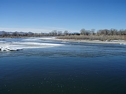
Three Forks is a city in Gallatin County, Montana, United States and is located within the watershed valley system of both the Missouri and Mississippi rivers drainage basins — and is historically considered the birthplace or start of the Missouri River. The population was 1,869 at the 2010 census. The city of Three Forks is named so because it lies geographically near the point, in nearby Missouri Headwaters State Park, where the Jefferson, Madison, and Gallatin Rivers converge to form the Missouri River — the longest single river in North America, as well as the major portion of the Missouri-Mississippi River System from the headwaters near Three Forks to its discharge into the Gulf of Mexico. Three Forks is part of the Bozeman, MT Micropolitan Statistical Area of approximately 100,000 people and located thirty miles west of Bozeman.

The source, or headwaters, of a river or stream is the farthest place in that river or stream from its estuary or confluence with another river, as measured along the course of the river.

The Bitterroot Range is a mountain range and a subrange of the Rocky Mountains that runs along the border of Montana and Idaho in the northwestern United States. The range spans an area of 24,223 square miles (62,740 km2) and is named after the bitterroot, a small pink flower that is the state flower of Montana.
The Jefferson River is a tributary of the Missouri River, approximately 83 miles (134 km) long, in the U.S. state of Montana. The Jefferson River and the Madison River form the official beginning of the Missouri at Missouri Headwaters State Park near Three Forks. It is joined 0.6 miles (1.0 km) downstream (northeast) by the Gallatin.

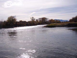
The Beaverhead River is an approximately 69-mile-long (111 km) tributary of the Jefferson River in southwest Montana. It drains an area of roughly 4,778 square miles (12,370 km2). The river's original headwaters, formed by the confluence of the Red Rock River and Horse Prairie Creek, are now flooded under Clark Canyon Reservoir, which also floods the first 6 miles (9.7 km) of the river. The Beaverhead then flows through a broad valley northward to join the Big Hole River and form the Jefferson River. With the Red Rock River included in its length, the river stretches another 70 miles (110 km), for a total length of 139 miles (224 km), one of the more significant drainages of south-western Montana.

The Madison River is a headwater tributary of the Missouri River, approximately 183 miles (295 km) long, in Wyoming and Montana. Its confluence with the Jefferson and Gallatin rivers near Three Forks, Montana forms the Missouri River.

The Gallatin River is a tributary of the Missouri River, approximately 120 mi, in the U.S. states of Wyoming and Montana. It is one of three rivers, along with the Jefferson and Madison, that converge near Three Forks, Montana, to form the Missouri.

Mount Jefferson is a mountain located on the Continental Divide between Fremont County of northeastern Idaho and Beaverhead County of southwestern Montana. Mount Jefferson is the highest point of the Centennial Mountains, whose crest runs along the Continental Divide and can be climbed using a class 2 route (scramble) from the access road to neighboring Sawtell Peak.
This is the timeline of the Lewis and Clark Expedition through the American West (1803–1806).

Lemhi Pass is a high mountain pass in the Beaverhead Mountains, part of the Bitterroot Range in the Rocky Mountains and within Salmon-Challis National Forest. The pass lies on the Montana-Idaho border on the continental divide, at an elevation of 7,373 feet (2,247 m) above sea level. It is accessed via Lemhi Pass Road in Montana, and the Lewis and Clark Highway in Idaho, both dirt roads. Warm Springs Road, which roughly follows the divide in Montana, passes just west of the pass's high point.

The Lewis and Clark National Historic Trail is a route across the United States commemorating the Lewis and Clark Expedition of 1804 to 1806. It is part of the National Trails System of the United States. It extends for some 3,700 miles (6,000 km) from Wood River, Illinois, to the mouth of the Columbia River in Oregon.
The Beaverhead–Deerlodge National Forest is the largest of the National Forests in Montana, United States. Covering 3.36 million acres (13,600 km2), the forest is broken into nine separate sections and stretches across eight counties in the southwestern area of the state. President Theodore Roosevelt named the two forests in 1908 and they were merged in 1996. Forest headquarters are located in Dillon, Montana. In Roosevelt's original legislation, the Deerlodge National Forest was called the Big Hole Forest Reserve. He created this reserve because the Anaconda Copper Mining Company, based in Butte, Montana, had begun to clearcut the upper Big Hole River watershed. The subsequent erosion, exacerbated by smoke pollution from the Anaconda smelter, was devastating the region. Ranchers and conservationists alike complained to Roosevelt, who made several trips to the area. (Munday 2001)

Beaverhead Rock, also known as Point of Rocks, is a rock formation overlooking the Beaverhead River in Montana protected as Beaverhead Rock State Park. It is located on Montana State Highway 41, twelve miles (19 km) south of Twin Bridges, Madison County. It was added to the National Register of Historic Places in 1970. The site may be viewed and photographed from a distance, but is not directly accessible.

Brower's Spring is a spring in the Centennial Mountains of Montana that was marked by a surveyor in 1888 as the ultimate headwaters of the Missouri River and thus the fourth longest river in the world, the 3,902-mile (6,280 km)-long Mississippi-Missouri River.

Jacob Vandenberg Brower (1844–1905) was a prolific writer of the Upper Midwest region of the United States who championed the location and protection of the utmost headwaters of the Mississippi and Missouri rivers.

The Madison Range is a mountain range located in the Rocky Mountains of Montana and Idaho in the United States. The range was named in honor of future President of the United States, then U.S. Secretary of State James Madison by Meriwether Lewis as the Lewis and Clark Expedition travelled through Montana in 1805. The range extends 80 miles (130 km) from West Yellowstone, Montana to Bozeman, Montana and is flanked by the Madison River on the west and the Gallatin River to the east. The highest point in the range is Hilgard Peak at 11,316 ft (3,449 m), a remote peak that wasn't climbed until 1948.

Yorks Islands, also known as "Yorks 8 Islands" or "York's Islands" or simply "York Island(s)" are a group of several islands in the flood plain of the Missouri River, in Broadwater County, Montana, about 4 miles south (up-river) from Townsend, Montana, along U.S. Highway 287. The islands were named by the Lewis and Clark Expedition (1803–1806) for Clark's slave York, when the expedition passed this way in 1805 on their historic journey of exploration to the Pacific Ocean. The islands may be accessed from U.S.287, as a Montana Fishing Access site.
Lewis and Clark Pass, el. 6,424 feet (1,958 m) is a mountain pass on the continental divide in Montana. It lies at the head of the drainages of the west flowing Blackfoot River and the east flowing Dearborn River. The pass is in the Helena National Forest in Lewis and Clark County. The Continental Divide Trail traverses north and south through the pass. At the time of the Lewis and Clark Expedition the pass was a much-used pathway where the native people living in what today is Montana crossed over the continental divide. The pass was crossed by Meriwether Lewis on July 7, 1806, on the return leg of the Lewis and Clark Expedition with a party of nine men and his dog Seaman. The pass was named for the expedition's two leaders–Lewis and William Clark. Lewis and Clark Pass is the only roadless pass on the entire Lewis and Clark National Historic Trail. It has gone from being one of the most used continental divide passes prior to the pioneer era to one of the least visited passes today. It can be accessed by a 1.5-mile (2.4 km) trail. Visitors will encounter the pass much as Lewis did in 1806. The furrows left by the countless dog and horse travois that crossed the pass are still visible and this is one of the places along the expedition's route that visitors may still encounter a grizzly bear. On a clear day, like Meriwether Lewis in 1806 one can see Square Butte in Cascade County, Montana, 40 miles (64 km) to the northeast.

Tower Rock State Park is a state park near the community of Cascade in the U.S. state of Montana in the United States. The centerpiece of the park is Tower Rock, a 424-foot (129 m)-high rock formation which marks the entrance to the Missouri River Canyon in the Adel Mountains Volcanic Field. It was well known to Native Americans, and considered a sacred place by the Piegan Blackfeet. Tower Rock received its current name when Meriwether Lewis of the Lewis and Clark Expedition visited the site in 1805. Railroad and highway development in the late 1800s and 1900s skirted Tower Rock, but the landform itself remained pristine. The 87.2 acres (0.353 km2) encompassing Tower Rock was added to the National Register of Historic Places on March 18, 2002. The 140-acre (0.57 km2) Tower Rock State Park was created around the National Historic Site in 2004.