Mittlerer Sonnblick

Last updated
Mittlerer Sonnblick

Grosser und Mittlerer Sonnblick.JPG

Großer Sonnblick (centre) and Mittlerer Sonnblick (right)
Highest point
Elevation 3,000  m (AA) (9,800 ft)
Prominence 100 m
Isolation 0.660 km
Listing easternmost 3,000er of the Alps
Coordinates 47°03′09″N13°25′51″E / 47.0525°N 13.43083°E / 47.0525; 13.43083 Coordinates: 47°03′09″N13°25′51″E / 47.0525°N 13.43083°E / 47.0525; 13.43083
Geography
Austria relief location map.jpg
Red triangle with thick white border.svg
Mittlerer Sonnblick
Parent range Ankogel Group, High Tauern

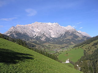
The Mittlerer Sonnblick is a 3,000 metre high [1] sub-peak of the Großer Sonnblick (3,030 m) to which it is linked by a knife-edge ridge. It is a border peak between the two Austrian federal states of Carinthia and Salzburg. It lies within the Ankogel Group of mountains, a sub-group of the High Tauern.

Metres above the Adriatic elevation measure

Metres above the Adriatic is the vertical datum used in Austria, in the former Yugoslavian states of Slovenia, Croatia, Bosnia-Hercegovina, Serbia, Montenegro, North Macedonia, Kosovo, as well as in Albania to measure elevation, referring to the average water level of the Adriatic Sea at the Sartorio mole in the Port of Trieste.

Großer Sonnblick mountain

The Großer Sonnblick or Malteiner Sonnblick, a mountain with a height of 3,030 m (AA), is a peak in the Ankogel Group of the Hohe Tauern range in Austria. It is the easternmost peak of the Alps with a prominence over 100 metres that exceeds a height of 3,000 metres (9,800 ft).

Austria Federal republic in Central Europe

Austria, officially the Republic of Austria, is a country in Central Europe comprising 9 federated states. Its capital, largest city and one of nine states is Vienna. Austria has an area of 83,879 km2 (32,386 sq mi), a population of nearly 9 million people and a nominal GDP of $477 billion. It is bordered by the Czech Republic and Germany to the north, Hungary and Slovakia to the east, Slovenia and Italy to the south, and Switzerland and Liechtenstein to the west. The terrain is highly mountainous, lying within the Alps; only 32% of the country is below 500 m (1,640 ft), and its highest point is 3,798 m (12,461 ft). The majority of the population speaks local Bavarian dialects as their native language, and German in its standard form is the country's official language. Other regional languages are Hungarian, Burgenland Croatian, and Slovene.

The mountain has a prominence of 100 metres and an isolation of 660 metres. [2]

The peak has achieved certain renown, no doubt because it is the easternmost three-thousander in the Alps. It is certainly not wrong to say that the Großer Sonnblick is the easternmost mountain in the Alps that exceeds the 3,000-metre mark, but it is not the easternmost point in the Alps that reaches that height.

Three-thousanders are mountains with a height of between 3,000 metres (9,800 ft), but less than 4,000 metres (13,000 ft) above sea level. Similar terms are commonly used for mountains of other height brackets e. g. four-thousanders or eight-thousanders. In Britain, the term may refer to mountains above 3,000 feet (910 m).

Alps Major mountain range system in Central Europe

The Alps are the highest and most extensive mountain range system that lies entirely in Europe, separating Southern from Central and Western Europe and stretching approximately 1,200 kilometres (750 mi) across eight Alpine countries : France, Switzerland, Italy, Monaco, Liechtenstein, Austria, Germany, and Slovenia. The mountains were formed over tens of millions of years as the African and Eurasian tectonic plates collided. Extreme shortening caused by the event resulted in marine sedimentary rocks rising by thrusting and folding into high mountain peaks such as Mont Blanc and the Matterhorn. Mont Blanc spans the French–Italian border, and at 4,810 m (15,781 ft) is the highest mountain in the Alps. The Alpine region area contains about a hundred peaks higher than 4,000 metres (13,000 ft).

Related Research Articles

High Tauern A mountain range of the eastern Alps

The High Tauern are a mountain range on the main chain of the Central Eastern Alps, comprising the highest peaks east of the Brenner Pass. The crest forms the southern border of the Austrian states of Salzburg, Carinthia and East Tyrol, with a small part in the southwest belongs to the Italian province of South Tyrol. The range includes Austria's highest mountain, the Grossglockner at 3,798 metres (12,461 ft) above the Adriatic.

Uri Alps mountain range

The Uri Alps are a mountain range in Central Switzerland and part of the Western Alps. They extend into the cantons of Obwalden, Valais, Bern, Uri and Nidwalden and are bordered by the Bernese Alps and the Emmental Alps to the west, the Schwyzer Alps to the north, the Lepontine Alps to the south and the Glarus Alps to the east (Reuss).

Allgäu Alps mountain range in the Northern Limestone Alps

The Allgäu Alps are a mountain range in the Northern Limestone Alps, located in Bavaria in Germany and Tyrol and Vorarlberg in Austria. The range lies directly east of Lake Constance.

Berchtesgaden Alps mountain range of the Northern Limestone Alps

The Berchtesgaden Alps are a mountain range of the Northern Limestone Alps, named after the market town of Berchtesgaden located in the centre. The central part belongs to the Berchtesgadener Land district of southeastern Bavaria, Germany, while the adjacent area in the north, east and south is part of the Austrian state of Salzburg.

Hochwanner mountain

At 2,744 metres (9,003 ft), the Hochwanner is the second highest mountain in Germany after the Zugspitze. In addition the Hochwanner is the highest peak on the main ridge of the Wetterstein (Wettersteinhauptkamm) running from Gatterl to the Upper Wettersteinspitze above Mittenwald in an east-west direction. From the Hochwanner massif there is an all-round view of the Rein valley (Reintal), the Leutasch valley in Austria, the Gais valley, the Zugspitze, the Mieming Chain, the Jubiläumsgrat, the Karwendel mountains and far into the central Alps.

Alpine Club classification of the Eastern Alps mountain range

The Alpine Club classification of the Eastern Alps is a common division of the Eastern Alps into 75 mountain ranges, based on the Moriggl Classification (ME) first published in 1924 by the German and Austrian Alpine Club. The present-day division established for the German-speaking world was compiled by the German, Austrian and South Tyrol Alpine Clubs and published in 1984 and is also used for the basic numbering of Alpine Club maps for mountaineering.

Mangfall Mountains mountain range

The Mangfall Mountains, or sometimes Mangfall Alps, are the easternmost part of the Bavarian Prealps that, in turn, belong to the Northern Limestone Alps. The name comes from the river Mangfall, whose tributaries, the Rottach, Weißach, Schlierach and Leitzach, drain large parts of the area and form an important drinking water reservoir for the city of Munich.

Granatspitze Group mountain range of the Austrian Alps

The Granatspitze Group, sometimes also the Granatspitz Group, is a sub-group of the Central Alps within the Eastern Alps. Together with the Ankogel Group, the Goldberg Group, the Glockner Group, the Schober Group, the Kreuzeck Group, the Venediger Group, the Villgraten Mountains and the Rieserferner Group, the Granatspitze Group forms the main range known as the High Tauern. The Granatspitze Group is located in Austria in the federal states of Salzburg and Tyrol. Its highest summit is the Großer Muntanitz, 3,232 m (AA)

Steinernes Meer mountain range

The Steinernes Meer is a high karst plateau in the Northern Limestone Alps. As one of the nine sub-ranges of the Berchtesgaden Alps the Steinernes Meer belongs partly to Bavaria and partly to Salzburg.

Hinterer Bratschenkopf mountain

The Hinterer Bratschenkopf is a mountain in the Glockner Group on the Fusch-Kaprun ridge in the High Tauern, a high mountain range in the Austrian Central Alps. According to the listed sources it is 3,412 metres high, but the Austrian Federal Office for Metrology and Survey gives its height as 3,413 metres. The mountain lies in the Austrian state of Salzburg. It appears from the north, east and south as a gently curved firn summit, but from the west it has a mighty, 1,400-metre-high (4,600 ft) and 40 to 60° rock face. A steep, 500-metre-long (1,600 ft) knife-edge ridge bears away from the mountaintop to the north. Due to its close proximity to the Heinrich Schwaiger Haus, the summit is a popular viewing point. The peak was first climbed on 18 September 1869 by the Munich Alpinist, Karl Hofmann, the Prague businessman, Johann Stüdl, and mountain guides Thomas Groder and Josef Schnell from Kals am Großglockner.

Two-thousander

Two-thousanders are mountains that have a height of at least 2,000 metres above sea level, but less than 3,000 metres. The term is used in Alpine circles, especially in Europe.

Ankogel Group mountain range

The Ankogel Group is a sub-group of the Central Eastern Alps. Together with the Goldberg Group, the Glockner Group, the Schober Group, the Kreuzeck Group, the Granatspitze Group, the Venediger Group, the Villgraten Mountains and the Rieserferner Group it forms the mountain range of the Hohe Tauern.

Goldberg Group mountain range

The Goldberg Group is a sub-group of the Hohe Tauern mountain range within the Central Eastern Alps. It is located in Austria, in the states of Salzburg and Carinthia. Its highest peak is the Hocharn, 3,254 m (AA). Other well known summits are the Hoher Sonnblick, with its observatory at 3,106 m above sea level (AA), and the Schareck at 3,123 m above sea level (AA)

Großer Hafner

Großer Hafner is a 3,076 m (10,092 ft) high partly-glaciated mountain of the Ankogel Group in the High Tauern range, located at the border between the Austrian states of Carinthia and Salzburg. It is the easternmost three-thousander peak of the range, and also in the entire Alps.

Hoher Sonnblick mountain

The Hoher Sonnblick is a glaciated mountain, 3,106 m (AA) high, on the main Alpine chain in the Goldberg Group on the border between the Austrian states of Carinthia and Salzburg. At its summit is the Sonnblick Observatory and the Alpine refuge hut of Zittelhaus.

Großer Geiger mountain

The Großer Geiger, formerly also called the Obersulzbacher Venediger and Heiliggeistkogel, is a mountain, 3,360 m (AA), in the Venediger Group in the main chain of the Central Tauern. This chain lies in the High Tauern, part of the Austrian Central Alps on the border between the Austrian states of Tyrol in the south and Salzburg in the north.

Seekopf is German for “lake head” or “lake peak” and may refer to the following mountains:

A number of mountains are called Sonnblick:

References

  1. Mittlerer Sonnblick 3000 m 9840 ft. at www.hikr.org. Accessed on 10 July 2011.
  2. Tour 567 - Großer Hafner, Großer Sonnblick, Mittlerer Sonnblick, Petereck at www.thehighrisepages.de. Accessed on 10 Jul 2011.