Tecoh Municipality is one of 106 municipalities in Yucatán State, Mexico., located 40 km south-east of Mérida, Yucatán. It has a municipal capital of the same name. As of 2003, the city Tecoh had a population of about 8,500 people. Most of the population is Maya. A number of buildings in the town were built atop older Pre-Columbian foundations. "Tecoh" means "Place of the Puma" in the Yucatec Maya language, which is still widely spoken here.
Municipalities are the second-level administrative divisions of Mexico, where the first-level administrative division is the state. As of the establishment of two new municipalities in Chiapas in September 2017, there are 2,448 municipalities in Mexico, not including the 16 delegaciones of Mexico City. The internal political organization and their responsibilities are outlined in the 115th article of the 1917 Constitution and detailed in the constitutions of the states to which they belong.

Tarandacuao is a Mexican city located in the lowlands of the state of Guanajuato. The municipality has an area of 117.39 square kilometres, and is bordered to the north and east by Jerécuaro, to the south by the state of Michoacán, and to the west by Acámbaro. The municipality had 11,583 inhabitants according to the 2005 census. Outlying communities found in Tarandacuao include La Purísima,San Juan De Dios, San José de Hidalgo, San Antonio, El Tocuz, San felipe and La Virgen.

Xichú is a Mexican city located in the Northeast region of the state of Guanajuato. The municipality is entirely within the Sierra Gorda range and has an area of 912.20 square kilometres. It is bordered to the north by the state of San Luis Potosí, to the east by Atarjea, to the south by the state of Querétaro and Santa Catarina and to the west by Victoria. The municipality had a population of 11,323 inhabitants according to the 2005 census.

San José Iturbide is a Mexican city located in the Northeast region of the state of Guanajuato, within the Sierra Gorda range. The municipality has an area of 534.11 square kilometres and is bordered to the north by San Luis de la Paz and Doctor Mora, to the east by Tierra Blanca, to the south by the state of Querétaro, and to the west by San Miguel de Allende. The municipality had a population of 54,661 inhabitants according to the 2005 census.
Comonfort is a Mexican city and municipality named after Mexican general and president Ignacio Comonfort located in the state of Guanajuato. The municipality has an area of 485.90 square kilometres and is bordered to the north and northeast by San Miguel de Allende, to the east by the state of Querétaro, to the south and southwest by Empalme Escobedo, Apaseo el Grande, Celaya and Santa Cruz de Juventino Rosas, respectively. The municipality had a population of 67,642 inhabitants according to the 2005 census.
Huanímaro is a Mexican city located in Southwest region of the state of Guanajuato. The municipality has an area of 130.57 square kilometres and is bordered to the north and west by Abasolo, to the south by the state of Michoacán, and to the east by Valle de Santiago. The municipality had a population of 19,693 inhabitants according to the 2005 census.
Cuerámaro is a Mexican city located in Southwest region of the state of Guanajuato. The municipality has an area of 254.85 square kilometres and is bordered to the north by Romita, to the east by Abasolo, to the south by Pénjamo, and to the west by Manuel Doblado. The municipality had a population of 25,610 inhabitants according to the 2005 census.

City Manuel Doblado is a Mexican municipality located in the State of Guanajuato, Mexico. Its municipal seat is the city of the same name. City Manuel Doblado has an area of 810.43 square kilometres and is bordered to the north by Romita, Purísima del Rincón and San Francisco del Rincón, to the southeast by Cuerámaro, to the south by Pénjamo, and to the west by the state of Jalisco. The municipality had a population of 38,309 inhabitants according to the 2005 census.

Peto Municipality is one of 106 municipalities in Yucatán State, Mexico. It has a municipal seat of the same name and is located in the centre-south portion of the Yucatán, 135 km to the south-east of state capital Mérida.

Mezquital is a city and seat of the Municipality of Mezquital in the state of Durango, north-western Mexico. It is situated in the northeast of the municipality, near the boundary with the Municipality of Suchil. As of 2010, the town had a population of 1,742.

Tekom Municipality is a municipality in the Mexican state of Yucatán. Tekom is also the name of the municipality's largest settlement and seat of the municipal government. In the XII national census conducted by INEGI in 2000, Tekom municipality recorded a population of 2,660 inhabitants. In the intermediate census count undertaken by INEGI in 2005, the total municipal population was recorded as 2,933 inhabitants, 2,413 of whom spoke one of the recognised indigenous languages of Mexico.
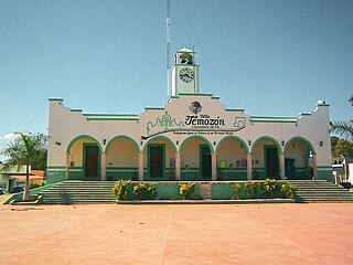
Temozón Municipality is one of the 106 subdivisions of the State of Yucatán in Mexico. Its municipal seat is located in the City of Temozón.

Tzucacab Municipality is one of the 106 subdivisions of the State of Yucatán in Mexico. Its municipal seat is located in the City of Tzucacab.

Puebla Municipality is a municipality in the State of Puebla in eastern Central Mexico. The municipality covers a total area of 534.32 square kilometres (206.30 sq mi). The City of Puebla is the municipal seat, as well as the capital of the state.
Tamazunchale is a town and municipality in the state of San Luis Potosí, central Mexico. In 2010 the area of the municipality was 354 square kilometres (137 sq mi) and the population was 96,820. The population of the town was 24,562.
The Guerrero Nahuatl language is a Nahuan language spoken by 150,000 people in Mexico.
The Cuicatecs are an indigenous people of Mexico. The Cuicatecs traditionally speak the Cuicatec language and are closely related to the Mixtecs.

Abalá Municipality is one of the 106 municipalities in the Mexican state of Yucatán containing (301.45 km2) of land and located roughly 50 km south of the city of Mérida.