Mondovi, Wisconsin

Last updated

Mondovi, Wisconsin
Mondovi, July 4, 2020.jpg
Fireworks seen from W. Hudson St. and S. Eau Claire St., July 4, 2020.
Buffalo County Wisconsin Incorporated and Unincorporated areas Mondovi Highlighted.svg
Location of Mondovi in Buffalo County, Wisconsin.
Coordinates: 44°34′8″N91°40′11″W / 44.56889°N 91.66972°W / 44.56889; -91.66972
Country Flag of the United States.svg  United States
State Flag of Wisconsin.svg  Wisconsin
County Buffalo
Area
[1]
  Total3.98 sq mi (10.31 km2)
  Land3.90 sq mi (10.09 km2)
  Water0.09 sq mi (0.22 km2)
Elevation
[2]
804 ft (245 m)
Population
 (2010) [3]
  Total2,777
  Estimate 
(2019) [4]
2,564
  Density658.11/sq mi (254.08/km2)
Time zone UTC-6 (Central (CST))
  Summer (DST) UTC-5 (CDT)
Area code(s) 715 & 534
FIPS code 55-53600 [5]
GNIS feature ID1569650 [2]
Website www.mondovi.com

Mondovi is a city along the Buffalo River in Buffalo County, Wisconsin, United States. The population was 2,777 at the 2010 census. The city is mostly surrounded by the Town of Mondovi, with a small portion surrounded by the Town of Naples.

Contents

History

A post office called Mondovi has been in operation since 1854. [6] Mondovi was laid out in 1855. [7] The city was named in commemoration of the Battle of Mondovì. [7]

Geography

Mondovi is located at 44°34′7″N91°40′10″W / 44.56861°N 91.66944°W / 44.56861; -91.66944 (44.568865, -91.669634). [8]

According to the United States Census Bureau, the city has a total area of 3.91 square miles (10.13 km2), of which, 3.82 square miles (9.89 km2) is land and 0.09 square miles (0.23 km2) is water. [9]

Climate

Climate data for Mondovi, Wisconsin, 1991–2020 normals, extremes 1908present
MonthJanFebMarAprMayJunJulAugSepOctNovDecYear
Record high °F (°C)56
(13)
64
(18)
84
(29)
92
(33)
108
(42)
102
(39)
110
(43)
104
(40)
101
(38)
96
(36)
79
(26)
65
(18)
110
(43)
Mean maximum °F (°C)45.6
(7.6)
50.0
(10.0)
65.7
(18.7)
80.6
(27.0)
87.9
(31.1)
91.8
(33.2)
93.1
(33.9)
91.6
(33.1)
87.1
(30.6)
80.6
(27.0)
64.1
(17.8)
49.2
(9.6)
94.7
(34.8)
Average high °F (°C)27.0
(−2.8)
32.4
(0.2)
45.4
(7.4)
60.4
(15.8)
72.5
(22.5)
81.0
(27.2)
84.9
(29.4)
82.4
(28.0)
74.7
(23.7)
61.2
(16.2)
44.7
(7.1)
31.7
(−0.2)
58.2
(14.5)
Daily mean °F (°C)17.1
(−8.3)
21.6
(−5.8)
34.0
(1.1)
47.3
(8.5)
59.3
(15.2)
68.7
(20.4)
72.5
(22.5)
70.2
(21.2)
62.4
(16.9)
49.5
(9.7)
35.3
(1.8)
22.9
(−5.1)
46.7
(8.2)
Average low °F (°C)7.2
(−13.8)
10.8
(−11.8)
22.6
(−5.2)
34.2
(1.2)
46.1
(7.8)
56.3
(13.5)
60.1
(15.6)
58.0
(14.4)
50.2
(10.1)
37.7
(3.2)
25.9
(−3.4)
14.2
(−9.9)
35.3
(1.8)
Mean minimum °F (°C)−21.0
(−29.4)
−14.9
(−26.1)
−3.6
(−19.8)
16.4
(−8.7)
28.2
(−2.1)
39.9
(4.4)
47.1
(8.4)
44.2
(6.8)
31.6
(−0.2)
20.1
(−6.6)
6.4
(−14.2)
−12.1
(−24.5)
−23.5
(−30.8)
Record low °F (°C)−45
(−43)
−43
(−42)
−34
(−37)
−5
(−21)
18
(−8)
29
(−2)
36
(2)
32
(0)
21
(−6)
8
(−13)
−13
(−25)
−38
(−39)
−45
(−43)
Average precipitation inches (mm)1.09
(28)
1.13
(29)
2.05
(52)
3.39
(86)
4.29
(109)
5.25
(133)
4.12
(105)
4.89
(124)
3.85
(98)
2.45
(62)
1.98
(50)
1.39
(35)
35.88
(911)
Average snowfall inches (cm)11.8
(30)
11.6
(29)
9.5
(24)
3.8
(9.7)
0.3
(0.76)
0.0
(0.0)
0.0
(0.0)
0.0
(0.0)
0.0
(0.0)
0.7
(1.8)
4.5
(11)
11.0
(28)
53.2
(134.26)
Average precipitation days (≥ 0.01 in)9.48.29.512.013.112.710.610.49.89.58.39.9123.4
Average snowy days (≥ 0.1 in)9.27.85.02.30.10.00.00.00.00.43.78.837.3
Source 1: NOAA [10]
Source 2: National Weather Service [11]

Demographics

Historical population
CensusPop.Note
1880 295
1890 50370.5%
1900 1,208140.2%
1910 1,3259.7%
1920 1,55417.3%
1930 1,6234.4%
1940 2,07728.0%
1950 2,28510.0%
1960 2,3201.5%
1970 2,3380.8%
1980 2,5458.9%
1990 2,491−2.1%
2000 2,6345.7%
2010 2,7775.4%
2019 (est.)2,564 [4] −7.7%
U.S. Decennial Census [12]

2010 census

As of the census [3] of 2010, there were 2,777 people, 1,194 households, and 722 families living in the city. The population density was 727.0 inhabitants per square mile (280.7/km2). There were 1,303 housing units at an average density of 341.1 per square mile (131.7/km2). The racial makeup of the city was 96.7% White, 0.6% African American, 0.6% Native American, 0.5% Asian, 0.2% from other races, and 1.4% from two or more races. Hispanic or Latino of any race were 1.4% of the population.

There were 1,194 households, of which 32.1% had children under the age of 18 living with them, 42.6% were married couples living together, 13.8% had a female householder with no husband present, 4.0% had a male householder with no wife present, and 39.5% were non-families. 33.7% of all households were made up of individuals, and 17.7% had someone living alone who was 65 years of age or older. The average household size was 2.26 and the average family size was 2.89.

The median age in the city was 39.9 years. 24.2% of residents were under the age of 18; 8.4% were between the ages of 18 and 24; 23.5% were from 25 to 44; 23.8% were from 45 to 64; and 20% were 65 years of age or older. The gender makeup of the city was 46.3% male and 53.7% female.

2000 census

As of the census [5] of 2000, there were 2,634 people, 1,122 households, and 657 families living in the city. The population density was 695.2 people per square mile (268.3/km2). There were 1,232 housing units at an average density of 325.2 per square mile (125.5/km2). The racial makeup of the city was 98.71% White, 0.19% Black or African American, 0.30% Native American, 0.27% Asian, and 0.53% from two or more races. 0.46% of the population were Hispanic or Latino of any race.

There were 1,122 households, out of which 27.0% had children under the age of 18 living with them, 45.5% were married couples living together, 9.5% had a female householder with no husband present, and 41.4% were non-families. 36.7% of all households were made up of individuals, and 21.5% had someone living alone who was 65 years of age or older. The average household size was 2.26 and the average family size was 2.96.

In the city, the population was spread out, with 23.5% under the age of 18, 8.0% from 18 to 24, 24.8% from 25 to 44, 20.2% from 45 to 64, and 23.4% who were 65 years of age or older. The median age was 40 years. For every 100 females, there were 85.5 males. For every 100 females age 18 and over, there were 80.5 males.

The median income for a household in the city was $31,000, and the median income for a family was $40,954. Males had a median income of $30,947 versus $21,434 for females. The per capita income for the city was $17,023. About 8.8% of families and 11.2% of the population were below the poverty line, including 14.4% of those under age 18 and 10.3% of those age 65 or over.

Government

Elected City Officials

Appointed City Officials

Police Department

The Mondovi Police Department is a full time department offering 24/7 police service to the City of Mondovi. The department consists of four full-time sworn officers, and four part-time sworn officers. The Mondovi Police Department has an officer dedicated as a working K9 handler. The officer works with K9 Buck, a pure bred German Shepherd, who is certified in narcotics detection and tracking. The department also owns an All Terrain Vehicle, which it uses to patrol the city parks and the Buffalo River State Trail, which enters the city from the east.

Fire department

The Mondovi Fire Department consists of 30 volunteers.

Public works

The Public Works Department consists of 6 full-time employees.

Emergency medical service

The Mondovi Ambulance Service is a private service that operates in the City of Mondovi and surrounding areas. The staff consists of a number of volunteers. Mondovi EMS has two fully equipped ambulances.

City Council meetings

  • City Council meetings held the 2nd and 4th Tuesdays of each month January through October.
  • Meetings are held on the 2nd Tuesday only in November and December.
  • All regularly scheduled City Council meetings begin at 5:30 p.m.
  • Meeting notices and agendas are posted at Mondovi City Hall, Mondovi Post Office, Mondovi Police Department, Mondovi Public Library, Mondovi Herald-News Offices and are published in the Mondovi Herald-News weekly publication the Thursday before the meeting when possible.
  • Any updates to posted agendas can be made until 1:00 p.m. the day before the meeting.  
  • The Finance Committee meets on the Monday before the 2nd Tuesday of the month at 5:30 p.m.

Education

School District of Mondovi

The School District of Mondovi includes three schools. The Elementary School includes children in pre-school through Grade 5, the Middle School encompasses students in Grades 6 to 8, and the High School includes students in Grades 9-12. During the 2013-2014 school year, total enrollment was 966. The student-to-teacher ratio in pre-kindergarten through Grade 3 is no more than 18:1; the ratio in all other grades is less than 25:1. There are 78 certified staff, 3 administrators, and 46 full- or part-time support staff members.

District facilities include a complex in the city of Mondovi and another building, Anthony School, located about eight miles north of Mondovi on Highway 37. Students in Five-Year-Old Kindergarten through Grade 12 attend the city school; students participating in the Early Childhood program or the Four-Year-Old Kindergarten program attend Anthony School. The city complex includes an outdoor swimming pool, a distance learning center, a fine arts performance area, weight room, three indoor athletic areas, and an outdoor physical education area which includes newly-renovated tennis courts and running track, a football field, baseball and softball fields, and additional practice fields. [13]

Parks and Trails

Buffalo River State Trail

The Buffalo River State Trail passes through Mondovi offering a safe and scenic place for snowmobiling, horseback riding, ATV riding, hiking and biking.  The 36.4 mile multi-use trail runs from Mondovi to Fairchild, Wisconsin and passes farms, woods, hills, marshland and the Buffalo River. Several other multi-purpose recreational trails are located near Mondovi including the Red Cedar State Trail, Chippewa River State Trail and Great River State Trail

Joseph Peterson Arboretum

Joseph Peterson Arboretum is a 10-acre natural area.  Nearby public park area includes two volleyball courts, playground equipment and a picnic shelter.

Other Facilities:

Mirror Lake Park

Mirror Lake Park has a scenic view of Mondovi's Mirror Lake, playground equipment, picnic areas, and shelters. A public boat landing is located at the park and an accessible fishing pier accommodates anglers and sightseers of all abilities.

Sharps Point Park

Sharps Point Park is the site of the Mondovi Veteran's Memorial and is located along the banks of Mirror Lake.

Tourist Park

Six campsites are available on a first-come, first-served basis. The campsites offer electrical hook-ups, water, and a sanitary dump that is available at the City's wastewater treatment plant on weekdays from 8am-3pm. Two shelters can be reserved for special events, one of which is a historic log cabin. Tourist Park also has a museum on site that is open to the public. [14]

Notable people

See also

Related Research Articles

<span class="mw-page-title-main">Buffalo County, Wisconsin</span> County in Wisconsin, United States

Buffalo County is a county located in the U.S. state of Wisconsin. As of the 2020 census, the population was 13,317. Its county seat is Alma. The county was created in 1853 and organized the following year.

<span class="mw-page-title-main">Nora Springs, Iowa</span> City in Iowa, United States

Nora Springs is a city that is partially in Cerro Gordo and Floyd counties in the U.S. state of Iowa, along the Shell Rock River. The population was 1,369 at the time of the 2020 census.

<span class="mw-page-title-main">West St. Paul, Minnesota</span> City in Minnesota, United States

West St. Paul is a city in Dakota County, Minnesota, United States. The population was 20,615 at the 2020 census. It is immediately south of Saint Paul and immediately west of South St. Paul.

<span class="mw-page-title-main">Greenfield, Minnesota</span> City in Minnesota, United States

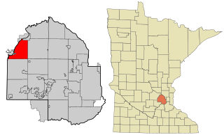
Greenfield is a city in northwestern Hennepin County, Minnesota. It has a population of 2,903 residents, according to the 2020 United States Census, and is located 26.5 miles northwest of Minneapolis. It is part of the Twin Cities Metropolitan Statistical Area.

<span class="mw-page-title-main">Buffalo, Missouri</span> City in Missouri, United States

Buffalo is a city in and the county seat of Dallas County, Missouri, United States. The population was 3,290 at the 2020 census.

<span class="mw-page-title-main">Crestwood, Missouri</span> City in the United States

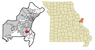
Crestwood is a city in south St. Louis County, Missouri, United States, part of the Metropolitan Statistical Area known as Greater St. Louis. The population was 11,912 at the 2010 census.

Buffalo is a town in Buffalo County in the U.S. state of Wisconsin. The population was 705 at the 2010 census. The unincorporated communities of Bluff Siding, East Winona, and Marshland are located in the town.

<span class="mw-page-title-main">Buffalo City, Wisconsin</span> City in Wisconsin, United States

Buffalo City is a city in Buffalo County in the U.S. state of Wisconsin. The population was 1,023 at the 2010 census.

<span class="mw-page-title-main">Naples, Wisconsin</span> Town in Wisconsin, United States

Naples is a town in Buffalo County in the U.S. state of Wisconsin. The population was 697 at the 2020 census.

<span class="mw-page-title-main">Mauston, Wisconsin</span> City in Wisconsin, United States

Mauston is a city in and the county seat of Juneau County, Wisconsin, United States. The population was 4,347 as of the 2020 census. It is approximately 70 miles northwest from the state capital, Madison.

<span class="mw-page-title-main">Galesville, Wisconsin</span> City in Wisconsin, United States

Galesville is a city in Trempealeau County, Wisconsin, United States. The population was 1,662 at the 2020 census. A dam on Beaver Creek is located at Galesville, forming Lake Marinuka north of the city. The mayor is Vince Howe.

<span class="mw-page-title-main">Strum, Wisconsin</span> Village in Wisconsin, United States

Strum is a village in Trempealeau County, Wisconsin, along the Buffalo River. The population was 1,114 at the 2010 census.

<span class="mw-page-title-main">Sussex, Wisconsin</span> Village in Wisconsin, United States

Sussex is a village in Waukesha County, Wisconsin, United States, about 19 miles (31 km) northwest of Milwaukee and 9 miles (14 km) north of Waukesha. The village is 7.24 square miles (19 km2) at an elevation of 930 feet. The population was 11,487 at the 2020 census. It is part of the Milwaukee metropolitan area.

Mondovi is a town in Buffalo County in the U.S. state of Wisconsin. The population was 469 at the 2010 census. The city of Mondovi is located mostly within the town.

<span class="mw-page-title-main">Hustisford, Wisconsin</span> Village in Wisconsin, United States

Hustisford is a village in Dodge County, Wisconsin, United States. The population was 1,101 at the 2020 census. The village is located within the town of Hustisford.

<span class="mw-page-title-main">Montello, Wisconsin</span> City in Wisconsin, United States

Montello is a city in and the county seat of Marquette County, Wisconsin, United States. The population was 1,495 at the 2010 census. The Fox River flows through the city. Montello is home to the largest tree in Wisconsin. A notable attraction in the city is the former granite quarry, which has been transformed into a park with several waterfalls.

<span class="mw-page-title-main">Tomah, Wisconsin</span> City in Wisconsin, United States

Tomah is a city in Monroe County, Wisconsin, United States. The population was 9,570 as of the 2020 census. The city is surrounded by the Town of Tomah and the Town of La Grange.

<span class="mw-page-title-main">Reedsburg, Wisconsin</span> City in Sauk County, Wisconsin, United States

Reedsburg is a city in Sauk County, Wisconsin, United States. Located along the Baraboo River, it was founded in 1868, and was named for early settler David C. Reed. The city is surrounded by the Town of Reedsburg. It is part of the Baraboo Micropolitan Statistical Area.

<span class="mw-page-title-main">Sheboygan Falls, Wisconsin</span> Place in United States, Town of Rochester

Sheboygan Falls is a city in Sheboygan County, Wisconsin, United States. Its population was 8,210 at the 2020 census. The city's downtown is listed on the National Register of Historic Places and is the first Main Street Community in Wisconsin. The city is part of the Sheboygan, Wisconsin Metropolitan Statistical Area.

<span class="mw-page-title-main">Medford, Wisconsin</span> City in Wisconsin, United States

Medford is a city in Taylor County, in north-central Wisconsin, United States. The population was 4,349 at the 2020 census. The city is located mostly within the boundaries of the Town of Medford. It is the county seat of Taylor County.

References

  1. "2019 U.S. Gazetteer Files". United States Census Bureau. Retrieved August 7, 2020.
  2. 1 2 "US Board on Geographic Names". United States Geological Survey. October 25, 2007. Retrieved January 31, 2008.
  3. 1 2 "U.S. Census website". United States Census Bureau . Retrieved November 18, 2012.
  4. 1 2 "Population and Housing Unit Estimates". United States Census Bureau. May 24, 2020. Retrieved May 27, 2020.
  5. 1 2 "U.S. Census website". United States Census Bureau . Retrieved January 31, 2008.
  6. "Buffalo County". Jim Forte Postal History. Retrieved April 4, 2015.
  7. 1 2 Chicago and North Western Railway Company (1908). A History of the Origin of the Place Names Connected with the Chicago & North Western and Chicago, St. Paul, Minneapolis & Omaha Railways. p. 184.
  8. "US Gazetteer files: 2010, 2000, and 1990". United States Census Bureau. February 12, 2011. Retrieved April 23, 2011.
  9. "US Gazetteer files 2010". United States Census Bureau. Archived from the original on January 25, 2012. Retrieved November 18, 2012.
  10. "U.S. Climate Normals Quick Access – Station: Mondovi, WI". National Oceanic and Atmospheric Administration. Retrieved March 5, 2023.
  11. "NOAA Online Weather Data – NWS La Crosse". National Weather Service. Retrieved March 5, 2023.
  12. "Census of Population and Housing". Census.gov. Retrieved June 4, 2015.
  13. "School District of Mondovi". www.mondovi.k12.wi.us. Retrieved July 23, 2020.
  14. "Trails / Parks". www.mondovi.com. Retrieved July 23, 2020.
  15. Mulligan, William H. Jr.; Cooke, Chauncey Herbert (2007). A Badger Boy in Blue: The Civil War Letters of Chauncey H. Cooke. Detroit, Michigan: Wayne State University Press. p. 1. ISBN   978-0-8143-3343-3 . Retrieved March 29, 2016.