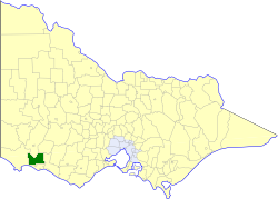
The Shire of Moyne is a local government area in the Barwon South West region of Victoria, Australia, located in the south-western part of the state. It covers an area of 5,478 square kilometres (2,115 sq mi) and at the 2016 Census had a population of approximately 16,500. It includes the towns of Port Fairy, Koroit, Mortlake, Macarthur, Peterborough, Caramut, Ellerslie, Framlingham, Garvoc, Hawkesdale, Kirkstall, Panmure, Mailors Flat, Purnim, Wangoom and Woolsthorpe. It also entirely surrounds the City of Warrnambool, a separate local government area. It was formed in 1994 from the amalgamation of the Shire of Belfast, Shire of Minhamite, Borough of Port Fairy, and parts of the Shire of Mortlake, Shire of Warrnambool, Shire of Dundas, Shire of Mount Rouse and Shire of Hampden.

Terang is a town in the Western District of Victoria, Australia. The town is in the Shire of Corangamite and on the Princes Highway 212 kilometres (132 mi) south west of the state's capital, Melbourne. At the 2006 census, Terang had a population of 1,824. At the 2001 census, Terang had a population of 1,859. The population of Terang has since risen according to the 2011 Census; the population is now 2,348, of which 1,155 are male and 1,193 are female, with the median age being 44.

Mortlake railway station is in the London Borough of Richmond upon Thames, in south London, and is in Travelcard Zone 3. It is 8 miles 21 chains (13.3 km) down the line from London Waterloo.

The electoral district of Polwarth is an electoral district of the Victorian Legislative Assembly. It is located in south-west rural Victoria, west of Geelong, and covers the Colac and Corangamite local government areas (LGA), parts of the Moyne, Golden Plains and Surf Coast LGAs, and slivers of the Ararat and Greater Geelong LGAs, running along the Great Ocean Road taking in Anglesea, Cape Otway, Peterborough, Aireys Inlet, Lorne, Wye River, Apollo Bay and Port Campbell, covering the inland towns of Winchelsea, Colac, Camperdown and Terang along the Princes Highway, and Inverleigh, Cressy, Lismore and Mortlake on the Hamilton Highway, and finally, includes the Otway Ranges and Lake Corangamite.

The Hopkins Highway in south-western Victoria, Australia is a short highway serving to link the Hamilton Highway at Mortlake with the Princes Highway at the port city of Warrnambool.

The Shire of Belfast was a local government area about 290 kilometres (180 mi) west-southwest of Melbourne, the state capital of Victoria, Australia. The shire covered an area of 5,190 square kilometres (2,003.9 sq mi), and existed from 1853 until 1994.

The Shire of Hampden was a local government area about 200 kilometres (124 mi) west-southwest of Melbourne, the state capital of Victoria, Australia. The shire covered an area of 2,620.91 square kilometres (1,011.9 sq mi), and existed from 1857 until 1994.
The Shire of Minhamite was a local government area located about 270 kilometres (168 mi) west of Melbourne, the state capital of Victoria, Australia. The shire covered an area of 1,365.62 square kilometres (527.3 sq mi), and existed from 1871 until 1994.

The Shire of Mortlake was a local government area about 220 kilometres (137 mi) west of Melbourne, the state capital of Victoria, Australia. The shire covered an area of 2,137 square kilometres (825.1 sq mi), and existed from 1860 until 1994.

The Shire of Warrnambool was a local government area located about 260 kilometres (162 mi) west-southwest of Melbourne, the state capital of Victoria, Australia. The shire covered an area of 1,605 square kilometres (619.7 sq mi), and existed from 1854 until 1994.

The Borough of Port Fairy was a local government area about 290 kilometres (180 mi) west-southwest of Melbourne, the state capital of Victoria, Australia. The borough covered an area of 22.72 square kilometres (8.8 sq mi), and existed from 1856 until 1994. Its area was surrounded by the Shire of Belfast and the Southern Ocean.
Woorndoo is a town in the Western District of Victoria, Australia. The town is in the Shire of Moyne local government area, 259 kilometres (161 mi) west of the state capital, Melbourne. At the 2016 census, Woorndoo and the surrounding area had a population of 169. The population of the town proper is around 50.
Luke Rounds is a former professional Australian rules footballer, who played for the Collingwood Football Club in the Australian Football League (AFL).
Hexham is a township in Victoria, Australia.
The Mortlake line is a closed railway line in the west of Victoria, Australia. Branching off the main Port Fairy railway at Terang, it ran north to Mortlake.

Dundas was an electoral district of the Legislative Assembly in the Australian state of Victoria from 1856 to 1976. It covered a region of western Victoria and consisted of the counties of Dundas and Follett.

The Mortlake Dispatchis a newspaper published in Mortlake, Victoria, Australia.