Mount Aka (Yatsugatake)

Last updated
Mount Aka
赤岳

Mt.Akadake from Mt.Yokodake 08.jpg

Mount Aka
Highest point
Elevation 2,899 m (9,511 ft) [1]
Prominence 1,916 m (6,286 ft) [1]
Listing List of mountains and hills of Japan by height
Ultra
Coordinates 35°58′14″N138°22′12″E / 35.97056°N 138.37000°E / 35.97056; 138.37000 Coordinates: 35°58′14″N138°22′12″E / 35.97056°N 138.37000°E / 35.97056; 138.37000 [1]
Naming
TranslationRed Mountain(Japanese)
Pronunciation Japanese:  [akadake]
Geography
Japan natural location map with side map of the Ryukyu Islands.jpg
Red triangle with thick white border.svg
Mount Aka
Japan
Location On the border of Chino, Hara of Nagano, and Hokuto of Yamanashi in Japan
Parent range Southern Yatsugatake Volcanic Group
Geology
Mountain type Stratovolcano
Volcanic arc/belt Northeastern Japan Arc

Mount Aka(赤岳,Aka-dake) is a 2,899m mountain on the border of Chino, Hara of Nagano, and Hokuto of Yamanashi in Japan. This mountain is the tallest mountain of Yatsugatake Mountains.

Chino, Nagano City in Chūbu, Japan

Chino is a city located in Nagano Prefecture, Japan. As of 1 March 2019, the city had an estimated population of 55,673 in 23,236 households, and a population density of 210 persons per km². The total area of the city is 266.59 square kilometres (102.93 sq mi).

Hara, Nagano Village in Chūbu, Japan

Hara is a village located in Nagano Prefecture, Japan. As of 1 October 2016, the village had an estimated population of 7,506, and a population density of 174 persons per km². Its total area is 43.26 square kilometres (16.70 sq mi).

Nagano Prefecture Prefecture of Japan

Nagano Prefecture is a prefecture located in the Chūbu region of Japan. The capital is the city of Nagano.

Contents

Description

Mount Aka is a stratovolcano. This mountain is a center of the Yatsugatake-Chūshin Kōgen Quasi-National Park.

Stratovolcano Tall, conical volcano built up by many layers of hardened lava and other ejecta

A stratovolcano, also known as a composite volcano, is a conical volcano built up by many layers (strata) of hardened lava, tephra, pumice and ash. Unlike shield volcanoes, stratovolcanoes are characterized by a steep profile with a summit crater and periodic intervals of explosive eruptions and effusive eruptions, although some have collapsed summit craters called calderas. The lava flowing from stratovolcanoes typically cools and hardens before spreading far, due to high viscosity. The magma forming this lava is often felsic, having high-to-intermediate levels of silica, with lesser amounts of less-viscous mafic magma. Extensive felsic lava flows are uncommon, but have travelled as far as 15 km (9.3 mi).

Yatsugatake-Chūshin Kōgen Quasi-National Park

Yatsugatake-Chūshin Kōgen Quasi-National Park is a quasi-national park on Honshū in Japan. It is rated a protected landscape according to the IUCN. The park includes the Yatsugatake Mountains and the surrounding lava plateaus: Tateshina plateau, Kirigamine, and Utsukushigahara. It straddles the border between Nagano and Yamanashi prefectures. Mount Aka is the highest point in the park at 2,899 m. The volcanoes of the Yatsugatake mountains erupted from the middle of the Fossa Magna (ja) and spread skirts of lava south, east and west. Lake Matsubara, Shirakoma Pond, and Lake Shirakaba attract tourists to the region for boating, skating, and camping. Utsukushigahara is a lava plateau at the northern end of the park and offers views of the Northern Alps. The extensive lava plateau of Kirigahara is popular for hiking. There are also a number of onsens in addition to the hotsprings at Tateshina. The park was designated a quasi-national in 1964.

Climbing route

There are several routes to reach to the top of Mount Aka. The most popular route is from Minoto. It takes about four and half hours.

Access

Mount Asama mountain in Nagano Prefecture, Japan

Mount Asama is an active complex volcano in central Honshū, the main island of Japan. The volcano is the most active on Honshū. The Japan Meteorological Agency classifies Mount Asama as rank A. It stands 2,568 metres (8,425 ft) above sea level on the border of Gunma and Nagano prefectures. It is included in 100 Famous Japanese Mountains.

Mount Iō (Yatsugatake) mountain in Nagano Prefecture, Japan

Mount Iō is a mountain on the border of Chino and Minamimaki, Nagano Prefecture, Japan. This mountain is one of the major mountains of Yatsugatake Mountains. Mount Iō literally means, sulphur mountain.

Mount Yoko (Southern Yatsugatake) mountain in Yamanashi Prefecture, Japan

Mount Yoko is located in the Southern Yatsugatake Volcanic Group of the Yatsugatake Mountains, Honshū, Japan.

See also

Related Research Articles

Tōmi, Nagano City in Chūbu, Japan

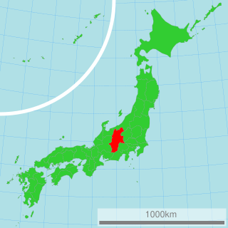
Tōmi is a city located in Nagano Prefecture, Japan. As of 1 April 2019, the city had an estimated population of 30,168 in 12068 households, and a population density of 270 persons per km². The total area of the city is 112.37 square kilometres (43.39 sq mi).

Mount Ishizuchi mountain in Ehime Prefecture, Japan

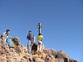
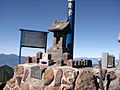
Mount Ishizuchi is a 1,982-metre-high (6,503 ft) mountain on the border of Saijō and Kumakōgen, in Ehime, Japan. This mountain is one of the 100 famous mountains in Japan. It is the highest mountain in Western Japan and the island of Shikoku.

Southern Yatsugatake Volcanic Group mountain range in Yamanashi Prefecture, Japan

Southern Yatsugatake Volcanic Group, also just Yatsugatake is a volcanic group of inactive volcanoes located on the border of Nagano Prefecture and Yamanashi Prefecture on Honshū in Japan.

Mount Tateshina mountain in Nagano Prefecture, Japan

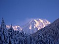
Mount Tateshina also Suwa Fuji is a complex volcano located on the border of the municipalities of Chino and Tateshina in Nagano Prefecture, Japan.

Sakuho, Nagano Town in Chūbu, Japan

Sakuho is a town located in Nagano Prefecture, Japan. As of 1 October 2016, the town had an estimated population of 11,091, and a population density of 58.9 persons per km². Its total area is 188.15 square kilometres (72.65 sq mi).

Kitayatsugatake Ropeway

The Kitayatsugatake Ropeway is the name of Japanese aerial lift line in Chino, Nagano, as well as its operator. The company also operates Pilatus Tateshina Snow Resort, a ski area served by the line. The company operates Tateshina Kōgen Art Museum at the submontane station as well. Opened in 1967, the line climbs Tateshina Highland (蓼科高原), transporting skiers and rime spectators in winter, hikers in other seasons. The observatory has a view of the Yatsugatake Mountains and Southern Alps.

Mount Kaikoma mountain in Yamanashi Prefecture, Japan

Mount Kaikoma is a mountain of the Akaishi Mountains, located on the border of Hokuto in Yamanashi Prefecture, and Ina in Nagano Prefecture, in the Chūbu region of Japan.

Mount Tengu mountain in Nagano Prefecture, Japan

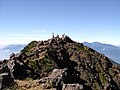
Mount Tengu is a 2,646m mountain on the border of Chino and Koumi of Nagano in Japan. This mountain is the highest mountains of Northern Yatsugatake Volcanic Group. Named for the mythical avian creatures of Japanese folklore, the Tengu.

Yatsugatake Mountains

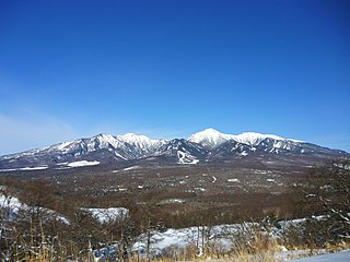
The Yatsugatake Mountains are a volcanic mountain range on the border between Nagano Prefecture and Yamanashi Prefecture on the island of Honshū in Japan.

Mount Nyū mountain in Nagano Prefecture, Japan

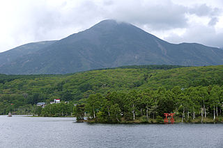
Mount Nyū is a stratovolcano of the Northern Yatsugatake Volcanic Group in Koumi, Nagano Prefecture, Japan. This mountain is part of the Yatsugatake-Chūshin Kōgen Quasi-National Park.

Northern Yatsugatake Volcanic Group mountain group in Yamanashi Prefecture, Japan

Northern Yatsugatake Volcanic Group is a volcanic group of stratovolcanoes and lava domes located in Nagano Prefecture on Honshū in Japan.

Mount Aka may refer to:

Mount Yoko also Mount Kita Yoko, is an active lava dome located in the Northern Yatsugatake Volcanic Group of the Yatsugatake Mountains, Honshū, Japan. Mount Yoko has shown the most recent activity and is now considered an active volcano. It last erupted about 800 years ago. The eruption consisted of ash with a lava flow of some 3 million cubic meters. The eruption was dated by corrected radiocarbon dating. The next previous eruption was in or after 400 BCE.

Mount Neishi mountain in Japan

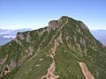
Mount Neishi is a 2,603m mountain on the border of Chino and Koumi of Nagano in Japan. This mountain belongs to Northern Yatsugatake Volcanic Group.

Mount Ōsasa mountain in Nagano Prefecture, Japan

Mount Ōsasa is a 1,807.3 m (5,929 ft) mountain of Chushin Highland, located in Nagawa, Nagano Prefecture, Japan. This mountain is a part of the Yatsugatake-Chūshin Kōgen Quasi-National Park.

Mount Denjō mountain in Nagano Prefecture, Japan

Mount Denjō is a 1,800 m (5,906 ft) mountain of Chushin Highland, located in Nagawa, Nagano. This mountain is a part of the Yatsugatake-Chūshin Kōgen Quasi-National Park.

Megami Lake is a lake located in Tateshina, Nagano Prefecture. An artificial lake constructed for agricultural purposes, it is also known as Akanuma Reservoir. A development to make it into a resort site is also underway. It is in Yatsugatake-Chūshin Kōgen Quasi-National Park.

References

  1. 1 2 3 "Japan Ultra-Prominences". Peaklist.org. Retrieved 2015-01-01.